Plenty of swell, cleanest in protected spots

South-east Queensland and Northern NSW Surf Forecast by Craig Brokensha (issued Wednesday 9th October)
Best Days: Thursday morning, Friday morning, Saturday morning south of Wooli-ish, Sunday protected spots, Monday morning, Tuesday morning
Recap
Poor quality and building N/NE windswell across SE Qld and NNSW yesterday, with a S'ly change coming late in the day, after dark on the Gold Coast. On the MNC there was a fun clean mix of swells on offer ahead of the change.
Today the swell has increased from the S'th across NNSW but with low quality, tiny and clean in protected spots across SE Qld.
This week and weekend (Oct 10 - 13)
These notes will be brief as Ben’s on annual leave.
The main point is there there's plenty of swell on the cards for the coming period across northern NSW (smaller SE Qld) and winds are looking generally favourable for protected spots.
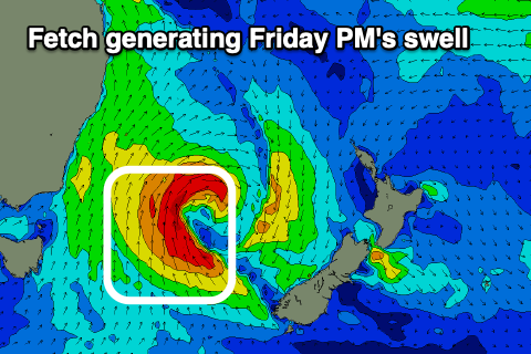 A deep Tasman Low is forming in the central Tasman Sea, with today's building S'ly swell generated by a broadening fetch of strong S'ly winds being projected up the southern NSW coast.
This swell should peak tomorrow morning coming in at 3-5ft across the Mid North Coast south swell magnets, possibly a touch smaller around Byron with the S/SW angle of the fetch and tiny on the Gold Coast with the odd set at south magnets. Localised SE windswell will be more dominant and to a weak 2ft.
Coming back to the deepening Tasman Low and this afternoon and evening we'll see gale-force S/SE winds generated around the core of the low.
A moderate sized mid-period S/SE is due off the gale-force fetch, arriving through Friday afternoon across northern NSW, and likely overnight in SE Qld.
Friday morning We'll fall between swells though short-range energy likely won't see sets dropping below 4ft across south swell magnets, with the new S/SE swell kicking to 4-5ft through the afternoon (visibly more lined up and powerful).
Conditions tomorrow will be cleanest across the MNC with a morning W/SW breeze, more SW-S/SW further north, shifting fresh S/SE-SE into the afternoon.
 Friday will play out similar but with less strength to the wind so conditions might be a little more lumpy/morning sick.
Moving into the weekend, and Friday's afternoon's swell will ease off into Saturday morning and a trough moving offshore will bring poor onshore E/NE tending E/SE winds across SE Qld and from Byron to about Wooli, with locations further south seeing a more variable W'ly winds ahead of sea breezes.
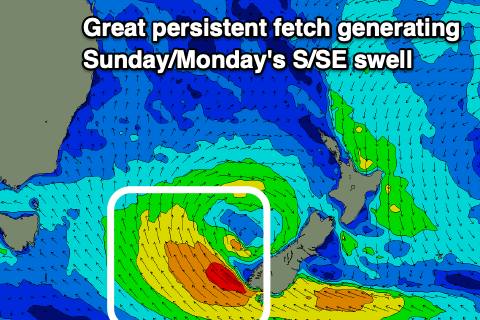
A good new S/SE swell should be seen into Sunday though, owing to the Tasman Low drifting slowly south-east tomorrow to a position just west of New Zealand's South Island.
A slight re-intensification of the low should result in a fetch of strong to gale-force SE winds being aimed towards the southern NSW coast from tomorrow afternoon through Friday before weakening Saturday morning.
The most size will be seen on the southern NSW coast, but we should see a moderate sized S/SE swell fill in Sunday across our regions, offering 4-5ft sets in northern NSW (odd 6ft'er across the MNC and swell magnets), coming in at 2-3ft across the Gold Coast.
Monday morning should see similar if not slightly smaller surf across all locations, easing through the day and down further Tuesday.
Winds on Sunday as the trough continues moving east look a little dicey and S/SE, much better Monday and W/SW tending E/SE through the day. NW tending strong NE winds will then favour south magnets on Tuesday as the swell eases.
Longer term there isn't too much on the cards at this stage, but more on this Friday.