Small surf to persist for some time; long term still looks promising

South-east Queensland and Northern NSW Surf Forecast by Ben Matson (issued Wednesday 13th March)
Best Days: No great days, though we'll see peaky beachbreaks here and there. Later Wed (next week) onwards has promise for a fun E'ly swell.
Recap: Wave heights have been tiny across the coast, only a handful of NE swell magnets (mainly around the Gold/Tweed Coast) have picked up 1-2ft windswell waves but it’s generally been uninteresting for the most part. Freshening southerly winds today are accompanying a building S’ly windswell in Northern NSW though very little surf is expected from this source north of the border.
Next week (Mar 14 - 15)
Today’s Forecaster Notes are brought to you by Rip Curl
*this week's Forecaster Notes will be occasionally brief and erratic, as Craig is on annual leave - to receive notification when they’re updated, please update your account preferences*
The fetch trailing today’s southerly change has been downgraded in the latest model runs, and we’re looking at small surf for the rest of the week.
Winds will tend onshore over the next couple of days as a small high sets up camp in the Tasman Sea. This high, although not terribly strong, will influence the strength of the winds along the Mid North Coast, offering occasional periods of moderate onshore breezes. No major strength is expected and we will see less influence through Far Northern NSW and SE Qld coasts (more typically light/variable with sea breezes).
In any case, there’s not much surf to get excited about.
We’ll see a couple of peripheral sources generate slow, inconsistent 2ft sets at exposed beaches: a modest E’ly fetch way out north-east from New Zealand is generating background E’ly swells, whilst a small polar low somewhat related to last night’s S’ly change may generate some small S’ly swell for Friday (mainly south swell magnets along the lower Mid North Coast). We’ll see residual S’ly windswell across Northern NSW's south swell magnets on Thursday too, leftover from today.
Probably the most relevant swell source for the next few days is a small ridge developing in the central Tasman Sea in the wake of last night’s change. It’s not expected to be very large nor very strong but it is positioned reasonably close to the mainland so we shouldn’t see too much size decay.
The models aren’t too keen on this system but I think we’ll see a slow building trend into the 2ft, almost 2-3ft range (E/SE) into Thursday afternoon (south facing beaches south of Byron), with little influence elsewhere. The fetch wil aim more towards Southern NSW during the day and result in a slow easing into Friday. Expect the most size from this source across the Mid North Coast with smaller surf in the Far North.
This weekend (Mar 16 - 17)
An unstable troughy pattern will occupy all coasts this weekend, resulting in mainly variable but occasionally onshore winds, though no real strength is expected.
The weekend’s waves will consist of two of the same sources expected on Friday: the stationary trade flow north-east of New Zealand, and the small ridge through the Tasman Sea. They’ll contribute small levels of E’ly and SE swell, with set waves slow and inconsistent but somewhere between 2ft to very nearly 2-3ft at times.
Sunday looks like it’ll see the most size from the SE, but the E’ly swell should persist both days. Keep your expectations low and you may be pleasantly surprised at some of the more reliable beach breaks.
Next week (Mar 18 onwards)
On Friday, a tropical system is expected to begin slowly deepening south from Tonga, before driving south through our distant east swell window and strengthening a broad E'ly fetch along its southern flank.
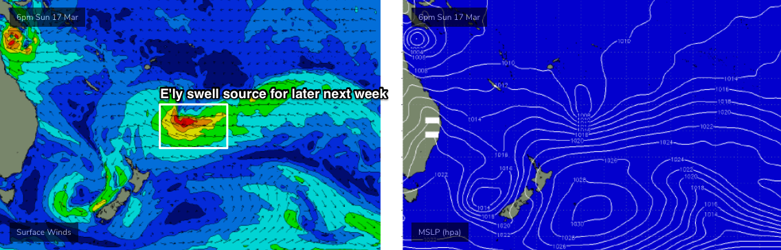
This will generate a fun E’ly swell event that’ll build on top of the slow inconsistent surf seen over the weekend (that'll persist into early next week) - we’re not looking at an arrival until about Wednesday of next week, but we’ll see surf size build more prominently into Thursday with set waves reaching somewhere in the 3-4ft+ range, holding into Friday morning before slowly easing. It'll be extremely inconsistent but should be a worthwhile event to work around.
Elsewhere a small cut off low in the Southern Tasman Sea early next week looks like it’ll be too weak and poorly aligned to generate any notable swell for us, though a minor flush of sideband S/SE energy can’t be ruled out across Northern NSW.
There are other sources still popping up on the long term synoptic charts (including that tropical cyclone in the Northern Coral Sea) but they still don’t look very plausible as swell sources for our region at the moment. But I’ll keep a watch and will update in more detail on Friday.
Comments
Plenty of small S'ly swell in Coffs (bodyboarder sitting in the pocket in image 3), every now and then a decent sized one stands up on the outer bar too (last frame) - that's gotta be 3ft+ at least?


*Yawn* How's this though: https://www.gizmodo.com.au/2019/03/the-central-us-is-about-to-get-hit-wi...
Ah yes, nothing like a "design, technology and science fiction website" running weather forecast articles.
Whatever gets the clicks, I suppose.
Sorry that wasn't yawn at your forecast, it was yawn at the forecast.
Yeah it's pretty much trash now but every now and then has something interesting.
Even worse: Gizmodo is one of the many acquisitions by Nine Entertainment (so, it's a subset of Pedestrian TV now).
Worse again: it's an Australian 'tech' site ("Gizmodo loves technology + entertainment"), running a weather forecast article.
About a developing weather system in the USA.
But, clickz.
So Ben when you say 2-3 ft on the weekend you are talking south of Byron? Not the Goldy?
There'll be a mix of swells, and the E'ly component should favour all coasts. Slow and inconsistent but fun 2ft+ sets or thereabouts.
Today was the first day that felt like an autumn/late summer morning.
Light SW winds, small fun Sth swell and the water seemed to clear up a bit over the last 2 days.
It's been a long time coming.