Another long spell of easterly swell, biggest early next week

South-east Queensland and Northern NSW Surf Forecast by Ben Matson (issued Friday 1st March)
Best Days: Stacks of E'ly swell ahead, biggest Monday.
Recap: We’ve seen steady E’ly swells around the 4ft mark at open beaches in SE Qld and Far Northern NSW for the last few days, a little smaller south from Ballina. Winds have been mainly E/SE but there’s been periods of light variable winds at times.
This weekend (March 2 - 3)
Today’s Forecaster Notes are brought to you by Rip Curl
It’s nice to see a relatively stable synoptic pattern with no major curveballs within striking distance of the coast.
And the good news is that we’ve got plenty of east swell on the way too.
A broad ridge through the Northern Tasman Sea will be our predominant swell source for quite some time. It’s expected to hold steady into early next week before weakening slightly, though a small trough in the Coral Sea (near New Caledonia) will develop around the same time and push towards our region, maintaining plenty of trade swell for the coast mid-week.
The general outlook for the weekend is steady, with a very slight increase from Saturday through Sunday. There won’t be much of a size difference overall, and without a defined swell front there won’t be a noticeable change in conditions either. So although surf size should hover in the 3-5ft range at exposed coasts all weekend, between early Saturday and late Sunday we’re likely to see wave heights trend from the lower end of this estimated range towards the upper end. That’s probably the only way to describe the swell trend for the next few days.
Winds will be much the same as they have all week. SE Qld will be closer to the ridge and thus likely to experience a little more strength out of the E/SE thru SE (compared to the Mid North Coast) but all coasts have the potential for periods of lighter, and possibly variable conditions. But for the most part it’ll be a weekend of waves best suited to the various regional points (though size will be smaller).
Next week (Mar 4 onwards)
Severe Tropical Cyclone Pola - currently Category 4, south of Fiji - will curve to the south-east and then east over the coming days, heading into the South Pacific and away from our region.
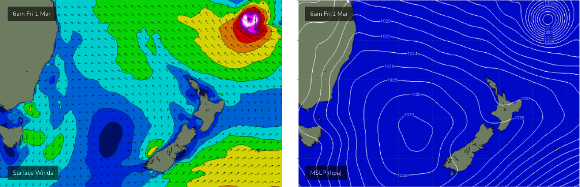
Although it’s a small system with a narrow core of the strongest winds, it is however interacting with a broad ridge to the south within our swell window and this will become a decent source of stronger E’ly swell early next week. Wave heights are expected to build steadily through Monday from this source, then easing slowly from sometime Tuesday onwards.
However, we have to be careful not to look at the model guidance in isolation, because it’s combining swell trains: the cyclone swell will be a short lived event in the middle of a broad, more sustained pattern of general E'ly swell from the ridge. So, background swell should manage 3-5ft for most of this period though we’ll see a kick in size at the height of the swell that could push another foot above this (occasional 4-6ft+ sets, probably late Monday or at a pinch early Tuesday).
As for the region likely to see the most size: because of the way TC Pola pushes south, there’ll be a small component of north in the swell direction and this will probably favour Northern NSW over SE Qld.
However, the ridge will be better aimed for SE Qld and so the underlying background E'ly trade swell will probably produce slightly better results north of the border than south.
Monday’s winds should continue the weekend’s trend across SE Qld though we’ll see lighter and more variable conditions across Northern NSW (south from Ballina) with light variable winds and sea breezes. Northerlies will develop across Northern NSW into Wednesday but this is unlikely to have any major strength in SE Qld (light and variable early, possibly a NE sea breeze into the afternoon). By this time the swell will be easing back slowly anyway, so make the most of Monday and Tuesday.
Long term has a shallow S’ly change into Wednesday, though with only a brief flush of associated southerly swell floor Northern NSW that will probably sit below the existing, easing trade swell.
Small trade swells are expected to continue into the long term, and a strong front and low is expected to cross the Tasmanian divide later in the week, leading to a more significant southerly swell for Northern NSW over the weekend or early in the following week.
More on this on Monday. Have a great weekend!
Comments
And.. we're up! Thanks for your patience, sorry about the delay.
Patience is a virtue ... save it for these damn devil winds !
Looks like autumn begins with a week long spell of ugly onshore gurgle.
I’m assuming that swell hasn’t done much to shake the banks up around Le-ba
Banks are diabolical to the point of unsurfable at some locations.
We've gone from shite banks to no banks.
I surfed the Pass yesterday arvo.
It's.......bizarre. Little bits and pieces of waves breaking on scattered rocky outcrops.
Never seen it so bad.
And crowded with hipsters moved up from Sydney in the midst of expensive Renos of old school beach shacks.
Fun and games.
Sounds horrendous.
Our banks are similar to that big shitty east thing early spring. I think they’ll recover reasonably quick though.
One spot that got a bit better too.
It's been an unusually long period of poor surf here, mostly due to the banks.
Climate change induced weather pattern changes which have not been conducive to this area.
Possibly climate change.... possibly a seasonal blip that could occur every couple of hundred years or so.... I’d like think blip due to a weird developing El Niño which has been threatening to form for the last 2 years... and likely to form through winter....but I’m no expert
Surfed the pot today, crowd was surprisingly good considering the festival of surfing was on. Few fun head high sets.
Been at Noosa all day for the event. Surf is pumping for longboarders.. ideal size, perfect conditions. Shoulder to head high sets at first point ain’t a bad thing if there’s only four in the water!
Re banks, there are some good ones around. Surfed one this morning on the central GC that barreled on take off and ran for 50-100m. Seemed to be peaks up and down the beach. Happy hunting!
Those onshore winds though...
Grubby out there today
A nothing day with no one out. Just a stray set from the S every so often.
Just posted up because it's been so, so long since I've seen anything resembling a nice clean peeling wave.
Starting to doubt they exist around here.
nice
fishing rod swapped for surfboard very quickly
EASTERLY SHIT.