Fun, brief NE swell for Saturday, plenty of swell next week

South-east Queensland and Northern NSW Surf Forecast by Ben Matson (issued Friday 31st August)
Best Days: Sat AM: clean mix of peaky NE and SE swells, biggest on the southern Gold Coast and far Northern NSW coast. Smaller elsewhere, and easing rapidly during the day. Mon/Tues: solid S'ly swell, though tricky winds. Good for Northern NSW points, though very small in SE Qld. Tues/Wed/Thurs: Fun trade swell in SE Qld with winds favouring the points.
Recap: Thursday was very large across some parts of Northern NSW, but the biggest surf (8ft+) seemed to be concentrated around the Mid North Coast’s south swell magnets, with smaller surf across the Northern Regions. And unfortunately, SE Qld came in at the lower end of forecast expectations with clean though inconsistent 3ft sets across the outer Gold Coast points, and infrequent 3-5ft sets across exposed northern ends (though conditions were nice and clean with light offshore winds), slightly smaller again across the Sunshine Coast. We’ve seen this swell ease into today though winds have strengthened from the north and there’s now 3ft+ of junky northerly windswell at some exposed spots.

Thursday morning lines at Currumbin
This weekend (Sep 1 - 2)
Today’s Forecaster Notes are brought to you by Rip Curl
Northerly winds will remain at strength for the next few hours, but a westerly change is due in the early hours of Saturday morning, and we’ll see a NW trend kick in prior to its arrival.
This pattern will shut off the supply of local N’ly windswell to our coast, which means we’ll see easing wave heights from about midnight onwards. However, there should still be just enough energy at dawn for some decent waves - though the alignment of the fetch and the approaching change (arriving earlier across more southern regions) reduces the swell potential for the Northern NSW coast south from about Yamba or Coffs because surf size will begin to ease here earlier.
Also, the Sunshine Coast has less upstream fetch (compared to other coasts) so we’ll probably see smaller size here too.
Maximum surf size is expected to be concentrated around the Southern Gold Coast, Tweed and Byron to Evans regions, which should see peaky NE swell around 2-3ft early morning at exposed north facing beaches. Expect a steady easing trend throughout the day - possibly mid-late morning.
However, remaining Northern NSW coasts should see residual 2ft+ sets leftover from the S/SE on Saturday morning, ahead of a similar easing trend. This swell will be much smaller in SE Qld because of the swell direction.
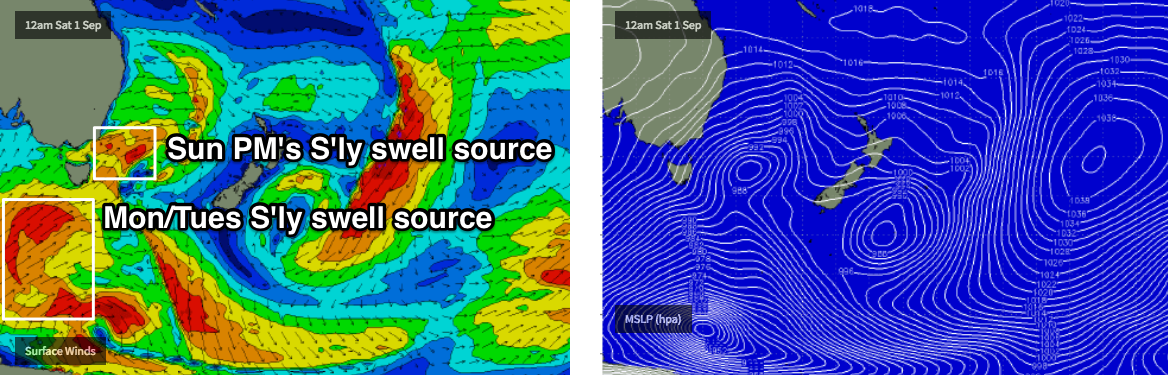
On Sunday, winds will freshen from the southern quadrant (SW early, tending S’ly then SE) as a change pushes up the coast. There’ll be a fair degree of southerly swell trailing the change - which is expected to peak on Monday or early Tuesday - but after an initially small start, Sunday afternoon’s increase will be bumpy at those (south facing) beaches (south of Byron) that’ll see the most size - perhaps some late 4-5ft sets at reliable south swell magnets.
As such, expect very little surfing opportunities on Sunday; protected southern corners will be clean but very small. You’ll have to make a compromise between size and quality. And in SE Qld, there just won’t be much size on offer.
Next week (Sep 3 onwards)
The front associated with Sunday’s southerly change will clear to the east into Monday, but a ridge will build across the coast and this will lead to a risk of moderate onshore winds throughout the day. The southerly groundswell should reach a peak throughout the day, originating from much further south of Tasmania over the weekend (see below), pushing 5-6ft at south facing beaches south of Byron, though much smaller elsewhere.
This swell won’t be very well aligned for SE Qld so we can expect slow 1-2ft waves on the outer Gold Coast points, up to a bumpy 3ft at exposed northern ends though smaller across the broader Sunshine Coast. Wave heights will then slowly ease from this source from early Tuesday.
The model guidance for the rest of next week is all over the shop. The broad synoptic pattern has chopped and changed a number of times over the last few days, of which the finer details revolve around a broad coastal trough. These systems often have a huge impact on the surf (size and quality) due to their close proximity to the mainland, so it's hard to have much confidence in the outlook at this stage.
At the present time, the models still expect some form of ridge will develop through the Northern Tasman Sea, extending to a reinvigorated low (responsible for Monday S’ly swell) off the NZ West Coast. This should maintain 3-5ft of SE swell across Northern NSW from Tuesday thru’ Thursday, with slightly smaller surf across SE Qld (more like 2-3ft across the outer points, with occasional 3-4ft sets at exposed northern ends).
Wednesday looks to be the day however this ridge will drive moderate to fresh E/SE winds at times, meaning the points will be your only option. Thursday will probably see the bets conditions but with a little less size. Again, confidence is low on this scenario.
It's likely that we'll see major variations in the models over the weekend as we have over the last few days, so these estimates will move around quite a bit. As such, I'll update in the comments below over the weekend as the models consolidate and we get a better picture on the outlook for next week.
Have a great weekend, see you Monday!
Comments
Hey mate just wanted to see if the current models which indicate the east swell with northerly wind is a likelihood for wed / thurs or if this is just models getting my hopes up?
No guesses where you're looking to surf ;)
Let’s just say Kings Beach hey.
Sorry mate, missed this over the weekend. The E'ly swell will probably reach a peak around this time but we won't see N'lies until Friday - so you'll have to content with E'lies most likely on Wed/Thurs. Not a great combo, but there'll be options at sheltered spots.
Size is building across the northern Goldy beaches now, here's a chunky 3ft+ set rolling through Narrowneck.
