Small easing weekend, fun E'ly swell next week

South-east Queensland and Northern NSW Surf Forecast by Ben Matson (issued Friday 29th June)
Best Days: Sat/Sun AM: small peaky E'ly swell in SE Qld and Far Northern NSW. Tues/Wed/Thurs: fun E/SE swell, smaller in SE Qld.
Recap: Fun trade swell has provided 2-3ft surf across SE Qld and Far Northern NSW over the last few days, with smaller surf south from Yamba (though there’s been a small SE swell in the water here). Winds have been generally light offshore, though we saw moderate N’ly winds develop on the Gold Coast this afternoon (elsewhere winds remained well under 10kts).
Today’s Forecaster Notes are brought to you by Rip Curl

Late peaky leftover trade swell on the Sunshine Coast
This weekend (June 30 - July 1)
Want to receive an email when these Forecaster Notes are updated? Then log in here and update your preferences.
Note: Today’s Forecaster Notes will be brief, as Craig is away on annual leave
There’s not a great deal of size or strength expected for the weekend, though Saturday will offer the best surf of the next few days with light variable winds ahead of a developing southerly change through Sunday.
The SE swell of the last few days is almost gone so we’ll be reliant on easing trade swell across the region. SE Qld open beaches should continue to see occasional 2ft sets, but south from Byron or Ballina it’ll be smaller. This swell will ease incrementally more into Sunday.
The southerly change expected on Sunday should be around Coffs or thereabouts around dawn, before reaching the border around mid-late morning - though we may not see a great deal of strength in Far Northern NSW and SE Qld until early-mid afternoon. In any case, there’ll be a window of small clean leftover trade swell in SE Qld ahead of the change on Sunday morning if you’re keen, just don’t expect anything amazing.
Otherwise, a small pulse of southerly groundswell may glance the Lower Mid North Coast late Sunday afternoon, but with tricky winds (in the lee of the southerly) it’s hard to imagine anything amazing.
Next week (July 2 onwards)
The small south swell slated for late Sunday in the Far South should push across remaining south swells magnets in Northern NSW on Monday. However, a developing trough off the Southern Qld/Far Northern NSW coast on Monday is offering good swell potential for the middle of the week.
Initially, Monday will see fresh southerly winds and mainly building short range windswells as the trough develops, but by late Monday an easterly fetch across the southern flank of the trough will become better established and we’ll see building E/SE (in the south) tending SE (in the north) swells across most coasts over the coming days.
Models are in agreement about the synoptic pattern but divergent on the specifics, so I’ll peg size anywhere between 3ft and 5ft across Northern NSW at some point through Tuesday and Wednesday (smaller across SE Qld, thanks to the fetch being focused south of the border, perhaps 2-3ft+ at the outer points?). I will refine this outlook in the comments below over the weekend as new information comes to hand.
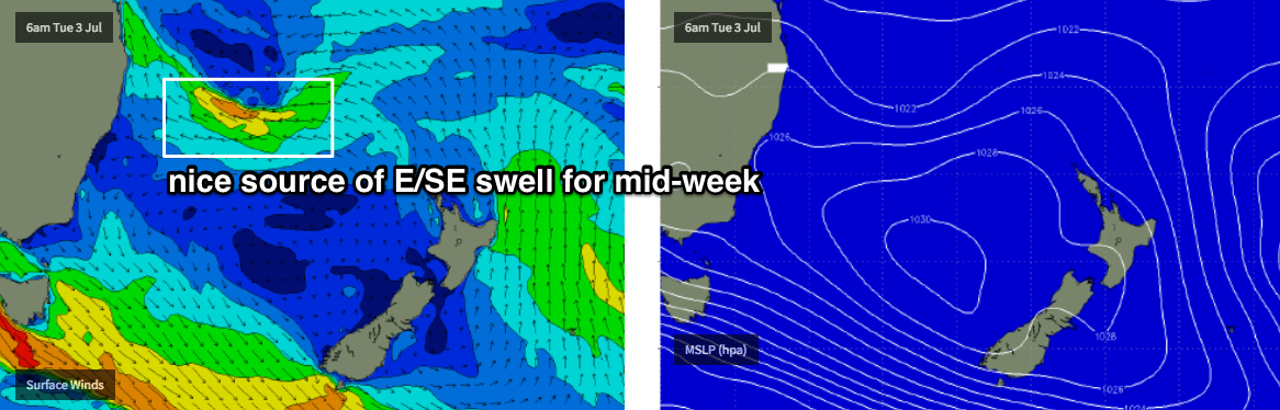
Either way, this suggests we’ll see some form of easterly swell through most of next week and probably into the weekend, as an anchored blocking pattern takes hold - ordinarily this wouldn’t be worth mentioning, except it’s much less common this time of the year - any east swell is a treat.
Elsewhere, the Southern Ocean is gearing up for an extended round of winter fronts through the Bight and this invariably puts the upper level steering winds on the wrong side of our southern swell window - pushing storm activity away from us.
The next round of significant activity probably won’t be until the Long Wave Trough slides east of Tasmania later next week and into the weekend, which will probably herald the beginning of an extended period of strong southerly swells (and windy conditions from the SW quadrant) through into the early to middle part of the following week.
That’s still quite some time away though, so let’s take a closer look on Monday. Have a great weekend!
Comments
Looking at the cams, how's all that sand at Snapper-greenmount on the lower tides?