Best now and tomorrow morning
Friday, 22 November 2024

Best now and tomorrow morning
Friday, 22 November 2024
The coming period looks average wind wise so make the most of this morning and tomorrow.
The coming period looks average wind wise so make the most of this morning and tomorrow.
Fun waves in eastern Indonesia and across selected spots in the Maldives.
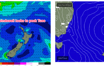
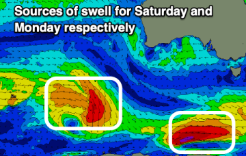
Good pulses of swell are due tomorrow and Saturday.
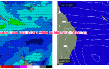
That will be the dominant feature of our synoptic set-up for some time, which sees high pressure in the Tasman and a firm ridge up the sub-tropical coast and broad fetch of E-E/SE winds in the Coral Sea.
There is quite a strong front tracking across the lower Tasman in advance of this high cell, along with a polar low, which will send some useful S swells our way before the high sets up a blocking pattern, which is expected to be reinforced by another large high next week.
A large but not especially strong (1029 hPa) high pressure cell is west of Tasmania and slowly moving E where it enters the Tasman and becomes very slow moving. That will be the dominant feature of our synoptic set-up for some time, with a classic summer wind signal of SE winds in the sub-tropics, tending NE through temperate NSW.
There is quite a strong front tracking across the lower Tasman in advance of this high cell, along with a polar low, which will send some useful S swells our way before the high sets up a blocking pattern, which is expected to be reinforced by another large high next week.
Give the end of the week a miss with the weekend coming in better (mainly for the South West).
The Mid Coast will bottom out as the South Coast provides the best conditions ahead of an average week next week.
The beaches will become much cleaner over the coming days but the swell will be on the edge of being too big and overpowering.