Fun swell for tomorrow morning
Monday, 30 October 2023
Fun swell for tomorrow morning
Monday, 30 October 2023
The coming period remains slow with slim pickings. The most size is due this afternoon and tomorrow morning.
The coming period remains slow with slim pickings. The most size is due this afternoon and tomorrow morning.
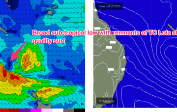
The Tasman low of sub-tropical origins which has sprayed the East Coast with swell is now just north of the North Island, with some swell generating winds still active to the west of the North Island, although quite limited in length. It’s deepened and is hammering the North Island.
We've got a large SW-S/SW groundswell on the way but with some decent size getting into the gulf.
The coming groundswell will mostly be spoilt by onshore winds though there'll be workable windows for the keen and experienced.
This swell energy isn’t well aimed for for CQ but the developing surface low is still strong enough to send swell north of Fraser Island.
Easing surf tomorrow ahead of a small S/SE groundswell Sunday. Stronger W/SW swell to fill in next week.
We’ve already seen solid S swells in NETas from the frontal system with smaller surf expected from the sub-tropical low system.
Make the most of the coming windows of swell and winds as the outlook otherwise remains average.
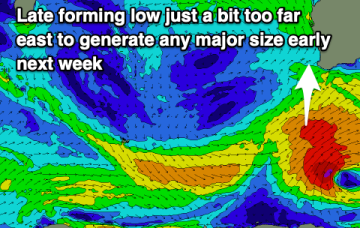
The evolution of the surface low in the sub-tropics is complicated and running a little behind schedule, but as we suggested on Wed we’ll see the remnants of severe TC Lola drift into and become absorbed into the large low centre over the weekend as it approaches the North Island.
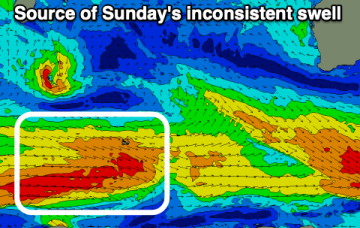
We’ve still got the building blocks in place for large swells across most of the Eastern Seaboard, with a large high , powerful frontal system, and deepening trough (still expected to form a surface low) in the Northern Tasman currently in play.