Plenty of swell with tricky winds this week
Monday, 15 May 2023
Plenty of swell with tricky winds this week
Monday, 15 May 2023
The windows of clean conditions down South will be smaller this week, though with plenty of size.
The windows of clean conditions down South will be smaller this week, though with plenty of size.
A good coverage of strong breezes in the Coral Sea has built a handy tradewind swell, biggest in SEQLD and favouring the Points.
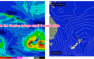
The front interacts with the trough to form a surface low off the North Coast but consistent with Fridays notes the surface low is expected to rapidly move away towards New Zealand later Wed into Thurs, with only a short spike in swell expected for temperate NSW.
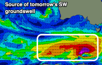
A strong swell will peak tomorrow but with poor winds, improving later week. Next week is much more promising.
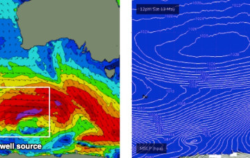
We’re just starting to see the first signs of new W/SW swell...
We’ve got a brief flush of W/SW swell for Saturday that will favour the open beaches east of Melbourne, before easing in size into Sunday.
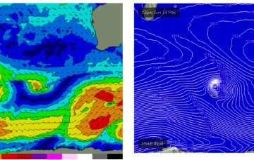
A weak front tips the SW of the state and brings an onshore W’ly Sat, tending SW on Sun, more SE in Perth/Mandurah. We’ll see some moderate pulses over the weekend, from follow-up fetches to tomorrows cold front
No swell sources for the weekend so we’re looking at tiny surf across the weekend with just a slight increase in minor S swell Sunday, no more than 1ft though.
Leftover S/SE-SE swell from the last stages of the fetch as it lingered in the Eastern Tasman abutting New Zealand should hold some 3ft sets through most of the day, albeit slow and inconsistent. Mixed in will be an inconsistent signal of E swell, not offering more than the occasional 2-3ft set.
Leftover S/SE-SE swell from the last stages of the fetch as it lingered in the Eastern Tasman abutting New Zealand should hold some 3ft sets through most of the day, albeit slow and inconsistent.