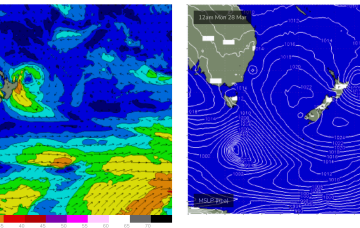
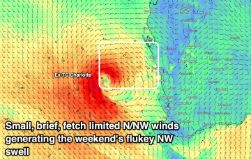
Poor outlook with a return of the sou-easters
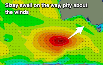
A good swell will be spoilt by a return of strong and gusty S/SE-SE winds. The Mid Coast will be clean but minimal in size.
OK, it’s going to be a wild week so lets look at the moving parts and sketch out the order of events, whilst acknowledging that it will be a highly dynamic outlook requiring fine tuning as the troughs, front, upper trough and expected eventual storm force surface low all interact.
An average outlook with poor winds developing, spoiling a moderate-large SW groundswell.
A much stronger cold front sweeps through Thurs, with size quickly ramping up from the S into the 3ft range.
This ridge of high pressure builds a fetch of Tradewinds through the Coral Sea over the coming 24-48 hrs and while the troughiness off the NSW coast disrupts the tradewind flow it should be sufficient in width and strength to see 1ft surf build later Sat, building further Sun into the 1-2ft range.
This expansive troughy pattern is likely to morph from day to day as weather models struggle to resolve the vorticity and local areas of low pressure within the trough line.
This is then augmented by a major front pushing into the Tasman, merging with the surface low to create a large area of low pressure in the Tasman.
Good swells and generally light winds with lots of surfing opportunities.
Nothing major over the weekend, with a small, flukey NW swell in the mix. Better surf potential mid-next week.
Plenty of swell energy but winds will be average for the South Coast apart from the weekend.