Lots of swell to come, cleanest down South on the weekend

South Australian Surf Forecast by Craig Brokensha (issued Friday March 25th)
Best Days: South Coast tomorrow morning and Sunday, Mid Coast Thursday
Features of the Forecast (tl;dr)
- New S/SW swell for tomorrow with light E/NE tending S/SE winds
- Reinforcing S/SW swell arriving late morning Sun with light N/NE tending variable winds
- Easing surf Mon with moderate S/SW tending S winds
- Weak S/SW swell Tue with light S/SE winds, increasing
- Mod-large SW groundswell for Thu with strong S/SE winds, easing Fri with E/SE tending S/SE winds
Recap
A good pulse of S/SW swell yesterday with 3ft surf across Middleton and cleaner conditions through the morning, workable into the afternoon. The Mid Coast held 1-1.5ft through the morning before pulsing to 1-2ft but with fresh sea breezes through the afternoon.
Today the Mid is back to 1ft with the South Coast bumpy and to 2-3ft.
This weekend and next week (Mar 26 – Apr 1)
The weekend is looking really fun for the South Coast as we see our slightly better pulses of S/SW swell filling in.
All this swell activity has been generated by a great progression of relatively weak but persistent polar fronts, generating fetches of strong to sometimes gale-force winds through our south-western and southern swell windows.
The final front in this progression is currently generating a broad fetch of W/NW gales south-west of Tasmania and will pass under their state today.
 The first pulse of S/SW swell should be in the water from dawn tomorrow with sets to 3ft to occasionally 4ft due across Middleton under a light E/NE morning breeze. It won't be perfect but should be fun across the Middleton to Goolwa stretch. The Mid Coast will only be tiny and to 0.5-1ft owing to the southerly swell direction.
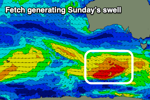
Sunday looks the pick still with a light N/NE offshore wind, tending variable ahead of possible late S/SW winds. Swell wise the reinforcing pulse of S/SW swell is due to arrive late morning and be there for the afternoon, so expect 3ft sets across Middleton in the morning and some bigger sets to 4ft after lunch.
 Monday will unfortunately be onshore with a trough moving through just before dawn, bringing a moderate S/SW tending S'ly breeze as Sunday's swell eases. The trough may bring a weak pulse of S/SW windswell Tuesday as winds abate temporarily though linger from the S/SW. In all respects another lay day.
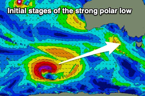
Moving into the end of the week, we're looking at a moderate-large SW groundswell generated by a strong polar low firing up south-east of the Heard Island region on the weekend.
The low will be initially strong with a fetch of severe-gales generated through our long-range swell window, with it weakening while pushing east and under the country early next week.
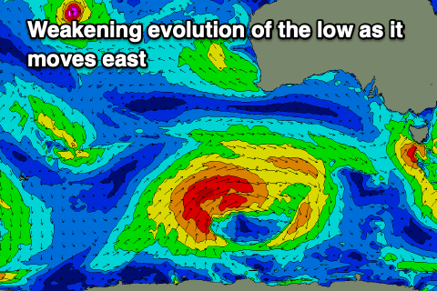 The swell should arrive overnight Wednesday and peak Thursday to 4-6ft across Middleton with the Mid Coast seeing 1-2ft sets on the favourable parts of the tide.
Unfortunately a strong high will move in behind a S/SW change on Wednesday (as a front from the low clips the state), with strong S/SE winds seen into Thursday. We'll likely see conditions improve slowly from Friday and more so next weekend as the high pushes east, swinging winds E/SE, then NE as the swell eases. More on this Monday. Have a great weekend!