Small weekend of waves; interesting long period E'ly swell next week

South-east Queensland and Northern NSW Surf Forecast by Ben Matson (issued Friday 19th August)
Best Days: Tues PM and Wed: new long period E'ly swell though N'ly winds may ruin surface conditions. Thurs/Fri: smaller E'ly swell with offshore winds for the beachies.
Recap: Small beach breaks have played out over the last few days. As suggested in Wednesday’s notes, it appears that SE Qld has seen a minor strengthening in the small east swell today (buoy data showing steady wave heights but a marginal increase in peak swell periods). Otherwise, Northern NSW has remained steady in size.
This weekend (Sat 20th - Sun 21st August)
No changes to the weekend outlook.
With no major swell sources developing in the last few days, we will be relying on small residual E’ly swells for the next couple of days. If anything, there’ll be a very slow easing trend all weekend, thanks to the trades slowly weakening from late Thursday.
This E’ly swell will be biggest across SE Qld and Far Northern NSW, with slow, inconsistent sets around 2ft+ early Saturday morning, becoming smaller throughout the day and probably levelling off around 1-2ft on Sunday.
South of about Ballina, we will see slightly smaller wave heights with a similar trend.
Winds look to be a little tricky this weekend too. A front moving across Southern NSW will bring about a W/SW wind change on Saturday to the Mid North Coast but N’ly winds ahead of this change will persist about the Far Northern NSW and SE Qld coasts for much of the day (they may tend NW at some point). So north of about Coffs Harbour you'll need to find a sheltered northern corner.
This is a pain as these generally unfavourable winds will coincide with the likely largest surf of the weekend.
As a new ridge builds in across the coast behind the front into Sunday, winds will swing SW thru’ S’ly then S/SE across SE Qld - not enough to generate any new surf, but enough to bump up the open beaches picking up the small residual energy. Aim for an early surf on Sunday to capitalise on the leftover energy and early window of sou'westers.
Similar winds will be experienced across Northern NSW on Sunday, though the Mid North Coast will see less strength, in fact light variable winds are possible into the afternoon. However with no major surf on the cards there’s not much to get excited about.
Next week (Monday 22nd onwards)
There’s lots of interesting swell sources lining up for next week. However, it has to be said that confidence is not high for many coasts, owing to a few reasons I’ll explain below.
A deep mid-latitude low is intensifying E/NE of New Zealand’s North Island at the moment, and it’s generating a fantastic long period E’ly swell for the South Pacific.
Unfortunately, most of the Australian East Coast lies behind the swell shadow of New Zealand’s North Island. This means that many coasts will see a smaller, diluted spread of swell from this source.
The only coastlines that are likely to pick up a decent amount of size is the Sunshine Coast, and to a slightly lesser degree, the Gold Coast. In essence, the further south you travel, the greater your chances of being inside New Zealand's swell shadow. It’s very hard to determine exactly where this ‘cut-off point' might be but I am expecting a fairly steadily drop in size south from about Ballina or thereabouts. This doesn’t mean tiny surf across the Mid North Coast, but it will ensure smaller, less consistent swell energy.
So, Monday and early Tuesday will initially see a small increase in E’ly swell, originating from the initial stages of this development. Exposed beaches in the north (i.e. SE Qld) can expect slow 2-3ft sets on the more favourable parts of the tide. South of about Ballina we can expect smaller surf.
Winds look a little funky on Monday and Tuesday with the early stages of a developing coastal trough likely to result in some form of northerly. So keep your expectations low unless you have a reliable, sheltered northern corner. Early morning should offer the best window of conditions.
Stronger, long period E’ly groundswell is then expected to arrive around lunchtime on Tuesday, with peak periods expected to be up in the 15 second range. This should boost wave heights across most coasts mid-late afternoon, holding into Wednesday morning before easing slightly into the afternoon but still holding a reasonable size range through Thursday, and maybe even early Friday.
The peak of this swell - possibly as early as late Tuesday, but also through Wednesday morning - should see inconsistent 3-5ft sets across exposed parts of the Sunshine Coast, and 3-4ft surf across the Gold Coast. South of the border, wave heights will start to tail off but I think Far Northern NSW should still see 3-4ft sets down about Ballina with smaller surf then across the Mid North Coast (say, 2-3ft?).
However, I’m not especially confident in these size estimates so focus in on the swell trend and the wind rather than the specific surf size. And due to the very large travel distance, set waves will be very inconsistent.
The problem with this swell event is that the developing coastal trough will occupy the region at the same time the swell is peaking - so Tuesday afternoon and Wednesday are a risk of being spoiled by northerly winds. At this stage no great strength is expected but what it means is that the regional points will probably be bumpy, so you’ll have to pick your windows across the beach breaks in and around isolated pockets of NW breezes. I’ll be able to identify these windows in more detail on Monday.
As the coastal trough moves off the coast later Wednesday and into Thursday, winds will swing fresh W/NW, which will favour the beach breaks with clean but easing, inconsistent E’ly swell to finish the week. We’ll probably trend down from an inconsistent 3ft to 2-3ft across SE Qld during this time with smaller surf south of Ballina, but local banks pending, this should be a good window of waves for most beach breaks.
As for other swell sources - the deepening coastal trough from Wednesday onwards looks like it’ll favour Far Southern NSW and Tasmania with a solid E’ly swell mid-week. At this stage I’m not expecting any swell for Northern NSW or SE Qld but I’ll update these thoughts on Monday.
Otherwise, a bombing low in the Southern Ocean (mentioned in Wednesday’s forecaster notes, that’s expected to generate epic waves for Vicco this week) will weaken and then traverse our far southern swell window on Sunday. The only region of interest is a small embedded polar low around 67S, 157E on Sunday afternoon. The associated fetch looks good but it’ll be tracking eastwards - perpendicular to our swell window - so that factor, plus the large travel distance, significantly reduces its swell potential.
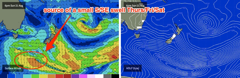
Long period S/SE swell is expected across Northern NSW from this source from around Thursday through Saturday, but it’ll only favour exposed south swell magnets with very inconsistent 2ft to maybe 2-3ft sets. Don’t get your hopes up from this system.
So, lots to look forward to next week. Have a great weekend; see you Monday!
Comments
Yep, it's windswell shore breaks with cross shore / onshore northerly winds this morning. Another good day to rest the shoulder ...
I'm keeping expectations very, very low for next week.
Banks are still a mess down here.
Sensational,peaky 3ft beachie wedges up north this morning!
2nd that.
3rd that, ramp city where I was.
Awesome.. Great to hear!
Scored some amazing shaped, if only small beachies on the lower Mid North Coast yesterday. Just 1.5-2ft but incredible little barrels right on the shore.
Looks like ya in my old territory Ben?
Watch them shallow shories, they have a tendency to impart shoulder and hip injuries. Sand can feel like concrete sometimes... but, then again, after nursing such an injury for a few days, turns out 'twas nothing of the sort. Rather, the early stages of shingles - got the rash overnight, doc confirmed diagnosis this morning.
Gday Ben,
How come the 5 day forecast isn't showing any of the groundswell (3-5ft) mentioned here in your notes ?? Or have the models changed since Friday ?
Hoping its on its way