Small E'ly swell this weekend; interesting options in the long term

South East Queensland and Northern New South Wales Surf Forecast by Ben Matson (issued Friday 4th March)
Best Days: Sat/Sun: small new E'ly swell with variable winds (light/variable early, mod onshore from late morning). May not be in the water at dawn Sat though (so be patient!). Most of next week should also have waves though it'll be a little patchy at times. Chance for a return to better surf later next week and the following weekend.
Recap: Small weak SE swells with light variable winds tending moderate onshore. Totally forgettable both days across all coasts.
This weekend (Mar 5th - 6th)
We’re still on target for a small fun pulse of fresh E’ly swell Saturday morning. This was generated by a modest fetch that developed just north of New Zealand on Wednesday and Thursday, and although not overly strong, it should certainly provide a lift from the lacklustre short range energy that has dominated the past five days.
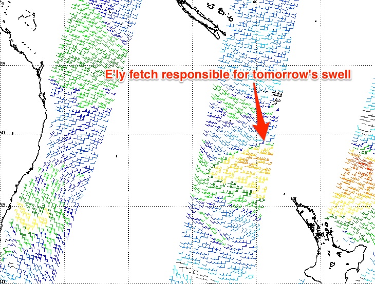 At this stage the leading edge is expected to push through shortly after sunrise. As such, I don’t think dawn will reveal anything notable in the surf department, but by early-mid morning it’s possible that some of the more exposed beaches around Far Northern NSW will start to see building energy, and by lunchtime most open stretches should start to see peaky 2-3ft waves, holding into the afternoon.
Reliable swell magnets in Far Northern NSW should push slightly above this into the late afternoon, but we’re looking at a slowly easing trend throughout Sunday - the early morning may offer a similar size range as per late Saturday but it will certainly become smaller throughout the day.
Expect smaller surf across the various points; there won’t be a lot of push in this swell so exposed beaches will certainly be your best choice.
As for local winds - I'm not expecting much change to what we’ve seen in recent days - an early light variable flow tending offshore, before a mid-morning swing to some form of onshore (probably SE thru’ E/SE) of moderate strength. So mornings will offer the best waves but there’ll be workable options into the afternoons too.
Next week (Mar 7th onwards)
As per the forecast notes issued Wednesday and Monday, there are still no significant features expected into the longer term.
However, large swells are not a crucial ingredient for good surf in this neck of the woods - the key to scoring decent waves is to look for small bumps in swell energy, that coincide with periods of favourable winds.
To that end, we have a couple of interesting weather systems that I’ll be keeping an eye on for next week. To quickly summarise - we’ve got a blocking pattern across the Tasman Sea at the moment, with a stubborn high and a weak trough of low pressure across the Coral Sea.
The fetch that generated tomorrow’s E’ly swell has been lingering about Northern New Zealand for the last few days, and a small easterly dip contained within is expected to retrograde westwards. This sounds a little more exciting that it actually is (wind speeds won't be terribly strong), however in the absence of anything notable, it’s worth keeping an eye on as these small westward tracking easterly fetches can sometimes punch well above their weight.
Right now the models have this easterly dip fizzing out before it gets too close to the mainland, but prior to then should have generated a small renewal of E’ly swell that’ll lift surf size from later Monday thru’ Tuesday and Wednesday across Far Northern NSW and SE Qld. At this stage set waves should hold in and around the 2-3ft range at exposed beaches (maybe a little smaller on the points, and south of Yamba) but let’s take a closer look at this into Monday.
The other area of interest is a stationary trough off the Northern Qld coast, which - in conjunction with the Tasman high - extends a broad ridge out into the Coral Sea. The squeeze between the two is expected to moderately strengthen from Sunday onwards.
Initially, this strengthening looks to be mostly a piecemeal effort with no consistent form of consolidation. So the surf potential is somewhat patchy from this source at first.
However, the is a suggestion within some of the models that we may also see another easterly dip form west of New Caledonia early next week. The reason this is interesting is that (1) an E’ly dip will tighten and focus the fetch (slightly stronger, more consolidated), and (2) it’ll also swing the fetch around to the E/NE - aimed into our general neck of the woods.
The other favourable synoptic feature is that the overall blocking pattern looks like it’ll remain in place. So whatever strengthens in the lower Coral Sea will probably remain slow moving for a considerable period of time. And this is great for surf production on many levels, especially if the fetch remains just offshore so as to not greatly influence local winds. We can often see an extra 20-30% out of a stationary fetch - even if just at 20kts - than that of a migrating system.
So, this is still quite some time away but right now it looks like the second half of next week will see a slow but steady increase in E/NE swell, bigger on the Sunshine Coast with sets in the 4ft range by later Thursday or Friday (smaller south of here, especially so south of Ballina or Yamba).
And if all goes to plan and the block remains in place (and the easterly dip maintains strength), we could see a continual slow increase in size throughout the following weekend, holding into the adjoining week. I wouldn't be surprised if next weekend ended up producing 4-5ft waves across SE Qld beaches and 3-4ft surf on the points. But that's going out on a limb right now; there's a lot that needs to come together between now and then.
So, it's nothing amazing to pin your hopes on just yet - but the longer term trend certainly points towards a small but sustained, and most importantly - slowly building trade swell. Which is always a bucketload of fun around here.
Have a great weekend, see you Monday.
Comments
Righto. Here's to a few fun peaky beachies this weekend, y'all.
Swell looked nice in Ballina this evening, just needed the onshore to cease. Looks like the banks are quite far out after Winston though.
Great work once again Ben. Most of the jargon flies straight over my head but still the best forecast for me to plan my days around.
Been a few lumpy ones around sunny coast.love the bog standard trade swell .wind's a problem into the future tho,for the beachies.easterlies been into it early
Yep the persistant onshores are a pain. Almost better windows through the middle of the day rather than the early. They persisted late in the season last year as well. Wont be long before Don is blowing up.
Hello Autumn.
Hey mate, long time reader and sometime contributor to your forecast notes and forum. Can you please ask your web developers to add your forecast notes to the Swellnet App as I am continually opening up safari to access your posts every Mon, Wed & Fri. As for the conditions on the Sunny Coast very grovelly but good to get wet! Thanks Champion. Still can't believe they left you off the App!!
Had another look at the charts today.. Just to recap;
27th feb I wrote;
" long term, quickie will be praying to huey that the low above new cal around the 13th eventuates...."
2/3 I wrote;
"Well, long term charts still have something brewing around there, with a fairly strong high ridging against it..... So still a glimmer of hope the comp' wont be totally void of meaningful surf..... It sure isn't in the winston category..... More of a dip/trough... But looks like a decent fetch.... So it's a region worth watching over the next few days... Time will tell.."
Heck of a lot more confident now....... Some charts even have this above mentioned dip turning into a low just south of New cal, and heading wsw!! So I'd consider dusting some early rounds on the 12th/13th/14th, with a 7am start time to utilize lighter winds, prime time USA, and the fact that the late morning high tide on those days is quite a weak high tide ( around the 1.2 to 1.3m region)..
That will open up the possibility of holding qf's, semis and final in good 4 foot plus point surf in the following days.
Fun waves at sawti
Super fun beachies on offer today around lunchtime, very light onshore and peaky 3ft sets with the odd bigger one. Completely empty too. Stoked!
Yeah few around northern section sunny coast ,nearly glassed out late arvo, only 2,3ft up this way,nice to find plenty wave not to many punter , quite long period swell mixing in with the wind waves touch bigger than yesterday
I think WSL/quiky might be hoping for something in between GFS/EC. Latest EC not painting such a great picture with strong onshore winds and potential bank buster conditions.
yeah, that New Zealand source was definitely stronger Sun than Sat.
Can't believe Sheepdog hasn't come in with the jellyfish shitwind call. Last week was a textbook case.
Only been 1/2 paying attention, fr..... Few pc dramas and some non surfing issues to deal with.... What I do know is my bread and butter eastern window is looking like kicking in for another round of consistent wave action. Not only the new cal dip I've been waffling on about for ages now, but a potential system further out.... A new phrase could be "active seatstateitis" lol
So the Quiky Pro is about to start with possible consistent but small swell. The MJO is not predicted to return to our neck of the woods until mid March. So we've got a contest running that missed the brilliant run of swell.
How often has the Pro run during the best MJO cycle?
Dunno about "small", fatjack.... Goldy doesn't handle "large" anyway... When I say large I mean 12 foot......
What's your definition of small?.... There's a 50/50 chance of 4 to 5 foot east swell re' developments around New Cal and Fiji..
SD, whilst not a swell producer at present, what's ya thoughts on this possible long term inland low around the NT/Qld border right at the end of the model runs......if that thing slides out into the Coral Sea towards mid March!!!
I'll check it out....
2-3 foot is small. There's a 50% chance of a pulse of swell. And a 4-5 foot east swell might only be 2-3 foot on the points.
That's a nervous forecast for a combined men's and women's contest to get good waves for the majority of heats.
If the MJO was in cycle those trades - irrespective of a cyclone forming - would create a sustained fetch across the entire comp period. Exactly what we saw in the past month until Winston decided to go walkabout and thump the coast.
Irrespective of the discussion on small and big. I'm more curious of the alignment and choice of mid March as the start period and not late February. It might be selective memory but I seem to recall month long reports and imagery of great Qld swells on great banks every year and then the Quiky Pro starts after a cyclone in a chopped up bank with small waves and the occasional spike.
Well last year was early...almost 10 days earlier....Feb 28-Mar 13 and 2014 was Mar 01-12. And I don't believe they got any good swells throughout the last two years?
I would think it's near impossible to pick a comp date 6 mths out on a schedule and nail the MJO. MJO forecasts are not even accurate for anything 30-40 days out.
There's still ALOT of wiggle room in the long range models. GFS is slowly but surely aligning with EC and the latest EC has that small low retrograding westwards making a b line straight for Snapper so I'm with SD....there should def be very contestable waves midway through the waiting period if these charts come to fruition. Not too mention some possible TC developments in the SPCZ very late in the waiting period......but these charts are way too far off to have any real confidence.
http://www.ecmwf.int/en/forecasts/charts/medium/mean-sea-level-pressure-...
I'm sure there's a honours thesis or PhD - long term analysis of cyclic beneficial weather patterns to improve the probability of the Quik Pro being held in favourable conditions - including a mathematical model.
All for the benefit of improving the probability of good waves for surf comps. Back in the heady days of the uber rich big three you could've snaffled some good grant money for that work and justified field trips everywhere.
It's impossible to pick the right two-week window for any surf competition well in advance. I don't care how good the historical data might be, it simply has no bearing on whether your chosen window will actually score good surf (unless you are comparing the probability of surf between February and September, for example). This theory has been been tested numerous times by the ASP and the WSL over the last ten years (of which I have personally been consulted on a couple of occasions), and every time they seem to end up worse off than before.
Mother Nature is a fickle beast
yep, compared to last year this one looks pretty good.
all things considered the late Feb/Mar window has been very productive for the QuikPro.
They've suffered from too much swell as much or more than too little swell.