Large E'ly swell Saturday, easing thereafter

South East Queensland and Northern New South Wales Surf Forecast by Ben Matson (issued Friday 26th February)
Best Days: Potentially too big for all but the most protected locations on Saturday; otherwise excellent point breaks through the weekend and early next week before the E'ly swell dries up by late Monday or Tuesday. Nothing great on the cards beyond that.
Recap: Pretty stoked to report that the surf has panned out very close to expectations. Most of Thursday saw residual E’ly groundswell in the 4ft range at open beaches with mainly light winds, freshening from the NE in the afternoon. Very close to dark, some parts of the Gold Coast and Far Northern NSW Coast reported rogue bigger sets from a new pulse originating from (now ex) TC Winston, however we’ve seen a more pronounced increase throughout today with early 5-6ft sets pushing 6-8ft at most coasts throughout the day, with the exception of the Sunshine Coast which seems to have come in a little smaller (this is also supported by buoy data - the Tweed buoy showing the largest Hsig values of the entire SE Qld and Northern NSW region). Some locations are reportedly pushing north of 8ft+ this afternoon, though this appears to be confined to the Far Northern NSW coast (which was noted in Wednesday’s forecast). Winds were slack and/or variable in most regions early morning but moderate sou'easters have cropped up this afternoon.
This weekend (Feb 27th - 28th)
No major changes to the forecast notes from Wednesday and Monday.
Despite today’s new swell being inline with forecast expectations, there’s still a degree of uncertainty as to just how much more size we will see on Saturday, and exactly when it will reach a peak.
This is due to a lack of observations in our eastern swell window. As I have previously discussed at length, with our coastal buoy network located less than 10km off the coast, and buoy data often lagging by at least several hours (from data acquisition to web display), often the first signs of a swell trend - up or down - is via the surfcams, or human reports (thanks everyone for their input in the last few Forecaster Notes too, it is greatly appreciated).
Easterly swells are much different to southerly swells, which can be tracked as they move northwards along the coast. What I wouldn’t give for a buoy off Norfolk Island, Lord Howe Island or Middleton and Elizabeth Reefs…
Nevetheless, let’s take a look at the specifics. TC Winston dropped to below cyclone strength yesterday though it’s still quite strong, showing 30-40kts within our swell window for the last few days. And crucially, it is tracking westward - towards our coast - as a captured fetch. This enhances swell production and thus increases the size and strength of the resulting swell. Which is of benefit, if you’re looking for big surf.
If we simply use the wave model guidance as a tool to predict tomorrow’s surf, it suggests we’ll see increasing swell heights AND increasing periods. But, there’s some funky data in the mix that requires close scrutiny.
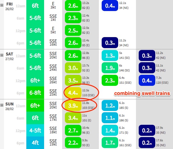 The image to the right shows the Gold Coast forecast points. Ignoring the “surf height” for now (first coloured column), we can see that the “primary swell” increases from 2.6m at midnight to 4.4m at 6pm. That’s a whopping increase from today.
At the same time, the period increases from 12.8 seconds at midnight to 13.7 seconds at 6am. That’s the swell front, of the next E’ly pulse from TC Winston, that I’ve been discussing all week. Although the numbers are a little unsure (i.e. today’s swell period forecast was mid-12 seconds, yet peak periods recorded at the buoys were 15 seconds), I don’t doubt the timing and the suggestion that it will increase from today.
The take home message: expect a larger swell period on Saturday, which means more size and strength, and also a greater magnification in surf size at the various reef breaks.
But the wave height increase is false. Why? Well, let's start by looking at the accompanying wind forecast. You can see that overnight, we have a gusty S/SE flow developing: 16kts at 6pm today, 20kts at midnight and then ~25kts for most of Saturday.
Consequently, the forecast models predict an increase in S/SE windswell throughout the day - just 1.9m @ 6 seconds at 6am, then 2.3m at 6.4 seconds at 12pm.
But where is the windswell value at 6pm? It is missing, because the swell models is struggling to resolve the individual swell trains, and it’s combining the S/SE windswell and the E'ly groundswell together.
You’ll also note that the swell direction for Saturday’s 6pm value swings 14 degrees south of east (96 degrees at 12pm to 110 degrees at 6pm). This is another red flag, and another by-product of the model combining swell trains. There ain't much we can do about the global wave model producing superious data like this.
So the take home message here: don’t trust the model’s size increase.
This is a small part of the methodology employ when looking at swell data - always question why it has increased. Does it make sense? Is there something else that could have contributed to the swell increase? In this case, the answer is yes: local windswell. And we're not interested in surfing that.
Getting back on track (hopefully you’re still with me!) - we should see a further kick in size from TC Winston on Saturday, though most of the increase will be period related - we'll see a strong increase shortly behind the swell front. Also, I suspect this next round of swell will peak through the morning and trend steadily down throughout the day.
Fresh S/SE winds from Coffs through to the Sunshine Coast will limit the best waves to the protected points, though with a lot of size on offer they’ll offer the only rideable options anyway. There's a chance for a brief window of lighter SW winds but this will probably be confined to the southern Gold Coast.
How big? Well, after holding steady with my call all week, I can’t find any evidence to downgrade previous outlooks. I still believe that the peak of this swell will be confined to the Far Northern NSW Coast (between the Gold Coast and about Ballina, maybe Yamba at a pinch), and well positioned reefs and other appropriate swell magnets could be looking at occasional 10–12ft bombs. Obviously, as your surf spot offers more protection, wave heights will become much smaller. But we’re still on track for a very large E’ly pulse.
As this peak is expected to have a narrow focus, I am expecting smaller surf across the SE Qld and Mid North coasts (early peak around 8ft, maybe 8-10ft at exposed spots, quite a bit smaller running down the points). So all in all, I can see this swell only benefiting a small number of locations that can actually handle the size.
Into Sunday, surf size will continue to taper off steadily from Saturday afternoon’s trend. However there’s one interesting aspect in the life of ex-TC Winston worth pointing out - as it draws close to the mainland tonight, it’s expected to momentarily restrengthen an E’ly fetch about its southern flank, aimed into SE Qld and perhaps Far Northern NSW on Saturday morning (though I am favouring the Sunny Coast).
This should generate a new secondary pulse out of the east for Saturday night or perhaps Sunday morning - keeping early sets in the 6ft+ range at exposed beaches, before easing throughout the day. This pulse won’t be quite as noticeable south of about Ballina, so expect a more linear decrease in size throughout Sunday (though still solid, maybe 4-6ft early, down to 3-5ft into the afternoon).
The point here being that some of the Sunny Coast’s protected locations haven’t fared very well during recent E’ly groundswells, but if I had to hedge a bet, I’d be very interested to see whether Sunday morning’s pulse delivered better results than Saturday’s longer period E’ly renewal. Because I think it may very well be the case.
After that, expect surf size to taper off slowly into Sunday afternoon.
Quickly on Sunday’s winds - very similar to Saturday though a little less strength. And probably a reasonable window of early SW in many locations too. So, the outer points should have excellent large waves on offer, with quality smaller surf at protected locations.
All in all, what a weekend!
Next week (Mar 1st onwards)
Jeez, after all of that next week looks like a big let down. But there will be waves.
E‘ly swell from TC Winston will ease rapidly through Monday and Tuesday. We’ll see small to moderate mid-range SE swell, originating from a stationary ridge that’ll extend north-west from the central Tasman Sea to the Northern NSW coast, but the accompanying winds will render exposed spots bumpy. So don’t get your hopes up for any quality. We're probably looking at a spell of small surf throughout SE Qld as a result too, though local winds will be more favourable here.
A couple of big beefy fronts and lows tracking through the Southern Ocean may briefly move into the Lower Tasman Sea, generating some new S’ly groundswell - the first (passing through that swell window now) looks too zonal (west-west) in structure but we’ll see some small sideband energy from its more southern developments early in the week.
A second, more favourably aligned polar low to the SW of New Zealand will generate a better pulse mid-week but at this stage I don’t think we’ll see much more than occasional 3ft sets at south facing beaches, around Wednesday.
Otherwise, there’s nothing of any major interest - a couple of minor fetches showing promise in our mid to far eastern swell window but nothing to warrant close scrutiny right now.
Make the most of what’s in front of you over the coming days. And please take care out there; we have a lot of water moving and it’ll be very easy to find yourself in a lot of trouble if you’re caught unawares.
See you Monday!
Comments
Hope y'all got through that, I'm exhausted from writing it.
It's appreciated.
Very nice forecasting thanks,GFS nailed it pretty good from way out.3ft but unreal at ...... .. pt. Pity the poor sand crabs,and sea birds.....never seen so many fwd warriors.
" unreal at ...... .. pt."
FFS mate!
Well I did say 3ft...Mate.thats all it was with 150 punters. .
And that was more in the spirit of informing on the swell size getting in up this way...Are you an angry man?
Not at all Spider,
Just giving you something back in return, whilst telling some bloke to fuck off about posting a photo.
Sorry for the late reply champ but been busy travelling catching waves in this once in a decade swell, hahahha..
Fair enough then,thanks for the reply,hope you got some good ones.i agree that was a silly remark.
Well done ben , I didn't know about that , inexperience had me thinking that it was gunna get way bigger tomorrow
Reckon there's any chance of a lighter sw or even S'ly flow for Ballina early?
Yeah should be a reasonable chance.
Long time reader rare commenter. That was an excellent run down. I have often wondered about nodes and anti-nodes when there are conflicting swells in the water. I think you just explained how the models can't really deal with this and that is rather than seeing the nodes we see two swells with sets from different directions .
Did that make sense?
Great read, always learning something in these forecasters notes.
Was at snapper today watching waves smash into the rocks from froggies and saw a wave propel a half metre rock 2 stories (height reference thanks to scaffolding) into the air right about where old mate usually plays the didgeridoo. Impressive displays of power everywhere today
Also saw a guy get smack into the Kirra groin as well. Yikes!
Checked a certain point inside a point inside a point somewhere north of peregian springs just b4 dark.... certainly picked up! Swells finally swingin round enough....solid lines. Cant wait for tomorrow.... gonna b boiling.....boiling hot!!! Yewwwwww.
Home boys sending pics to me of the insane sesh had by 10 of the lads.... Thanks..... Cunts..... lol..... Rumor has it some guy named Mick F made a cameo and got pitted off his nut..... bahahah ;)
Anyhoo Timmy B'.... Sorry to hear about the torn acl..... Fuckn bummer bro...... Thanks for the pics mate....
Nice pic SD looks soild.
By all reports it was, chase.... Picks up most swell... And it's not a pussy wave like kiddie park.. You still heading to ***?
How's the cunt about to drop in .... QLD's fucked . Ten guys you say . Consistent swell and still they fuck it up . . .?
Hey Ben. Longtime reader. I gotta say mate, You are pretty spot on, most times. You definitely show how hard it is to predict perfect big swell and light winds, degrees, intervals,period etc. I love Bathymetry and how swells line up towards a coastline. Dunno how people surfed 3 ft when I reckon Kirra had 8 ft bombs breaking as far out as the Reef. Its big when they come. Be careful. After 10 whitewash closeouts, all over red Rover. Anyhow, amped from today. Good luck to everyone tomorrow. Gonna take lots of energy. Yeew!
Wow.. Tweed buoy has dropped significantly overnight, no sign of the next pulse, yet. Other buoys have a less noticeable drop but period data certainly suggests early morning will be well under yesterday.
Could be one of two things: (1) next pulse swell is running late (remember, next swell from was expected around dawn) or (2) I've buggered up the timing and Friday was the main peak all along.
Argh!
Mooloolaba has increased though. Any ideas on that one Ben?
Winds swung SE yesterday evening and have been strengthening all night. It's currently 35kts gusting 43kts at Moreton Island (slightly upstream from the buoy).
The "increase" at the buoy is all windswell, as described in the notes above - though it's a little earlier than the models predicted.
http://www.bom.gov.au/products/IDQ60901/IDQ60901.94594.shtml
The Tz value ("average swell period" or "zero crossing") also gives it away. Tp ("peak swell period") is holding steady around 15 seconds - which is fine - but Tz is dropping as yesterday's groundswell is now "contaminated" with this building windswell.
Ben
Just a note on the Cape Moreton wind obs. After many years working around the Cape, you can generally knock 8 - 12 knots off the Cape Moreton obs compared to at sea level once it is recording more than 22-25, more once it blows harder.
Absolutely. 15% has been my rule of thumb here, and also several others (i.e. Cape Byron) due to their elevation and exposure. Cape Moreton also doesn't have any continental influence either so whilst it's useful to represent the broader synoptic airstream, it certainly doesn't have a lcose relationship with the nearshore winds of the Sunny Coast.
Same at the Brisbane buoy. Surf size continues to slowly lift with the addition of local windswell, but Tz correspondingly drops.
The size increase hasn't occured at the Gold Coast and Tweed buoys - despite a concurrent decrease in Tz - probably because the windswell fetch is more S/SE, so there's a greater degree of continental shadowing (confirmed by wind obs from Cape Byron and the Gold Coast Seaway, which show overnight winds to be more S/SE, even S'ly at Byron).
Regardless, Friday's swell has certainly dropped - and that's no great surprise, because Saturday's swell is a brand new pulse that'll be characterised by a kick in Tp once the new swell front arrives - but there's simply no sign of it yet.
So, I wouldn't write it off just yet. It's only early days.
Late yesterday afternoon, Tweed Bar looked more like a open beach break than a deep water river entrance:
That pic would have coincided with the peak of the swell per the Tweed Buoy data, pic was taken about 6.30pm AEDT:
And, in other news ... more public money was wasted by the clubby wankers, who, despite numerous media reports, failed to heed the advice to 'watch out for surging water and waves' ...
Idiots.
That pic was from yesterday morning around 10am AEDT
Ha, imagine how puffed up and righteous they'd be if that car belonged to Joe Public.
Hang on, am I being puffed up and righteous??
Just did a loop of carpark and all back streets at Noosa. People walking nose to tail from the town. Going home. Fuck that. Makes me grateful I'm not a mon-fri 9-5'er. Have fun people.
Shit! How's the size and energy at Byron - way bigger than the Gold Coast. I haven't seen the Byron cam showing sets breaking a couple of hundred metres off the Pass like this before.
Buoy data suggests the swell has dropped, but this random still image makes it look pretty big still. Hmmm.... maybe this is the leading edge of the new swell?
Maybe it's that spike in H max
That was three hours prior though.
And it's a classic illustration too - currently 7am here but the latest Byron buoy data is 3am. Anything could have happened in the last four hours but surfcams are the only way to know in real time.
Looks like the set hit Caloundra too :p
Ben, there is an interesting trend on the mhl data showing coffs had more size yesterday but Byron then started to kick last night. Although as you said the data is delayed.
I'm still suss on MHL data at the moment, so it's had to draw conclusions. Very annoying!
it's weird here this morning.....looks smaller.....I mean way smaller then every 20 minutes there's a 10ft set.
Way too raggedy and wide to surf though with the S'ly tearing it to pieces....damm, looks like yesterday was it.
Kirra is smoking!
Let's wait until the day is out and then see
Hey Ben i can't watch any surf cams any one else having problem this morning ?? To many trying to view???
Not working here either: black screen on all cams
We are experiencing extremely high traffic loads (early indications suggest one of our biggest, if not the biggest ever) so we're trying to free up resources and get things working more smoothly for everyone. Sorry for the inconvenience.
nice problem for you to have I reckon!
All working fine here. We are experiencing high traffic but the cams are working well at my end on a standard ADSL connection.
Thanks Ben.
Just got a chance to pop down to the beach and check the surf myself.
For my eyes, it looks the same size if not a tad bigger than yesterday afternoon. Easy 8ft sets on the Tweed Coast, possibly closer to 10ft at exposed spots but very unruly with the southerly wind chop/swell in the mix.
Honestly can't tell if it's a mix of two swells, leftover energy from yesterday or a brand new E'ly swell. But regardless - there ain't anywhere around here to surf today. Too big, and too much water moving.
Just checked the Bay , solid, way way bigger than yesterday arvo.
Surfcams should be back to normal now.
yep, all good here. Watching the tow ins at Burleigh...
Pull out ya big wave guns
Ben , is there a chance that the modems and less so yourselves have overlooked this ?
" https://www.climate.gov/news-features/event-tracker/tropical-cyclone-win... " ....
Apparently the strongest system to make landfall anywhere on earth since 1970 !!
Any chance some of this pre landfall energy has been fed down into your swell window and then re invigorated and slightly redirected by the swell window retrograde as it transitioned .
Ie this energy is going to far outstrip the local contamination .
I'm backing this chance southy
Seems as though theres more swell now than this morning down here coffs way but wind is howling se
Second that Simba - It felt like the energy in the water changed around 10am!
Much bigger than yesterday in the Clarence Valley
Extremely windy
A lot smaller at burleigh. Barely 3/4 the size of yesterday
I've got a vantage point near home where I can see the ocean, but never the surf (obscured due to the tree line on the coastal dunes).
Just checked it then and I can see waves breaking further out off the beach than ever before. Never seen it this big from here, to date. And we're close to high tide too, so it can't be attributable to low tide (therefore shallower water).
Based on what I can see in front of me, this would appear to be the biggest surf conditions I have observed on the Tweed Coast since I have been here (i.e. way bigger than yesterday.. Even on low tide, these breaking waves weren't visible).
I do need to head down and see it properly to verify though. Just thought this was an interesting observation worth sharing.
I did the high tide check to see the impact on the dunes. I was underwhelmed. IMHO, it's no where near yesterday.
This morning's check, low tide, and the same spot as the pic's you posted was half the size as yesterday, so had hoped it would kick with the incoming tide. While there is a lot of water moving and "pushing" into the beach on the high (higher) tide, it's more a surging effect IMHO than a solid swell and wave breaking event. But, as noted, the swell is breaking a lot further out from the beach, which from my observation seems to be at the spots where the water has been retreating for the past couple of days and has moved a fair bit of sand out - hence swell now topping and crumbling out wider at those locations. I'd guess that's what your seeing from your place.
All in all, it looks to me like nature has done a pretty good job of protecting itself, with the dunes generally in tact - unlike the events in 2006, 2009 and 2013. You can still see the dune impacts from those events. This one, has a fraction of the impact on the dunes... so far.
Thanks mate.. Great info. Haven't had a chance to check it again since 8am but will head down again shortly.
From yesterday's forecast notes:
"The point here being that some of the Sunny Coast’s protected locations haven’t fared very well during recent E’ly groundswells, but if I had to hedge a bet, I’d be very interested to see whether Sunday morning’s pulse delivered better results than Saturday’s longer period E’ly renewal. Because I think it may very well be the case."
Based on current observations from Noosa (see below - extremely inconsistent too) - I reckon we're still on track for Sunday morning to be the pick of the weekend here.
Winston has pushed Nth quite a few degrees
Sheepy, Agnes cam showing waist high peelers with near perfect cond ..maybe bigger tmoro
Jeez "Grom Mellick" has a busy surfschool up there .
Overhead out the wedge udo.
Noosa......Pfffft.........Yesterday Morning on the sunny coast, Ben..... Sheet glass.... Here's some more pics of my old stomping ground.... Note the goofy in the last point pic..... Hard to see, but well overhead..
Thanks Timmy B for the pics....
As the tide filled in, a few semi secret banks known to handle groundswell started to fire, but weren't drawing full size out of the swell.... However quality made up for it..
Just got out (not Noosa) at least double the size than yesterday biggest sign was everyone who was out today could actually surf!!
The whole Gold Coast is way smaller than Yesterday Ben, not sure where you are looking at the Tweed Coast, I surfed Kirra this morning from day light until 10.30am, and have checked from Mermaid back to Cooly this arvo, it is way down on yesterday, all the charts predicted an increase today, but they are all wrong so far.
Yep, definately. The bigger sets coming in today were in the range of +/- 6-7 feet, but nothing like yesterday/afternoon which in my book was sets in the 8 maybe 10 foot range.
8 to 10 foot you reckon, Freddie? Sounds about right.....
Checked it a little while ago, was smaller than this morning here but still 6-8ft. Majorly wind affected though, no one but a couple of kite surfers in the water.
Awesome surfcam action at Noosa this afternoon. This could be the new pulse I was expecting to push through this evening, and to hold through tomorrow morning.
Whatever way you look at it, it sure was a feb' to remember.. In a few days you'll all be walking around like lost sheep, as the reality of 2 foot crud hits you like a bout of depression lol..... long term, quickie will be praying to huey that the low above new cal around the 13th eventuates....
Wow, Moffs looks massive. Never seen it breaking out so far before (though, we are getting close to the bottom of the tide).
If you open the pic in a new tab - at full width - you'll notice a thin line of leftover whitewater in the top right corner - saw a set go ploughing through there but didn't manage to capture a grab. Hard to put a size on it but surely this is well north of 8ft?
Amazing either way! Buoy data at M'Ba and Brisbane is insane too.
I think that the waves break further out because of the sand being deposited there. The sand that disappears in beach erosion does not go straight to Fraser Island, it first builds sandbanks in deeper water towards the N-E of where it was, then it it moves N-W again when small wave conditions prevail.
Not saying the waves were not big, but at the same size they would not have broken this far out at the beginning of the swell event.
Where is the sand sourced from?
Are you sure it's not an offshore reef? Certainly seems possible given the headland and nearby Caloundra Reef profile.
I'm not sure it's not a reef. Totally possible.
The sand is sourced from the sand that disappears due to beach erosion, and the sand that made up the banks close to the beach that get washed away in big swells.
Epic Ben, that explains why it was so uncrowded for the morning and mid morning sesh today. Only about five guys on it at 6am, and about 12 on it for the mid tide surf at 9am
What is that bloke riding at kirra - a high powered stand up water craft of some sort or kite board...fucking fast ?
It was way solid here ....easy 10 ft sets probably bigger, hard to say without scale, but I saw sets breaking over the shark listening buoy. On high tide.
Then, about an hour ago it dropped like a stone. 3-5ft with the very odd bigger set now.
Ben, can confirm some sets were easily bigger than 8ft at Moffs this afternoon. I dropped by for spot check at about 4pm, and a number of kite surfers were out so they could be used for scale somewhat... I had to do a double take on a set that rolled through, bigger than any waves I've seen captured on camera in the last 36hours.
PS Hi All! From a long time lurker.
Thanks mate... Great to hear.
Noosa finaly got good....ultra crowd..Max capacity breached.great viewing!!
Those Noosa pics showed pretty average Nationals and small clean 1st point.
Tea Tree on the other hand was off chops!! Big & clean , consistently double overhead and more on the sets all arvo. Big wide walls & heavy & ledging behind the rocks. Stoked!!
Mate I was there out the back behind the rock and snagged a few sets from the locals how much fun was it!!? So nice to see a swell grow all afternoon. The crowd was really mellow too, 80% were happy just shoulder hopping, only a few were really hungry
Sheepy where was that beachy in relation to that lookout. I live here now. Went to The pot. Jdub was there. 300 people were there. Maybe 6ft after I left. Definite 5. Kudos to the machine on the sup. Kai Lenny contender. Pure theatre. No one dropped in on him huh!!
If i told you, drom, could you imagine the howls and farts and spits and fists going through computers and phones being thrown???? Yeah ok I'll tell ya !!!!!!
Nah...... You'll find it.... Closer than you think ,drom......
Not wrong Ben brisbane wave buoy jumped up. Jeez
Dromo that unit on the sup was ripping!
But fuck today was enough to remind me that I'm not missing anything by not going to Noosa. It was basically unsurfable due to the crowd
Ripping on a sup maybe Kai D aboitiz?
Picture-postcard perfect at the Superbank this morning. How are these surfcam grabs from our Greenmount cam?
super bank alright,what a set up, amazing .
Saw some pics of Wilson stuffing up the rock off at the pot. Good little clip of him getting smashed. Apparently missed three waves then after 1/2 hr got a lift with jet ski boys out the back of Tea Tree. I saw him get a few sick ones out there
10 out of 10 rating never seen it before wow.
A few crew, eh?
That's why I'm not going anywhere near that joint today.
Or any other day for that matter.
Those waves look unreal no question about it. But surely there is too many people to even surf on a wave.
So did the swell peak overnight ? Any buoy readings that are worthy ?
Plenty of size Camel but with multiple swell trains in the water the combined values are hard to justify.
Unworthy ?
Looks like the Superbank has survived unscathed.
Yeh FR, witnessing the strength and push of the swell, and the fierce water/sand movement with the bigger sets particularly on Friday afternoon, I really am astonished that both Kirra and the Superbank didn't get seriously mauled and broken up. As an observation, I think these swell lines were the thickest, most well defined and organised I've seen in quite a while, and IMO this somehow played a part in keeping it all together. If this swell size came in more disjointed, and possibly with a bit more north in it, then I suspect that it would have been a very different result at both these locations.
Looks to be the same here...haven't had a chance to fully recon all the banks but looks like some/most of the sand survived.
Easing size here, now down to 4-5ft with surprisingly few crew in what were thoroughly enjoyable waves. Seems to be quite a bit of sand gone but the change in wave quality could have also been due to the high tide.
Can we all agree now that cyclones can be truely beautiful creatures for surfers?
Also, once this is all over, can someone put a number on how many days Winston produced meaningful surf for this area. I'd also be keen to hear how many consecutive days we had, including pre Winston. I know there was some speculation earlier, let's not forget to log this one
Just wondering if the sand pump keeps flowing when there is swell like this?or do they turn it off at all?
Good question Barley, they can pump whenever there is sand built up in front of the jetty. Anyone up there see if they were pumping?
"Anyone up there see if they were pumping?"
Haha, just ask everyone up here and they will tell you, that they were pumping......!!!!
Re size off Moffs, I reckon Friday was the biggest realistically surfable size. Then the swell kept building, but washing through from way out. Then surfable wave faces on the inside so to speak, I think were smaller.
So basically more size Fri, more swell Sat... What y'all think?
Get what you're alluding to, but no.
Obviously more size Saturday if you had to surf a different part of the wave.
Depends what location you are looking at.
Here's a reasonable ball park image of Noosa on Friday (there are others on Page 4 of the previous forecast, Large, large, large E'ly swells inbound for all coasts).
Here's Noosa on Saturday morning - already a little bigger.
And here's Noosa Saturday afternoon - much bigger, and much more consistent.
So what's the right waves to be calling as the size? Just don't feel it's right to be calling sunny coast over 8 ft... (Not sure if anyone did specifically) but yeah it'll all be mingled in together through the years.
And so when padre 76 calls 10ft down there, is that calling the height of wash throughs or realistically surfable waves?
You call height on height, surfable or non surfable (jacking backwash onto try ledge height excluded).
Just because a 10ft swell is overpowering a break and breaking wide or weird doesn't mean you then measure the size of the smaller better looking ones and just call it that.
Agreed craig absolutely !
If an when you target set waves upon magnetic reefs things change again & often people don't understand & theyre thinking it was a third of the call . A lot different then especially when the periods over 17
Yeah. Guess I'm still just shitty that winds, then too much size, then winds again meant that over ten days, there was only one session that was actually memorable to me.
Still have the problem though of, how do you call size when it is just washing through on banks way out? Top to bottom, could some of those shots of those massive clean rights be as big as anything else?
Looks 4ft to me in the noosa pics . But other pics of various locales would put it at 10ft . Bouys at over 3@15 certainly warrant size over ten ft with a good reef magnet . Being cherky Sorry this is not my forte for eastcoast surf . Mitch I like the way you talk about buoy readings can you please summarize what you saw over fri-sun on buoy please ?
Ha after Friday started overpowering my target spot, I got all depressed and didn't pay much attention to the buoys :p
EDIT: Even though Ben cooked me with the, 'but if Tp jumps you have same windswell but stronger groundswell', haha. I think his explanation and graphs with red arrows on previous pages are textbook.
For me there was no real defined spike in Tp or change in direction to signify a new swell on Sat. I didn't check m'bah or Noosa myself on Fri night then Sat morn, but I agree with Ben above also, you can see there's more power and size. Sometimes I check the buoys inside Moerton Bay, the changes can be more defined there without the background noise of windswell from the Tasman say, but even then... Hard to see pulses in my eyes.
Mitch Very Good,.......
I'm kinda with with you in a sense here. Friday was the epic day of the swell IMO.
Morning Burleigh was solid 8ft, fuck all wind, groomed and only 3-4 people out, people tried to get out to no avail.
Absolute prick of a place to get out when at that size..
Anyways went down to the circus at Greeny and yeah a mess to say the least, but some 5-6 ft grower barrels after Rainbow just on high, then it went shit pretty quick. Could not handle the size at all....
Next day went south and surfed SW's mainie at Byron, 4-5ft good barrels but, 1 out 30, made it out. 2000 people watching, felt like a comp, the pass was 1-2ft dribble??????. Go figure that out!
Next morning Sunday... Geenie is off its chops????
IMO the swell from Winston's pulse, varied in angle and size, which made breaks work in a variance, of a few hundred kilometers north or south, over various days.....
Swell of the decade?
Nah not et all IMO...
3 Easters ago was way better;)
Friday was the go here..........................
Welly I thought that when I checked the buoys that there wasnt a clear cut peak & different zones got their pulses thats a lot of the reason im asking for more knowledge ? Thanks for sharing this
Thanks mitch , but still hoping someone might tell me what the peak sizes were on the buoys ? Someone with this skill ? Like how hard is it to say it was 3.5@16 or what ever it got to ? The pathetic study I did of the buoys had it over 3 , @ over 15 sec . ?.??
Ha yeah Caml, over 3m i'd say. But if you want pure groundswell, hard to say how much to take off the 4.2m at the Pt Lookout buoy for windswell. Hsig is contaminated, a mix of sea and swell which you have over there on your buoys.
And Tp yeah 15, I reckon I was still counting 14sec on Sunday
Mitchvg thanks thats great . I have asked the expert who told me his obs of the bouys - hes not on this forum tho but he did give the period at 14.5 & 14 at the best readings of 2 bouys . I will go back to the details & see ... The summary & try remember to post it here