Several large easterly swells for the coming week

South East Queensland and Northern New South Wales Surf Forecast by Ben Matson (issued Monday 22nd February)
Best Days: Tues/Wed: great waves across the SE Qld points, and also south of Coffs where winds should be lighter. Thurs: slight lull in activity for the first half of the day with mainly light winds north of Byron Bay. Fri/Sat/Sun: potentially a very large E'ly swell, with only hellman options across the coast.
Recap: The weekend ended up being reasonable in some areas; generally quite workable both days but holding it up against the lens of the last few weeks, the surf was certainly several notches below the quality we’ve become so very used to. Overall, the swell trend was slowly down all weekend (more rapidly from the south, than from the east) though a short range SE swell lifted wave heights through Sunday and into this morning through SE Qld. Saturday delivered leftover 3-4ft waves out of the east with light to moderate NE winds that became fresh south of Byron at times. Winds went E’ly overnight then fresh SE through Sunday as a ridge built across the coast, leaving a mix of easing E’ly swell and rebuilding SE swell in the 2-3ft range. This size range has nudged up slowly into today (now showing 3-4ft across SE Qld) as we await a renewal of strong groundswell from TC Winston.
This week (Feb 23rd - 26th)
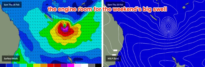
Gotta keep the froth levels at bay. But jeez, it’s hard with such an incredible synoptic chart and forecast maps on hand.
For the short term, we have to be careful to remember that the waves we’re going to see over the next few days will have been generated by TC Winston’s developments late last week and over the weekend. Under these scenarios - where the forecast charts are at the forefront of everyone’s mind - it’s easy to up the ante and forget that swells generated near Fiji take around two or more days to reach the mainland (even more from locations further east).
Right now, TC Winston has actually pushed up inside the swell shadow of New Caledonia. But it’s expected to track south over the coming days, re-enter our swell window and then retrograde westward towards out coast.
But let’s not get ahead of ourselves.
Right now, we’re seeing the surf muscle up across the coast though the wave buoys don’t really reflect the surfcam observations - peak swell periods of just 8 seconds are showing at most buoys. With TC Winston’s weekend travels exhibiting core winds of 60kts+, we should be seeing much more than this (our model has a kick of 13 seconds expected this afternoon, but I wouldn’t be surprised to see a little more than this, around 14-15 seconds).
Nevertheles, this easterly pulse is expected to fill in throughout Tuesday and provide solid waves across all coastlines into Wednesday morning before easing slightly throughout the day and into Thursday morning. Most locations should hover around 4-6ft at the height of the swell (Tuesday afternoon, maybe early Wednesday) and we’ll probably lose a foot or so through Wednesday afternoon and Thursday morning. Expect slightly smaller waves running down the various points.
I wouldn’t be surprised if we saw bigger bombs at some of the more reliable swell magnets up and down the coast (mainly Northern NSW, specifically the Northern Rivers region) however I’m going to cap my expectations at the occasional 6ft+ bomb across these spots. I think TC Winston’s large distance from the mainland over the weekend (while it was east of Fiji) was a little too far to warrant anything much greater than this. Don’t worry though, bigger surf is to come.
As for conditions for the next few days, a strong ridge through the Coral Sea will maintain fresh SE winds across most regions north of Yamba on Tuesday, with light variable winds tending moderate SE south of here. This airstream will ease a little into Wednesday as the ridge relaxes, though SE Qld will still see moderate to fresh SE winds throughout the day.
Periods of early SW winds are likely in the mornings; initially just a few locations (i.e. Coolangatta) on Tuesday, extending to a broader coverage on Wednesday thanks to the weakening ridge. NE sea breezes are expected south of Coffs on Wednesday afternoon.
Thursday morning’s temporary ‘abatement’ - if you can call it that, given it’ll still likely be a little bigger than the climatic surf size average for this time of the year - will be accompanied light variable winds across most regions. An approaching southerly change across the SE corner of the country will strengthen northerly winds across Northern NSW throughout the day, though their influence is not likely to reach much further north than Byron Bay (if it does, it’ll only be light to moderate in strength anyway).
Very late Thursday afternoon is where we’re expecting to see a strong renewal of E’ly groundswell, even E/NE if anything, originating from TC Winston’s southward emergence from the swell shadow of New Caledonia on Tuesday. At this stage I don’t think we’ll see any new swell until mid-late afternoon at the earliest - so expect it’s unlikely that we’ll see much of an upwards trend until the last few hours of the day.
Nevertheless, at this stage its possible that we could see a decent push north of 6ft and possibly into the 8ft range at exposed coasts right on dark , mainly around SE Qld and Far Noerthern NSW. Locations south of here will see the swell arriving a little later so it'll probably push through after dark. I’ll firm up the timing in Wednesday's notes.
In any case, Friday will see this swell showing much more strongly. Most exposed coasts should see strong lines of swell of around 6-8ft at times, and as per the Tues/Wed pulse, reliable swell magnets - mainly in Northern NSW - are likely to push a little higher than this (8ft+, maybe 10ft bombs). Surf size will obviously be smaller down the regional points but based on current data, this particular pulse looks to be the biggest east swell we will have seen in some time. So make sure you're well aware of your own capabilities before paddling out, as it'll be very easy to find yourself in a lot of trouble in a short space of time.
Friday’s winds are currently tricky to pin down with a weak, stalled trough currently expected off the Southern NSW coast that may influence the Mid North Coast, but result in light variable winds elsewhere.
Either way it could be shaping up to be an incredible day of large clean waves in many areas - but let’s give it another couple of days to firm up as I’m certainly not 100% on local conditions. And if TC Winston doesn’t perform as currently modeled over the coming days, then these figures will be up for a revision.
But yeah - it's got the froth levels right up there at the moment.
This weekend (Feb 27th - 28th)
The weekend’s forecast is based on an assumption that TC Winston will recurve to the west during the second half of this week. Whilst the models are in broad agreement about this general pattern, they differ on just how close it’ll come to the coast.
This will influence event wave heights, and also local conditions. A path near the mainland would result in much higher surf, but also fresh to strong S/SE winds; a slower path remaining in the central/northern Tasman Sea would create a little less size but much more manageable winds.
But let’s not kid ourselves - the ‘little less size’ from the second solution is still much bigger than any easterly swell seen in these waters in several years. The first solution could result in a once-in-a-decade kind of swell event.
At this time I’m not sure which way to lead, as there are plausible arguments for both outcomes.
Either way, we are looking at a weekend of very big surf, that will probably overpower just about every major coastline and only provide a handful of rideable options at super protected points breaks. The volume of water moving around will be incredible so it’s really only going to be suitable for very experienced surfers.
To put a size on it, I’m reasonably confident that exposed swell magnets will see occasional 10-12ft sets at some point over the weekend. Surf size will be smaller across broader coasts (i.e. 8-10ft), and protected points will certainly have their work cut out with smaller but still unusually large surf on offer.
Let’s take a close look on Wednesday. But right now, it’s shaping up to be quite a spectacle.
Next week (Mar 1st onwards)
Amazingly, the models have TC Winston - probably a former cyclone by this time - still generating swell for our region through the first half of next week. But we’re out into model fantasy land right now, and there are too many unknown variables that could trend the data one way or the other.
However, it’s unlikely that surf will be in any short supply next week. The only concern is what this endless round of big E’ly swell will do to the sand across the points.
See you Wednesday.
Comments
To borrow an overused phrase...
Yeow !
I think 10-12ft based on the latest gfs is realistic. Still wouldn't be surprised if we saw some bigger bomb sets. All depends on the timing of the recurve.
The DS will be in action.
Is erosion likely to be significant? I think the tidal range should have calmed down by then (full moon today), but still, our coast doesn't get tested by that sort of punch very often.
A 6-8' storm swell in close range with driving onshore winds and a full moon high tide tends to do more damage than a long range, long period swell, as these nearly always break cleanly and significantly further out in the bays. Having said that, if you have say 3 back-to-back swells in the upper range for local conditions, then the 3rd one does a lot more damage, relatively easily and quickly.
At the moment, I've never seen so much sand on the GC points/southern half of the GC, but this once in a decade very strong E swell just might make short work of all that - particularly if the size is 10'+ that might potentially last over 2-3 days.
Agree about the Quicksilver scaffolding - can't see it staying up! If the swell was SE I think it might fare better?
An interesting week coming up!
depends on how close the storm gets. I think longshore scour from close range storms tends to create worse erosion than longer period, longer range groundys. But we'll see.
There's tons of sand every where, so plenty of beach width to play with.
Maybe call a stop work on the Quik Pro scaffold till early March... Can't see that blast wall staying in tact
Caml, put $250 of diesel in the truck ........and have some warm water Desert Storm action at the Ox.
Would love to see Caml get his DS out at the Ox.
The concentration of the crowd into a couple of spots could be equally as epic.
Number of sickies and annual leave now being taken this Friday?
If the surf is 6-8ft though - or bigger - how many surfers would actually paddle out? It's the one gripe with this neck of the woods: such a small number of locations that can actually handle size.
I reckon you'd get a higher number of sickies on a 4ft swell.
exactly.
and alot of sheltered points are going to be 3 foot reform wash throughs.
so it's far from a best case for this part of the world.
But there might be a chance for some clean big waves......if you can paddle out to the bloody things. No deepwater channels like WA/ Hawaii or South Oz. You've got to punch through the bank.
Yeah, you're right Ben, too much for most average punters, myself included. I'm very interested though to see how it plays out on those points that have only reached knee high all summer.
I finish my last shift this Thursday morning, then on some annual leave until Wednesday week after next. To top it off, ages ago the missus and I booked a week staying at Kirra from this Monday and the finance minister (again the missus) has approved expenditure on a new board. Going to buy a lottery ticket me thinks.
As Ben and others noted, will be playing safe and only going when comfortable with size. I'm not as young and fit as I used to be. Still, should be good viewing over the next week or two.
/
Ha Udo. That's exactly what these weeks are for. Isn't it a requirement on an aniversary trip???
Number of old injuries back/knee/shoulder that just so happen to flare up late Thursday
Hi I'm more a photographer than a surfer, so struggle with the terminology a bit. Anyway, where are the "exposed swell magnets" that I keep seeing mentioned in surf forecasts for seq nnsw? D'bah, Kirra? What about in northern NSW? North side of Cabarita is usually really big, but I figure that's a "protected point"? Cheers.
Hi wild
Go to Currumbin Alley and walk out by the large rock there called elephant Rock. If you don't mind a bit of a Climb you can actually climb up on top of the rock and it will be an amazing spot to take photos. There is usually surfers that will be out on jetskis toe surfing these waves.
Have a look at this clip, i'm pretty sure the photographer is on top of that rock I was talking about
Hey Wild, just watch out with the incoming tide or you could get stuck on the rock for 4-5 hours - or more if the swell is building and pulses - it will push right across the rocks.
is that the big rock right next to the surfclub or the rock to the north on the point?
Elephant Rock is the rather large boulder next to the surf club. There is one large rock at the tip of the Alley that is a good vantage point/photo spot.
As mentioned, be sure of all the variables as there will be carnage for the unsuspecting or the foolish. The rocks are fooken sharp too!
I dont ever think i have seen a 10ft wave on the Gold Coast.
This weekend you will, Tweed bar
Theres a late 90s photo of Margo out there ...............15ft plus
Yep, biggest waves I've ever witnessed on the East coast have been out at the Tweed bar. The particular day etched in my memory many years ago was easily 15ft out there. The flow of water thundering out of the Tweed river caused the swell to double up and pitch at least as wide as it was high. From Point Danger, I could only imagine this was a mini- Waimea Bay in Oz. Had to see it to believe it. Never seen it since tho.
Best place that will handle this swell on the weekend is a little island down south where apples grow like weeds. It's gonna be off the dial and is years overdue!!
Am I tripping, or has there been a massive change in course for Wintson and we are now looking at a massive downgrading?? I don't know how many times the report has been amazing, then as soon as you write your forecast Ben the arse falls out. Couple other computer generated sights are showing this.
Yeah tugun, there was quite a change in expected direction in the gfs model with today's run. Stay with freeride's call, based on latest runs it's going to be every bit as big as Guy's call.
The whole summer even with the easterly swell in the 4-5ft range Noosa points at least first point has been lacking size. You look and it's been 1-2ft and hardly looks worth it. Obvoulsy over the next few days with the extra size there should be some bigger waves but I am more interested if this 8-10 ft comes through on Saturday and even Friday. Anyone want to put a size on Noosa if this swell ends up being that big surly 4-5ft at first point. I having only gone to Noosa once so I am interested surly it will be pumping
There are some awesome photos of Noosa when it gets big anyone know how to put photos on swellnet
Fuck off
Chill spider monkey what is up your arse Jesus mate
Seaway?
wow! kinda looks like cyclone watti back in 06 i think, although it was around late march april. North Av was on the pump.... but the water was cold as i remember...... Big lefts all the way to south Av.
Wati is not a close analogue. Wati was fundamentally a Coral Sea cyclone despite being named by Nadi. It tracked parallel to the coast but it was the phase after Extra-tropical transition where it really delivered swell to most of the east coast.
Winston is a South Pacific cyclone. Different animal.
Looking at the model runs and JTWC analysis this morning I'd say a slight downgrade is in order. Mostly due to the expected SE track for a while as it enters the swell window south of the Grand Terre shadow. Thats oblique to the circle path and not optimum for swell production. The recurve is expected a bit later, as it weakens, or after it weakens.
I think the banks will be fine. Still big swell but not massive.
Back when I lived on the GC excitement over this type of scenario was perplexing. It just means 2 things a) there will only be surfable options at very protected locations which, as a result, will be incredibly well populated with surfers and b) the sand will be AWOL for weeks following this.
Totally agree
As an intermediate surfer I totally agree I am craving some 2-3 foot uncrowded gold coast beachies as opposed to surfing the point for 2 hours and catching 4 waves. 4 pretty good waves!! but still....................
Good sets down through Greeny this morning..
Ben regarding the Easterly pulse for Tue to Thu, you cited core wind speeds of 60kts plus. Max winds reached 135kts, after you posted the notes. So basically, did you include those peak winds on Sat in your forecast? And how come NNSW always is forecast to be bigger, except for those coral sea trade swells, just local bathymetry or is it better aligned because New Cal sits in the path to the sunny coast a bit more?
Sorry mate, missed this post.
Core wind speeds from distant weather can't be included into the equation because the radius of these strengths is too small to be of any use. I was referencing wind speeds relative to the windswell-like periods on display at the buoys on Monday (Tp of 8 seconds would get anyone out of bed in the southern states, yet the surf was pumping on the southern GC points).
As for your comment "And how come NNSW always is forecast to be bigger, except for those coral sea trade swells, just local bathymetry or is it better aligned because New Cal sits in the path to the sunny coast a bit more?".
Great question.
There are two aspects to this: first is bathymetry. The continental shelf is a little closer to the mainland across the Far Northern NSW coast, than SE Qld and other parts of Northern NSW (it comes in closer again from about Coffs to Crowdy, but this is often a little less favourably aligned within the swell window for northern weather systems, so there's a slight decay factor here that sometimes balances it out).
The other is more of a socio-impact, in that that most of the surfable locations in SE Qld under solid swell events are at 'sheltered' locations, which means the vast majority of surfers - and therefore their expectations - will be at locations not picking up the bulk swell size. The biggest waves surfed during these kinds of swells are usually across Northern NSW, which means we get a more balanced level of reporting for the size range - even if there are hardly any surfers out, exposed spots in Far Northern NSW are much easier to access and report from.
Sure, it's a broad brush and there will always be excpetions to the rule, but the combination of these two factors is what leads me to often favour Far Northern NSW for slightly bigger sets than surrounding regions.
No worries Ben. I'm with ya now, thought these were Friday's notes for some reason. So you were hindcasting the swell in the water and comparing to your expectations. Monday didn't really muscle up in the water more than what was reflected in the buoy I'd say. I would of thought it just took 3 not 2 days (Sat-Tue) to arrive. Even then, I couldn't really see proper lines in the water til Tues evening. Anyway, different story down there.
Sweet so the swell will be there basically, even if it gets downgraded again to say 6-8max, it'll still be coming into the sunny coast offshore at that max height. It's more just a matter of finding somewhere that can hold our even magnify it.
Thanks again
Hi Ben, just wondering what the size over the weekend will be for the agnes region?
Yeah, i'm interested, too.... Never really got that coast on.... Could be a good alternative for intermediate surfers?
Agnes has been max shoulder to head high and smaller for the last week and a half. I'd be surprised if it got much bigger and being the weekend will be out of control crowded. Wind won't be very co-operative to spread the crowd either. There may be a couple of spots for locals in the know....
Good question, havne't looked at Agnes closely. Usually these kinds of systems are way less beneficial for Agnes because that coast requires flat trades (or cyclones) through the Coral Sea to generate its best swells. We'll probably see a small increase from what you've had over the last week but I am doubtful for any major size - perhaps 3-4ft sets if we're lucky? Will take a closer look later.
fcuking hell, another day of well overhead point surf.....surely no-one can be pining for beachbreak?
freeride, are air t@g or rotorwing still doing flyovers along that section of the coast ?
very quite on the GWS sightings.
Anyone surfing around evans head?
It's not air T N G Udo , they lost the contract. They are only flying weekends at moment to my knowledge and not letting public know if they spot GW's
With all respect, there's a super interesting weather event going on and an awesome swell happening, could you chuck all the 'where can i take a picture? ' 'will there be a shark? ' stuff in a more relevant thread folks? I'm really into the insights provided here and love peoples read on forecasts and local obs. Surfed snapper to greeny today. Sick. A million people, heaps of photographers(maybe set up next to them?)and heaps,i mean HEAPS,of sharks. Wouldn't surf or helicopter near there if i were you!
In said spirit, swell looked to pick up a little after the high tide and had lulls followed by really busy pulses, sometimes like 10 wave sets, really typical of long period swell. The down times in between actually helped by minimising the amount of water movement and wash throughs,i guess by giving it some time to clear down the point.
Winston coming into the swell window............is that another starting to form in pacific sunday/Monday ?
Ben, what is your latest gut feel for winds at dawn on Friday, Sunny coast in particular? A mutual buddy of ours I believe may be there lol.... I've told that person my take in private and where he should look other than that usual place everyone will head to...... There are 2 semi secret spots that handle 8 foot plus open swell....... Different wind angles at both...... So what's your take?
ps - one spot handles 10 foot plus.....
I haven't gotten any emails from Jimmy Biscuit :p
But seriously, didn't even surf today. Even after high as gibbsy mentioned.
If you are referring to the furry rave?
Nah you were the one calling yourself Jimmy Biscuit but still blew your cover haha. Finally seeing some proper lines amongst the onshore onslaught now but. And yeah I'm also sunny coast centric
Hmmmm The purple sweater episode of Seinfeld..... The sands of time have confused you, mitch..... Jimmy biscuit wasn't me.... It wasn't Dave..... He was a fictional character we invented when we were 15yo, mind surfing the tiny perfect peelers we'd watch as we sat on the rocks...... I'm sure we've all done it on those tiny 6 inch days, or even on a river bank watching the wakes from a boat peel along the sand.....
That's jimmy, my friend.... The little guy you picture getting slotted on a 4 inch barrel at yorkeys knob cove.... That chunk of rock at the base of the cove we called "biscuit reef"..... And Jimmy didn't care bahahaha..
Over the years, Dave and I used to greet each other by saying "gday Jimmy"...... Just to keep his spirit alive......
Whenever you see that perfect boat wake peeling along a river shore, the spirit of jimmy lives on bahahahaha.....
Yorkey's Knob. Ha!
I lived there when I was up in Cairns for a year, right next to the golf course. Wouldn't expect anyone to know it.
Dave the rave and I were there in 82/83.... End of high school.. Moved up from the goldy with the family trawler that used to be docked at the spit..... That's where I met Rave.. he moved up from the Forster region.... 2 young grommets on a basically surfless coast going fucking mad.... Used to get a few little wedges in the yorkeys cove next to the rock wall when it was low tide and a 30k se blow used to whip up some shit...... Got our "p's" at 17, and drove up to the ratshit bay area... Got the odd little one there which stopped us from murdering people.... The golf course is where Dave lost his virginty to the beautiful *****, Blue light disco at the community hall..... The 4th hole... par 3 by memory.... Bahahahahahaha
Lol well far out, I swear you tried to pass yourself off as him once on here...
Anyway, since Jimmy's eternally slotted, I'll stop checking my junk mail. Seriously though, I reckon the groundswell only really arrived this evening. Pretty irritating seeing it now at high, and it's peeling wide as. Only 6 hrs earlier and it's was more chopped up and sectioney than an Encyclopaedia Britannica.
Way down south here on the Mid nth coast we still haven't seen any indication of a Cyclonic swell. Winds were nth east t'day and protected crn's were 3ft max! Hopefully a local sleeping giant will turn on just prayin the winds play ball!
Bit smaller than yesterday on the sunnie coast this morning which was a bit of a surprise.
Cleaner though, which was nice.
SC no way 3-5ft gutless rubbish
Swell pulsed nicely yesterday afternoon - some 4-6ft sets across the coast - but seems to be easing very slowly this morning.
Model data still looks reasonably on par with Monday's notes though I'll reassess a little more this afternoon when I prepare the updated forecast. If anything, I think we may see somewhat of a concentration of peak surf heights across the Far Northern NSW coast on Saturday, with wave heights tailing off more than originally suggested (in Monday's notes) across SE Qld and the Mid North Coast.
But let's see what the afternoon update brings.
Smaller here today.
Report said 4-6 ft which is laughable. Yesterday was a chunky 3-5ft today is a rickety 3, maybe 4 ft.
After you said it's gonna be 12 to 15 foot later this week, I dug out the 6,10 swallow and made sure it wasn't dinged by the removalists.. i then spent good money on plane tickets from Adelaide to brisbane... I gotta drive to Adelaide tonight... 5 hour drive..... But I know it's gonna be 12 to 15 foot coz you said so..... So i'm happy.....
This may be a $1m question but what are the chances of Double Island Point firing on the 5th/6th March ? WAMS shows some E swell but looks like a rubbish E winds :(
Gary can't wait to see which chumps those lovable mad hueys have been dropping in on . I just love the look on the faces of the punters who've been paddling for hours as those ripping blokes step off the ski, burn the guy on the wave and then drink a beer in the barrel.
Champagne Comedy.
Ticket booked! Smile at me when my camera is pointed at u.
Have a chat to Ben, Tim..... he knows the deal re' friday morning if the "traditional points" are too big.... Maybe catch up with mick... Get Ben to forward my "stuff" if need be..