Mix of small swells for the region

South East Queensland and Northern New South Wales Surf Forecast by Ben Matson (issued Wednesday 26th November)
Best Days: Fri: SE Qld: small short range SE swell, with gusty SE winds. Lower Mid North Coast: late arrival of S'ly groundswell, with abating winds. Sat: good S'ly swell in Northern NSW, and SE swell in SE Qld, with early light winds in most regions. Sun: Same as Saturday but a little smaller and easing. Mon: new S'ly swell at south facing beaches in Northern NSW.
Recap: Northerly winds ruined surf conditions at most locations on Tuesday, and although a S’ly change nosed into the Lower Mid North Coast during the day, wave heights were smaller than expected. Today has seen light winds across the region and a small peaky combo of swells.
This week (Nov 27-28)
Thursday’s not looking much chop. Surface conditions should be OK thanks to a weak pressure pattern across the region, ahead of a gusty southerly change extending across the Mid North Coast during the morning, reaching the North Coast late in the afternoon and then SE Qld into the evening, which will cause a rapid deterioration.
There’s no major swell expected in the water - a series of small southerly groundswells will glance the region but they’ll only favour exposed south facing beaches in Northern NSW, which will be very bumpy behind the wind change (swell magnets between Coffs and Byron Bay may have some small peaky options early ahead of the change).
A building ridge in the wake of the change will then maintain fresh SE winds across the region on Friday. The associated fetch should whip up a peaky, low quality SE swell for the Far Northern NSW and SE Qld coasts (including some small peelers on the semi-exposed points) but it’s not worth getting too excited about.
Surf size will initially be smaller south of about Coffs, however it’ll be worth keeping an eye on things in the Lower Mid North late in the day, as a decent pulse of south swell is possible from mid-late afternoon (probably just up to about Port Macquarie). There are two sources for this energy - a rapidly eastwards tracking front embedded in the westerly belt through the southern Tasman Sea on Thursday, and another swell with more S/SE in its direction, originating from the stalled parent low well to the SW of New Zealand’s South Island yesterday.
Wave heights should reach 3ft+ at exposed south swell magnets in the hour or two before sunset, and local winds should moderate during the afternoon, allowing for a slight improvement late in the day. However, I’m not confident that we’ll see the new swell reach Coffs Harbour (or anywhere to the north) before close of business.
This weekend (Nov 29-30)
The weekend’s looking reasonable in SE Qld. A stationary ridge across the southern Coral Sea should maintain 2-3ft waves across the Gold Coast, with a few bigger sets possible on the Sunny Coast. However, moderate to fresh SE winds will render the open beaches bumpy with the semi-exposed points likely to be your best option. Keep your expectations low and you'll do OK.
Surf heights will be smaller from this source with increasing southerly latitude, but the good news is that Saturday will also offer a decent south swell at south facing beaches with sets to 3ft+. Winds should be light and variable across the Mid North Coast (ahead of NE sea breezes) but we’re looking at a moderate E/SE flow about the Far North (possibly light and variable for a brief period early). Wave heights will be smaller at beaches not open to the south but there should be enough energy in the water to make it worthwhile.
On Sunday, we’ll see decreasing energy from all sources and early light winds will freshen from the NE in the afternoon. So the morning should again have some small peaky waves at exposed beaches.
Long term (Dec 1st onwards)
Northerly winds are expected to return to the Northern NSW coast on Monday but SE Qld is likely to be spared of any strength at this stage.
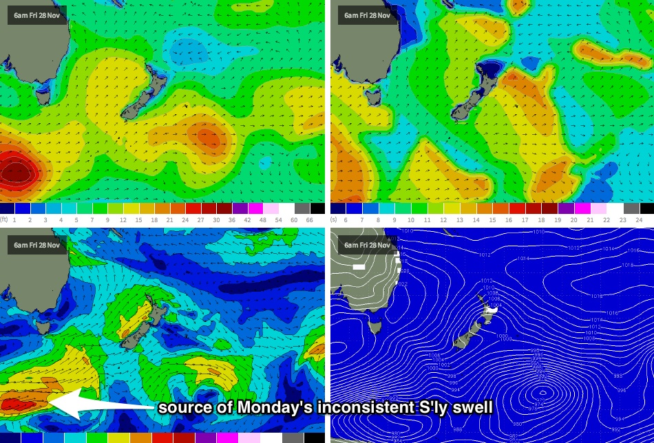
We’ve got a fun new south swell on the cards too (for exposed south facing beaches in Northern NSW, that is), originating from an intense polar low that’s modelled to deepen well south of the continent on Thursday and Friday (see chart below). This system looks unreal on the synoptic charts but it’s expected to develop a very long way from the mainland, so set waves will be very, very inconsistent.
At this stage south swell magnets could see 2-3ft+ waves at times, and these spots should be reasonably clean under the light to moderate northerly breeze. However, I really need to emphasise just how inconsistent this swell will be - you'll need to be extremely patient for the sets. Surf size will then ease slowly from Tuesday.
Unfortunately, a trough in the southern Coral Sea mentioned in Monday’s notes (for this time period) has somewhat evaporated in the latest model runs. However, of much greater interest is the a developing coastal trough across southern NSW early next week, which isn’t showing much on the long range synoptic charts but could very well evolve into a dynamic system capable of producing some sizeable short range mid-week energy across some parts of the NSW coast between Tuesday and Thursday. More on this in Friday’s update with the availability of the latest model guidance.