Continuing small waves for the short term

Southeast Queensland and Northern New South Wales Surf Forecast by Ben Matson (issued Wednesday 4th June)
Best Days: No great days. We'll see an inconsistent E/SE swell over the weekend but fresh southerly winds will create very ordinary conditions at open beaches and there'll be horribly long waits for the bigger waves.
Recap: Small E/SE swells have padded out the last few days with generally early light offshore winds tending onshore throughout the days.
This week (June 5-6)
Small surf is expected to pad out the rest of the week. Residual swell is expected for Thursday and early Friday, with early light winds Thursday gradually freshening from the south as a broad, stationary high in the Bight interacts with a slowly deepening trough across the western Tasman Sea, squeezing the pressure gradient between the two and freshening southerly winds about the East Coast.
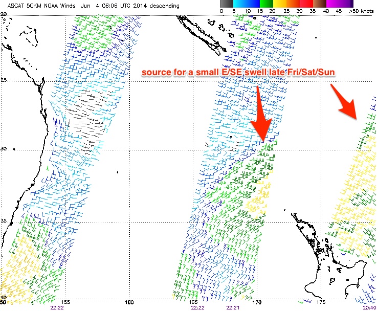
These winds will become quite fresh and gusty through Friday and should whip up a small low quality south swell for exposed south facing beaches in Northern NSW, however of more interest is a small E/SE swell expected to arrive at some point on Friday, originating from a strengthening trade flow north of New Zealand over the last few days.
No major strength was recorded within this fetch (see ASCAT return below) so surf size won’t be very big and it won’t be very consistent either, however by the end of the day we should start to see occasional 2-3ft sets at exposed beaches (it's very hard to be sure just when this swell will reach the coast). However, it's not really worth working around, especially with the freshening southerly breeze that’ll reduce surf quality away from protected locations.
This weekend (June 7-8)
The various computer models on which we base our forecasts went a little skewy this morning, which has thrown a curveball into the long range forecast regarding next week's projected ECL (which I’ve been discussing since last Friday).
However, the most recent data available (18Z GFS) has come back into line, reiterating Monday’s forecast for a strengthening southerly fetch right along there East Coast over the weekend. It looks like Northern NSW (and more so SE Qld) probably won’t see much size from this source until early next week, so the main swell contributor for the weekend will probably be the aforementioned trade flow currently strengthening to the north and north-east of New Zealand.
As mentioned above, wind strengths haven't been especially strong (and are not forecast to be either over the coming days), and there are several other limiting factors for good surf on the East Coast: the head of the fetch will remain quite some distance away from the mainland (a little more than Monday’s estimates), and the latest model guidance has shortened its lifespan too.
Right now we’re looking at the fetch reaching maturity on Saturday which probably translates to a peak in Northern NSW/SE Qld later Tuesday next week. But with the divergent model guidance we really need a few more days to firm things up.
Overall, the weekend’s looking to see extremely inconsistent waves between 2ft and maybe 3ft range at exposed beaches - possibly smaller south of about Coffs due to the orientation of the fetch - and with a good chance for fresh southerly winds you’ll have to tuck into a sheltered location. Let’s review the model data more closely in Friday’s update.
Longer term (June 9 onwards)
As discussed above, the computer models have wigged out a little in the last 12 hours regarding the projected developments of an ECL early next week. Although the most recent GFS run is back on track, the overall confidence levels for this event have been wound back a few notches - and in any case this possible ECL was expected to favour southern NSW anyway.
Right now all of the ingredients are still there for a really significant swell event somewhere along the East Coast during the first half of next week but we’ve simply gotta give the models a few more days to breathe before committing to anything.
Elsewhere, and with the models being quite erratic I don’t want to make a definitive call on the previously-discussed trade swell either, because there’s been too many changes over the last few days. But, as a possible long range source of swell it’s still sitting there somewhere in the mix for the second half of next week too. Let's see how things are looking on Friday.
Comments
Hi Ben, on the weekend forecast:
"Overall, the weekend’s looking to see extremely inconsistent waves between 2ft and maybe 3ft range at exposed beaches"
Is that 2ft(+) of east swell, or a combo of east + south to make that size? Just thinking about size in protected southern corners.
Thanks mate,
Matt
Mainly east swell Matt, however south facing beaches in Northern NSW were expected to see a small level of short range south swell too. I haven't really looked at the charts since yesterday morning so I'll revise all of this in today's notes (should be up mid-arvo). All in all though, don't expect anything epic this weekend.
Has the Ballina reporter changed? Reports don't seem different but the photography is pretty good. I've been looking through all of them lately. Nothing has been particularly amazing, but still good to look at.
Yeah Mitch - our old Ballina reporter Blair recently picked up a new job that had him rostered on to early shifts, so we've got a new guy Levi doing the reports. He's got a good DSLR and has been taking some tasty pics.
Cool. Maybe the wording and tone of the reports has changed a bit. Anyway, we'll see. He doesn't happen to have a social media alias, as a photog/videographer, which you can share with us? I think I kinda recognise the style of photos, so I'm just curious
Thanks Ben!
BTW this messy system we chatted about back on the 2/6 mitch (and don), should still produce surf.... Quite wind affected though for qld....... Two sytems don't look like linking in a decent position( one off FNQ, the other off SNWS) .......And the second upper level system I brought to attention for around the 17thish also looks a goer..... moreso for the southern east coast..... Time will tell.......
The good old sheep shaggin isle looks to do it's usual prick of a trick and disect what would have otherwise been a damn good looking fetch!!!!
Not really, that fetch developing off the North Island looks excellent!!
Would look a whole lot better if fecking NZ was blown up!!!
I don't think it would be nearly as strong. All the strength is on its south-east flank and aimed towards Tassie.
With NZ you're getting a tighter pressure gradient aimed towards NSW and SE Qld, and hence a better swell than if it wasn't there.
Yeah yeah I know what you mean Craig.....but it still kills me when I see that island cut a damn good fetch in half!!! ;)
EC now looking at the same scenario Access G was progging a few days ago with some tropical developments in the Coral Sea towards the end of its long range runs.
Dons original "g" on 2/6 had exact location for trough off FNQ (9th)..... So I gotta give "g" that one, don......
This is an OG call...
?t=2m6sWe owe you one Heuy.