Not quite a great weekend in the north

Southeast Queensland and Northern New South Wales Surf Forecast by Ben Matson (issued Friday 30th May)
Best Days: Sat: early waves at south facing beaches in Northern NSW. Sun: peaky combo of east and south swell with good winds early. Mon 9th June thru' Thurs June 12th: looking good for a decent trade swell. Possibly some ECL action around this time too but more likely in southern NSW.
Recap: Small average surf.
This weekend (May 31 - June 1)
Not a great weekend expected all up, but there will (eventually) be waves to surf.
A small southerly swell is building across the southern NSW coast at the moment, and it’s expected to grace exposed south facing beaches of the Northern NSW coast on Saturday with inconsistent 2-3ft sets (and much smaller surf at beaches not open to the south). Winds are looking a little dicey but should be good early (light and variable), before freshening into the afternoon from the eastern quadrant.
SE Qld won’t see much, if anything from this southerly swell - only exposed south swell magnets will really pick up any energy, and it'll probably be late in the day by which time the onshores will also be up.
This south swell will then ease slowly through Sunday, to be concurrently replaced by a small, long range E’ly swell generated by an unfavourably-aligned low NE of New Zealand earlier this week.
As mentioned on Wednesday, its fetch was primarily aimed up into the Fijian region so the dispersed swell energy we will eventually see at the coast will be much smaller than what we have seen from similarly placed (but more favourably aligned) systems over the last few months.
The Sunny Coast will pick up the biggest waved from this source (inconsistent 2ft+ sets) and it’ll become progressively smaller as you track south to the Gold Coast and Northern NSW coasts. Hopefully there’ll be enough residual south swell in the mix to provide some peaky waves at open beaches, however mainly onshore winds (possibly variable early) will keep conditions below average for much of the day. Keep your expectations in the low to moderate range.
Next week (June 2-6)
There’s nothing much in store for next week. A developing trough along the southern NSW coast this weekend will be located outside of our swell windows, however a high to the east of this trough will direct a moderate ridge across the northern Tasman Sea that’ll provide some small peaky E/SE swell through Monday and Tuesday (say, 2ft exposed beaches).
The trough off the southern NSW coast will remain slow moving for a few days, and although there’s a chance for a small return south swell off its western flank later next week (Thurs/Fri) we probably won’t see much more than 2-3ft at exposed south swell magnets in Northern NSW. And very little in SE Qld apart from some residual trade swell.
Longer term (June 7 onwards)
Some models are pointing to a deepening trough in the central/western Tasman Sea late next week and into the weekend that could very well spawn a significant swell generator for parts of the East Coast either next weekend or early in the following week (possibly an ECL too). However current model guidance is more in favour of the southern NSW region than the northern - let’s wait and see how Monday’s model runs evolve this scenario.
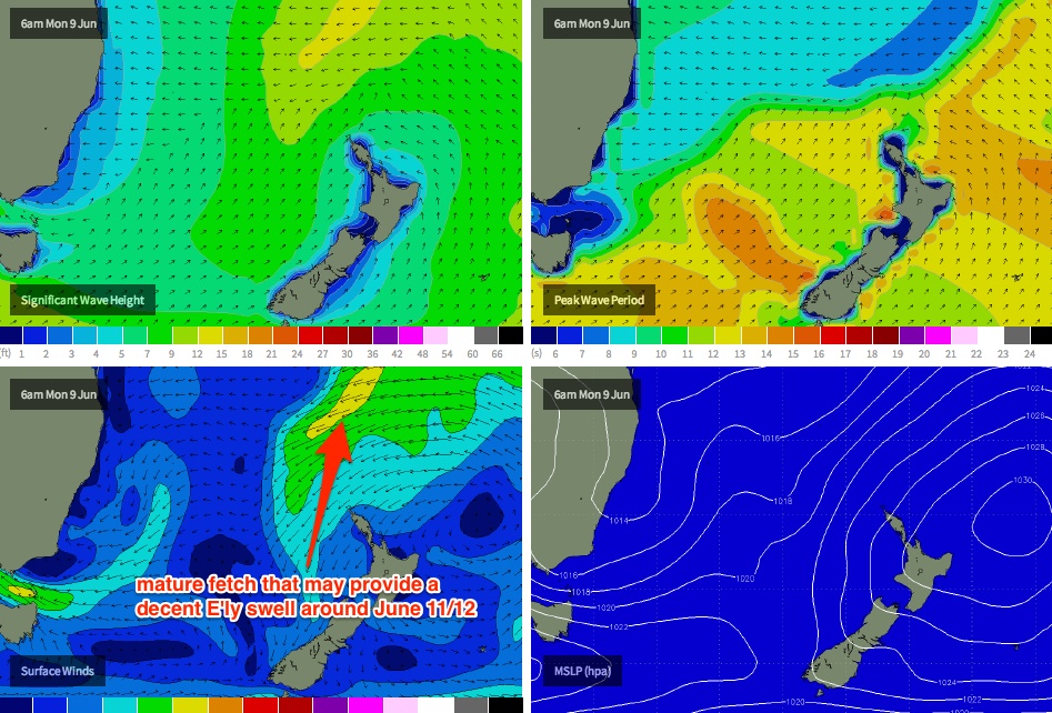
Elsewhere, we also need to keep an eye on the area north and north-east of New Zealand that’s been a regular spanning ground for long range east swells over the last few months. There’s nothing of major significance on the charts right now however there is a suggestion we’ll see a slow moving, strengthening high in this region through the second half of next week, through the following weekend and the early part of the adjoining week that could provide some mid-range trade swell (arriving sometime around Monday 9th, reaching a peak around Wednesday 11th or Thursday 12th). More on this in Monday’s update.
Comments
I'd look at a possible upgrade for "June 7 onwards"...... An umpteeth low may form, or a very strong trough wedged north the high at least, creating a fetch of "above trade swell" proportions.... Things should be clearer tomorrow....
whoops.
Getting some flat top highs now :)
Monday, 9th june, 0600....... What a peculiar map....... A precursor? 9th thru 16th could be quite interesting....
Which model, time run SD? GFS 18z run?
Don - http://www.metvuw.com/forecast/forecast.php?type=rain®ion=swp&noofdays=7
Also have a look at your bellmere site.... Plus check 16th/17th whilst there too....
That's 18z GFS run SD. I'd much prefer the EC latest prog.
http://old.ecmwf.int/products/forecasts/d/charts/medium/deterministic/ms...
And 16th/17th.....that's a fortnight away mate. I know you work for NOAA but for us mere mortals that don't have access to the inside manipulations of the computer models, 14 day weather charts should just be laughed at.
"14 day weather charts should just be laughed at." I'd agree...... 90% of the time...... But when the 7 day chart spells out certain precursors.... Well........ You'll notice patterns one day, champ ;)
Ok, I'll watch and learn, champ.
hehehe........ Moisture...... It's all about moisture..... ;)
Well whilst we're talking moisture how's this chart for early June!!!
http://www.weatherzone.com.au/models/?lt=wzcountry&lc=aus&mt=accessg&mc=...
Don, looks impressive.... Bottomline, somethings on the brew.... Seen warm starts to winter like this before -all 4 maps show heaps of warm moist easterlies.... Big "dead" area between 2 highs off east coast..... Upper level moisture moving in from west on 2 predicted occasions (9th - 11th, 15th -17th) - even that benign ecmwf map you supplied showed inland rain over NSW with no surface system - obviously an upper level trough....... All 4 maps metvuw, bellmere, ecmwf, accessg show strong indications to possible ecl..... one scenario for 11/6 coinciding with upper system, second scenario for 16th/17th with next upper system....... Just a matter of which of the two upper systems, and what part of coast between Townsville and Eden.... Time will make things more clear on that one.....
These potential ecl sytems often hail the true start to winter ( after a warm june intro') , close to the solstice... They "flush" autumn patterns out.....
In this case Doggie, I think the ECMWF colour means wind speed in m/s. Not to knock your whole argument down though.
It still looks like a troughy high with that L just sth of New Cal, so moisture feeding across to Aus no doubt
And a massive warm pool(?) above, by the 500hPa (height? in ? units). More signs of moisture feeding in and potentially spinning up
And I'd say the Mbah bouy is registering some energy from the east, which was mentioned above.
Actually SE according to Byron and Brisbane buoys.
So if the "small, long range E’ly swell generated by an unfavourably-aligned low NE of New Zealand earlier this week." is actually arriving here from the SE... why?
Singular buoy data has to be taken with a grain of salt - unfortunately it's not always representative of what's in the water. And it also depends on the buoy manaufaturer, as they all do things slightly differently than the others. For example, the NSW buoys (all Datawell) struggle to display the correct directional data if there are two swells in the water with a similar period - it'll split the difference (so if there's a NE swell and a SE swell with a similar period, it'll display the singular direction value as E'ly).
The spectral data should be a more accurate representation of the various directions however I have observed many anomalies over the last year or so (ever since the spectral data was released) that seem out of whack with what I have observed at the beach. Not sure for the reasoning behind this - maybe my own interpretation is incorrectly biased - but ever since the new displays were live on the MHL website, something hasn't felt quite right.
BTW, averaging the singular direction data at Byron and Tweed Heads over the last 12 hours shows that it's been E/SE. Brisbane is SE though, not sure for the reason behind that (although the Brisbane buoy's direction is frequently a little skewed against beach obs IMO).
The great circle paths are not that close, I've tooled around in google earth trying to see if it was possible to confuse swell directions, and the apparent changes are too insignificant
Looks e - ese to me.....
Ok my bad. I thought you were referring to the other lower period swell. It's E/SE for the swell you're talking about. Around 115-120 deg or thereabouts.
It was ESE. Just bigger than called.
I was in the water at Tallows beachie early yesterday arvo FR, and I'd say the sets were lining up from somewhere sth of straight in, so SSE. Didn't count the period unfortunately cos I was paddling around though. Did see small lines coming from N of E, but don't think it was backwash from the headland. The Bay didn't have nothing.
If you drew lines of best fit across the period graphs (mean and peak), by eye, I'd say you could match that to directional change towards the E (keeping in mind your note about mixing swell directions of similar period ben), from today. Perhaps the mbah buoy peaking with 13sec energy yesterday was all Sth energy making it's way in and dominating all other tiny residual swell? Today is 'the east swell'?
So FR, "it" was today? I ask cos I'm wondering if the little ENEish lines I saw were a proper swell to factor into next time when hunting for some bowlyness on less crowded stretches
And DW your initial comment about SE was implying that the Brisbane and Byron buoys can be taken with a lesser amount of salt than others, right?
MV, I just always rely more so on Brisbane and Byron (partic byron with it's multi-spectral display) if I want to see what swell periods and directions they are. Tweed, Goldy and Mbah all get contaminated (directionwise) when there's longer period swells due to their location and/or shallower water.
Mitch, yeah my bad re' that one map... But doesn't knock prediction down at all, if not reinforces it...... That looks like the most dodgy of the 4 maps anyway imo.... Weatherwise, something is definitely on the brew for the east coast re' that time frame... Eyes wide open... And lets hope it correlates with maximum swell potential...