Incoming from the east, then strong from the south

Southeast Queensland and Northern New South Wales Surf Forecast by Ben Matson (issued Wednesday 21st May)
Best Days: Thurs/Fri/Sat/Sun: Fun, long range E'ly swell for the open beaches. Good surf just about everywhere. Sat/Sun/Mon/Tues: pulsey, slowly building series of south swells that should offer some strong sets late Mon and Tues (at exposed south swell magnets).
Recap: Slowly easing trade swell with good winds.
This week (May 22-23)
Looking good for the rest of the week. A new east swell is expected to slowly build across the coast during Thursday, generated by a tidy low pressure system located mid-way between New Zealand and Samoa over the last few days.
The timing on this swell is hard to pin down for a couple of reasons - firstly, the swell source is a very long distance from the coast, so any small errors created in the initial assessment of the fetch will magnify greatly over time.
Secondly and similarly, our model didn’t resolve the fetch very well (resulting in slightly smaller swell periods that what'll probably develop), so consequently surf size is down on what I think will happen at the coast (and what the swell graphs are showing).
And thirdly, because the region’s network of wave buoys extends no more than 20kms off the mainland, there is no advance warning of an incoming east swell - by the time the buoy data is received, processed and uploaded to the internet, the swell is (in most cases) already visible on the surf cams. This is in contrast to south swells, which we can track up along the southern NSW coast to refine its ETA in Northern NSW and SE Qld.
The good news is that this system had a broad fetch that remained (and still remains) reasonably slow moving at the height of its swell production. So although inconsistent, the swell quality should be quite good. We’re looking at set waves building on Thursday into the 3ft range by the afternoon across SE Qld and the Far North Coast, with smaller surf south of about Yamba or thereabouts.
Winds should be mainly light and variable with sea breezes, so conditions should be quite good (although the afternoon session may gets little bumpy). Keep in mind that due to the uncertainty on the swell’s timing, it may be undersized in the early morning. And it'll be inconsistent at times too.
Friday should ramp up a little more with inconsistent sets in the 4ft range across the north, and a little smaller in the south. Again, we’ll see similar winds - mainly light and variable with sea breezes. Friday will also have a small south swell in the water across exposed south facing beaches in Northern NSW, but it’ll be much smaller than the dominant E’ly swell.
This weekend (May 24-25)
Friday’s east swell is expected to hold into Saturday morning before easing slowly into the afternoon and further into Sunday. Size wise, we’re looking at inconsistent 4ft sets early Saturday in the north, tapering off to about 3ft by the afternoon, easing to 2-3ft on Sunday. But keep in mind that there will be long breaks between the bigger waves.
At this stage winds are looking very good, due to there being no synoptic driver along the coastal margin, so early light offshores and afternoon sea breezes is the most likely scenario.
Exposed south facing beaches in Northern NSW will also pick up an intermittent south swell over the weekend, no great size but worthy of occasional 2-3ft sets that’ll probably peak on Sunday. However it’s not an especially reliable source so I’d focus your attention towards the Fri/Sat east swell.
Long term (May 26 onwards)
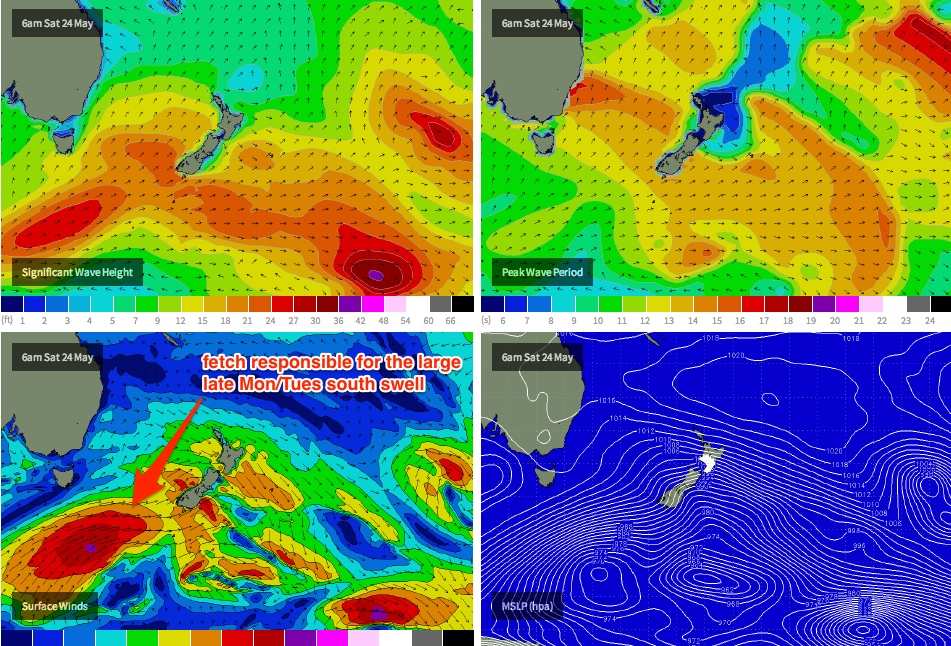
The easterly swell tap will be turned off for next week, but the good news is that the southerly tap will turn back on. A long conveyer belt of weather systems traversing the Southern Ocean south of Tasmania at the moment are generating an initially unfavourably-aligned swell that’ll slowly swing in favour of the East Coast through the weekend (as mentioned above).
However, the final frontal push in this series is expected to be quite a significant system. It’s modeled to track through the central / southern Tasman Sea over the weekend (see below), generating a large S/SE swell that’ll make landfall across the lower Mid North Coast on Monday, reaching the Far North Coast and SE Qld late in the day or (more likely) overnight.
Right now it’s hard to be sure when we’ll see the biggest waves from this source - late Monday is a possibility in the south but Tuesday looks like a safer bet in the Far North (and Tuesday will also maintain strong, sizeable waves in the south). However, very little penetration is expected north of the border - so if you’re in Qld and aiming for a surf early next week I’d consider a road trip south of the border. I'll pin down the timing a little closer in Friday's notes, mainly with regards to Monday's size prospects.
Size wise, the peak of the swell should deliver 5-6ft surf at south facing beaches, with smaller 3-4ft waves at remaining open beaches and tiny surf inside sheltered southern corners. Ordinarily it’d be expected that the accompanying long period would do good things across the exposed points; however it’s likely that we’ll see a northerly flow to develop as the swell is reaching a peak - mainly along the Mid North Coast but possibly extending north to about Ballina (SE Qld should be largely spared from this synoptic wind, although the afternoon sea breeze will probably be moderate to fresh NE, and surf size will be tiny away from the exposed beaches). More on this in Friday’s update.
Comments
If this is anything to check by...
Auckland East report 2-3ft+
http://gosurf.co.nz/location/auckland-east#.U31SPnKSymU
Bay of Plenty buoy Hsig, Hmax & Tpeak of about 1.25m, 2.2m & 12.4sec
http://monitoring.boprc.govt.nz/MonitoredSites/cgi-bin/hydwebserver.cgi/...
Mt. Maunganui report 2-3ft+
Swellnet WAMs Whakatane forecast 3ft surf. 1.6m @ 11.8sec
p.s. why the difference in modelled surf size? Swell is very similar. Great Barrier Island vs Whakatane...
Alignment of the coast.
Between the point where the swell is modelled, and the stretch of coastline for which the surf forecast is generated?
i.e. swell is forecast to come into the BOP.
Surf is forecast to hit a stretch of shoreline.
Obviously it's calculated at the virtual buoy point, but we've estimated the average coastal alignment for each virtual buoy (say, a 20-30km stretch) across our global network. In general this works well at most locations, but there are some areas that have much more complex geography, so we have to compensate in other ways (for example, placing two virtual buoy points on either side of a broad peninsula, each facing towards a different primary swell source).
a)
coastline /
/
/
/\
|
Swell 1m. Surf 1ft.
b)
coastline_______________
/\
|
Swell 1m. Surf 2ft.
If SF, NF, etc tweak (in orange colour on bar graph forecast) were applied to this example and the GBI v W example, both surf forecasts could potentially have 4ft surf then couldn't they.
Well, each location has a "full potential surf height" that we don't display, so yeah that's probably correct. However there are a number of other parameters that also contribute to the overall surf height calculation, which I can't really discuss as they're commercially sensitive.
Another example, rather than applying the SF, NF, etc tweaks to Kangaroo Island, you've totally separated them into different forecast regions. And if I was really sporty if I was down that way, I'd look at KISC and KIWC to get an idea of WF options on the KISC
SF and NF calculations are exclusive to East Coasts, because of the wider range of possible swell sources. This doesn't really occur in the Southern Ocean (ie you don't get a W'ly swell in SA, followed by an E/SE swell) so these locations have this functionality omitted.
Okay cheers, think I just got used to seeing the SF/NF calcs and stopped thinking about it as a default position. I don't know NZ east coast well enough either, assumed GBI & Whats had pretty much the same alignment and exposure
Okay cheers, think I just got used to seeing the SF/NF calcs and stopped thinking about it as a default position. I don't know NZ east coast well enough either, assumed GBI & Whats had pretty much the same alignment and exposure
Spot on forecast.
A 3/10 or a 4/10 Freeride...?
Just looked at your moffats cam.... 1st signs trickling in.....
Unfortunately no signs of a proper groundswell. No proper drainers on the groyne late this arv
heheheheheeeee!
Good action today but, much straighter and not too many double ups between different swell trains. Went some sandy options too though
Classic Burleigh Cam, not many people out 7.57am 24.5.14 haha.
Huh?I saw a screeny, cooking but crew on it
Shit loads MVG, a joke
Mate.... Sat morning.... Swell aplenty..... Rather mow a lawn that go to burleigh.... One of them days when sunny coast will outshine the goldy.... Heaps of options, if you know where to look......
If I was on the goldy at dawn this morning,,,, a paddle across to somewhere, the neck, maaaaaaybe south of burleigh but north of currumbin (banks near walls pending), or drive south.....
Donweather; In hindsight - Swell arrived late thurs/ early friday.... Peaked 3 -4 foot..... started at 11sec, increased with pulses in the 13 - 14 second region. ;)
Haha I was taking this morning too seriously, as Caba had been suggested and I wasn't keen on a big fat burger for breakky. Luckily, we just went straight to the beachie
SD swell peaked this morning mate. Without a doubt both in period and swell heights. Was a solid 4-5ft where I was this morning at dawn but waned back to 3-4ft close to lunch time. And he's SD I'm at a very northern SC location so I got the better of the swell by the looks of it.
Yeah dropping fast now went for a late at Sunshine, by 1600 its only 2/3 ft. but still nice. Great day to be a surfer tho.
Nice, Donny.... And I suppose you'll be back near the border in time for that southswell.... It's a tough life but someones gotta do it :)
The Don of weather
Geez 15ft forecast for Monday at Raglan, when it gets that big sometimes it links up all the way from outsides to Manu bay....?