Fun east swell arriving later this week

Southeast Queensland and Northern New South Wales Surf Forecast by Ben Matson (issued Monday 19th May)
Best Days: Tues/Wed: fun, easing trade swell in SE Qld. Keep an eye out at exposed souths well magnets in Northern NSW for a small, inconsistent long range southerly swell. Late Thurs/Fri/Sat/Sun: Fun, long range E'ly swell for the open beaches. Good surf just about everywhere. Fri/Sat/Sun/Mon/Tues: pulsey, slowly building series of south swells that should offer some strong sets late Sun and again early in the following week (at exposed south swell magnets).
Recap: Punchy but wind affected trade swell over the weekend, biggest in SE Qld and smaller south of the border where winds were lighter. Easing tradeswell today with greatly improved conditions as winds become light across all regions.
This week (May 20-23)
We’ve got a fairly linear surf forecast ahead for the next few days. Essentially, the trade swell that peaked over the weekend is expected to slowly ease from Tuesday through Wednesday and into Thursday morning. SE Qld will see the most size (with very small surf from this source south of about Yamba), and winds should be favourable each morning in the north under the influence of a slow moving ridge of high pressure.
Winds are expected to veer southerly across the Mid North Coast during Wednesday morning as a weak change clips the coast, but it’ll weaken quickly into the afternoon and tend light and variable again for Thursday.
A small succession of south swells are moving up the NSW coast and may provide very infrequent waves to super exposed south swell magnets in Northern NSW on Tuesday. As of this afternoon, 3ft sets had been observed via the Newcastle surfcam (a reliable south swell magnet) but there are very long breaks between waves so I wouldn’t hold your breath for anything noteworthy.
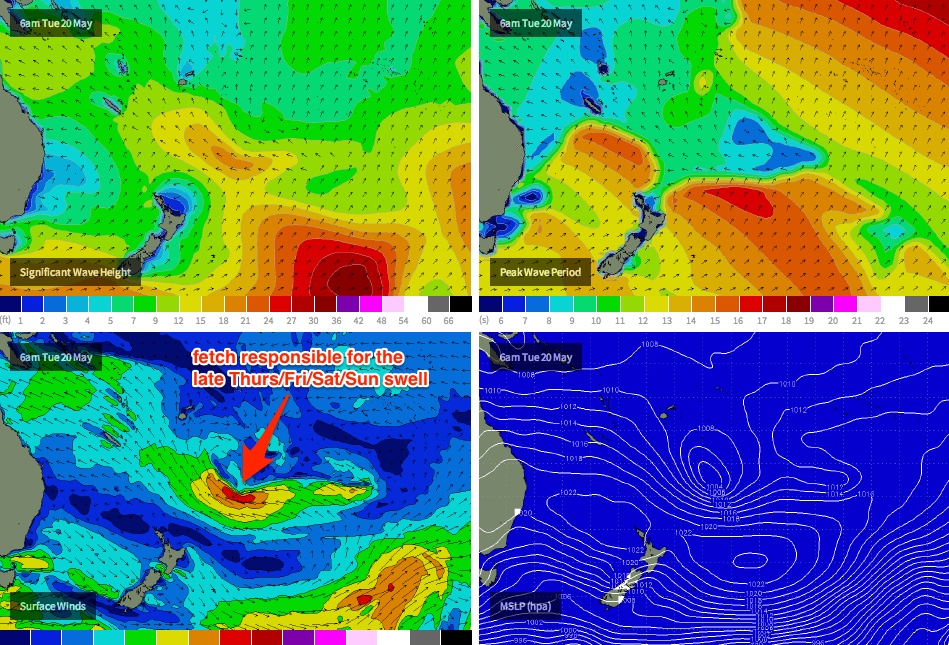
Thursday afternoon will herald the arrival of a mid-period, long range trade swell generated by a healthy E/SE flow that developed between a deepening trough and a broad high pressure ridge NE of New Zealand on Sunday. The fetch is expected to reach full maturity in the next 24 hours (see below), and although a long way from the mainland, this source is expected to provide some good waves across the region, peaking later Friday and into Saturday. At this stage I think our swell model is slightly under calling wave heights from this source, and we’re likely to see inconsistent 4ft sets at exposed beaches between the Sunny Coast and about Yamba at the height of the event, with smaller surf to the south.
Winds are looking good for the end of the week at this stage so I’d recommend penciling in some beach time on Friday. But let me stress the inconsistency one more time: there will be very long breaks between the sets.
Late Thursday and (more likely) Friday will also see the first stage of a building southerly swell across the Northern NSW Coast that’s expected to provide some great waves later in the the weekend. Right now, the early stages of the storm track alignment isn’t great for the East Coast but we should start to see some infrequent sets into the 2-3ft range reaching exposed swell magnets to finish off the working week. However, the east swell will certainly be your main focus during this time.
This weekend (May 24-25)
The weekend’s looking really good just about everywhere. Friday’s east swell is expected to peak on Saturday, before easing steadily through Sunday and despite the long wait between sets there’ll be good waves about most beaches. Again, expect long breaks between waves from this source.
Of more interest (at least for Northern NSW) is a series of much stronger, more ‘meridionally’ aligned (north-south) fronts through the lower Tasman Sea later this week and into the weekend. This is expected to generate three or maybe even four days of pulsing south swell across the East Coast that will probably build across the Northern NSW coast from Saturday afternoon ahead of an initial peak later Sunday. Exposed south facing beaches are likely to see set waves up to 3-5ft from this source, although the swell direction will restrict size elsewhere. I'm not expecting much, if any size from this source to make its way north of the border, bar a couple of the regional super south swell magnets. I’ll update the specifics in more detail on Wednesday.
Long term (May 26 onwards)
A series of secondary fronts in the progression described above are looking good for a renewal of long period south swell through the first part of next week, potentially peaking in a similar size range across Northern NSW as we’re expecting to see over the weekend - but with very small options in SE Qld at best. More on this in Wednesday’s update.
Comments
Ben how come your model is under along this one?
Also I note that your model for Thursday is also delaying the arrival time of this swell compared to other WW3 sites?
Hi Ben, I know it's early but any idea of local winds on GC/NNSW for the weekend?
Thank you!
Not sure Don, I reckon both the heights and periods are under a little. The travel distance is quite a long way and there was no preexisting sea state - I'm not overly surprised to be honest.
However it's worth nothing that I've just checked the model output for MSW and they're (1) barely showing any trend all week in SE Qld (4-6ft today, 3-5ft Tues, 3-4ft Wed then 3-5ft Thurs/Fri), and (2) forecasting a peak of 3-5ft (face height) for the Sunny Coast on Friday. That's a little smaller than our forecast.
Mk1, looks like mainly offshores (WSW) Sat with an afternoon S'ly change that'll probably domainate most of Sunday with moderate to maybe fresh SSE winds. Should see early SW winds Sunday morning in a few selected areas though. Let's see how the models evolve over the coming days.
Doggie, in order for a "shadow" to bomb, does it always have to be 'supported' by instability, in the form of a front , to the sth?
Thanks Ben.
No, Mitch.... Well that's an opinion... Most lows that bomb south of Newcastle are associated with a front. But winter bombs off Qld can form without frontal interaction. The most important factors i feel re' Qld bombs are upper level instability moving in from the west, an inland trough, and a good feed of moist e/ene winds from the pacific thanks to an oddly positioned high..... The tip of a cold front sure helps, but is not essential.
I remember one bomb... late july 2001 I think.....maybe 2002................................ Just checked BOM archives - late july 2001. Another in 2003, june 24 which actually bombed s/e of townsville thanks to an inland trough that moved east and mixed with a moist easterly airflow.... No cold front needed at all....
Latest ASCAT is showing some 35-40knt winds in that fetch. Perhaps she may come in above expectations....although I haven't looked at the forecast winds to see if they were also progging 35-40knt winds?
You can see the forecast winds in the image above are 35-40kts (red band) which are expected to reach peak strength this morning. So that appears to be very close.
Thanks Ben, Unfortunately your image above was truncated for the wind scale numbers so I couldn't compare.
Above you said you thought the WAMs are a bit under. Now that wind strengths appear to be very close, do you still think the WAMs are a bit under? I know you're busy and the fetch is still active, so we'll find out tomorrow arvo. I guess it could be down to various other factors, duration of fetch, etc...
Been alot of action out in "elnino alley" this year... As stated many times, east coast north NZ must be having a golden season..... Whanga bar..... Looks like more possible action next week.
I would've thought so too, but this guy says otherwise>...
http://gosurf.co.nz/east-coast-swell-alert-small-wind-ground-swell-event...
Looking at the 4th to 6th of may mslp, I find that astounding..... Suppose it is 2 weeks ago.....
I have to go home that week 2nd June.....whats your thoughts NE NZ Sheepio??
Mick free, just looking at the long term charts, and for what it is worth, unfortunately, it doesn't look all time.... There seems to be some form of tropical disturbance out around 170/30s, 29/5 onwards..... Keep your eyes on that one.... probably your best chance for east coast action...... Long way off though..... Interesting system for west coast 150e/55s 28/5... But that ship may have sailed by the time you get there.
Have a play around with this site, Mick. On the bottom tool bar, click on the date and adjust animation duration accordingly... map can also be scrolled to suit position....
http://www.wunderground.com/wundermap/?zoom=4&rad=0&wxsn=0&svr=0&cams=0&...
ps nice tassy pics bro ;)
Sheepio quick q, are the colours inches of rain/3hrs?
Ha! June 2003 and TC Gina, then that low. The SOI was strongly -ve but don't know about SSTs. Crazy. Would be nice to see if the jetstream gave any clues a few days in advance too.
And June 2004 had a couple a lows drop down cyclone alley.
2001 July 22nd -26th or so must've puuuuumped in Fiji. That ECL on the 28th was much easier to see coming than the one mentioned above, inland instability for quite some time preceding it. 2001 was slightly -ve SOI.
One thing I find interesting is the comparison to N America east coast. Those lows seem to always track polewards and eastwards. It seems as though
- when the low comes off land, it goes poleward
- When the low spins up off a front on the ocean (Aust), it goes equatorward. OR
-------------ECLs go poleward
-------------Tasman Lows go equatorward?
Anyone keep an eye on other east coasts? Like the NW Pac storm track?
Ballina report continues to be a delight.
On a much smaller, weaker day today we get a six out of ten. The day of the year got a seven.
It's weak as piss today.
Meanwhile this day with OH barrels got a four.
The reporter needs to moderate his drug intake before posting.
just as comparison, this day was given a five.
Freeride , his reports aren't going to clear the moderate range till he sees Goodvibes shoot full bore through the backdoor into a head on with a garlic prawn.
I know but now he's giving tiny days higher scores.
Classic over compensation. He's rattled.
Well I wonder who rattled him!!!!
A seasonally average day should be given a five. Thats easy logic.
Less than average four or three.
Crap two or one.
Better than average follow the logic.
Today is slightly less than average. Should be a four.
Why do you care so much about the ratings? If there's waves and you score with the rating being low will it make any difference to your surf if the rating was higher? Just be thankful that you can get a surf whatever the rating and maybe a few less in the water accordingly.
you're totally right Seal.
it's a character flaw.
Hmmm, the peak of this swell may now actually arrive under the cover of darkness.
bit of a choclate starfish on the ASCAT passes now. I agree don, Tuesday night/wed morn +3 days travel...
More ripping ASCAT passes
Yep, saw those this morning.....but still only really in line with the forecasts so no real change IMO.
Bummer. Which forecast? Is ACCESS/AUSWAVE over cooking it with 2m @ 13sec clipping the northern tip of Fraser on Fri morn?
I'd reckon so with 2m@13 sec!!! That would equate to 6ft sets!!!
Where do you get this info from for AUSWAVE?
Edit: Just found this page: http://www.bom.gov.au/nwp/doc/auswave/data.shtml
So the BOM use WW3 but not GFS wind fields....Access wind fields....interesting. But where can I actually find the latest AUSWAVE plots/data sets? Anyone provide a link please?
EDIT EDIT: All good, found the charts. Very different to GFS/WW3 plots with respect to swell periods and dates/times!!!
Yeah DW I just eyeball the plot, use the drop down menus to get what you like
http://www.bom.gov.au/australia/charts/viewer/index.shtml
Not sure if you can get the data in spreadsheet form...?
I think you need to be a registered user to get the data in data file format. It would be extrenely useful to get this data in a spreadsheet format for sure!!!!
If anyone wants to help me fund the $3,300 per year to get access to the raw data, please let me know!!!
http://www.bom.gov.au/other/charges.shtml
Very interesting information contained in here regarding the accuracy of forecast swell periods from the AUSWAVE model compared to the GFS/WW3 model (I presume this is what they refer to as the US model?).
http://www.bom.gov.au/australia/charts/bulletins/apob97.pdf
Indicates that the US model tends to underpredict swell periods.....one would also then assume that the US model tends to underpredict swell arrival times then too, wouldn't it (ie lower swell period, means slower wave speed, hence later arrival times)?
Bit of a gold mine this is... fairly advanced stuff though, pretty heavy on the stats!
You love the heavy stats Mich Very Good,
Does Ben SN have a registration......?
it's true :O
The plots often struggle to display a very clear swell train moving through the water. E.g. this east swell, coming with a peak period under that of sth swell. Sometimes I interpolate backwards, from when the train is clearly displayed travelling WNW through the Coral Sea...
Those bulletins are riveting reading, seriously! Blowin, they even list all the acronyms used!
Edit: hahaha yes DW have been reading them also. I began to comment, then spent about 15min trawling them. Came back to complete this comment, then found your words after I'd posted haha.
And yes finally to respond to your surf size comment, it does mean something like 6ft surf! As a general rule of thumb: If ya stock standard south swell (using the primary swell plot; mid period) sweeps by the NNSW coast in dark blue, the magnets will be well overhead.
We will never knoe Mitch Very Good.
The synoptic WAMS on SN yesterday and right know looks great IMO.
Lets wait and see eh, interesting stuff for this time of year. Would love to see the outcome of swell on the east coast North Island...?
Yeah Welly, I had some mates go over to the coro at easter. Surfwise, ya wouldn't travel so far for it but tourism wise, gorgeous!
I swear the system has tightened up compared to forecasts several days ago!
Welly, best best kiwi buddy "spart" is from the mount... Lived at whanga most of his youth...Raves about the left..... Seen personal photos...... Man.... tasty at 5 foot....
Whanga Bar cranks Sheepio also the rights down the beach, have you surfed there...?
When the East coast of the North Island cranks, there are so many hidden gems along that whole stretch of coastline that absolutely open up in all their own little fame, probably similar to where you live now ;)
Those swells also head around towards Gissy and Mahia and south :), many an option.