Fun weekend down South, tons of swell next week
South Australian Forecast by Craig Brokensha (issued Friday August 1st)
Best Days: South Coast all weekend, South Coast Tuesday, both coasts Wednesday (South Coast morning), both coasts Thursday and Friday (mornings South Coast)
Features of the Forecast (tl;dr)
- Reinforcing, moderate sized SW groundswell tomorrow AM, easing into the PM and Sun
- Local offshore winds tomorrow ahead of sea breezes, freshening N/NE tending N/NW Sun
- Small Mon with strengthening N-N/NW winds and a building windswell on the Mid Coast
- Large W/SW groundswell for Tue, peaking in the PM under fresh W/NW winds
- Easing swell Wed with variable tending SE winds
- Large W/SW-SW groundswell Thu, easing Fri with E/NE-NE tending SE winds
Recap
A tiny W/SW swell provided 1-1.5ft waves across the Mid Coast yesterday, similar today though less consistent. The South Coast was weak and lumpy yesterday while our new SW groundswell is coming in strongly today with 4ft sets off Middleton with a better offshore wind. Conditions are still a bit lumpy but good for a surf.

Solid sets this morning
This weekend and next week (Aug 2 - 8)
Today’s initial pulse of long-range SW groundswell should be backed up by a similar sized pulse of reinforcing energy late today, with both due to ease back through tomorrow.
Local winds look good and locally offshore tomorrow morning ahead of weak sea breezes with 3ft to occasionally 4ft sets due off Middleton, easing through the day. The Mid Coast looks to come in at 1ft.
The swell looks ease back from 2ft to possibly 3ft across Middleton on Sunday as moderate N/NE tending fresher N winds create great conditions all day
A low point in swell is due Monday morning, through strengthening N-N/NW winds will kick up a building windswell across the Mid Coast as a strong mid-latitude low approaches from the west.

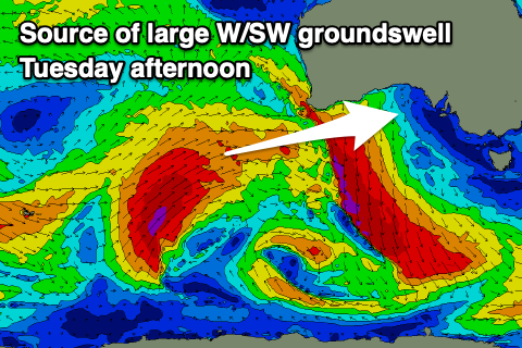
The earlier stages of this mid-latitude front will be a very strong polar low, forming around the Heard Island region last night. A fetch of storm-force W/SW winds will project slowly towards Western Australia, then through the Bight, with a mix of large W/SW groundswell and mid-period energy due to fill in Tuesday, reaching 3ft on the Mid Coast with Middleton building to 3-5ft into the afternoon.
Local winds look fresh out of the W/NW for most of the day, favouring the South Coast over the Mid Coast, with more variable winds due on Wednesday as a trough moves across us.
The swell looks to be easing ahead of our secondary pulse of large SW groundswell Thursday.

This swell looks to offer more size and consistency across the South Coast, generated by a more robust but weaker polar frontal progression pushing towards us from the Heard Island region early next week.
Middleton looks to come in around 4-6ft with 2ft to possibly 3ft sets on the Mid Coast under E/NE-NE tending SE winds in the take of the trough.
Similar winds are likely Friday as the swell eases, with another good, long-period SW groundswell due next weekend. More on this Monday, have a great weekend!

