Good swells for the weekend with mixed conditions

South Australian Forecast by Craig Brokensha (issued Friday June 27th)
Best Days: Today South Coast, tomorrow South Coast, Mid Coast tomorrow afternoon and Sunday morning, South Coast Tuesday through Thursday
Features of the Forecast (tl;dr)
- Moderate sized pulses of SW groundswell building tomorrow, peaking later, easing Sun
- Inconsistent W/SW groundswell also in the mix later tomorrow and Sun AM
- Light-mod N/NW tending moderate W/NW winds down South tomorrow
- Light-mod E/NE tending N/NE then lighter N/NW on the Mid tomorrow
- Mod-fresh S/SW-SW winds Sun, variable offshore on the Mid, S/SW-S into the PM
- Reinforcing mid-period S/SW swell Mon with variable winds, mod-fresh S/SE-SE into the PM
- Moderate sized S/SW groundswell for Tue PM with a secondary pulse Wed AM, easing
- Variable offshore winds Tue ahead of weak sea breezes, N/NW tending W/NW-NW winds Wed
- Strengthening N winds Thu with fading surf
Recap
The large, stormy surf from earlier in the week settled into yesterday with much cleaner conditions inside the gulf but lumpy down South. The Mid was a fun 2ft+ with the South Coast easing from 4ft+ or so.
Today is much better across the South Coast with a reinforcing S’ly swell maintaining consistent 3ft+ surf with offshore winds, clean and tiny on the Mid Coast.

Bomb set yesterday morning
This week and next (Jun 28 - Jul 4)
Into the weekend, we’ve got our two, successive pulses of SW groundswell due, generated by a strong, slow moving low that tracked east-southeast towards the polar shelf from the southern Indian Ocean.
Pre-frontal W/NW-NW gale to severe-gales have generated an initial increase in SW groundswell for tomorrow morning, while a stronger and more expansive fetch of severe-gale to sub-storm-force winds have generated a larger kick later in the day and Sunday morning.
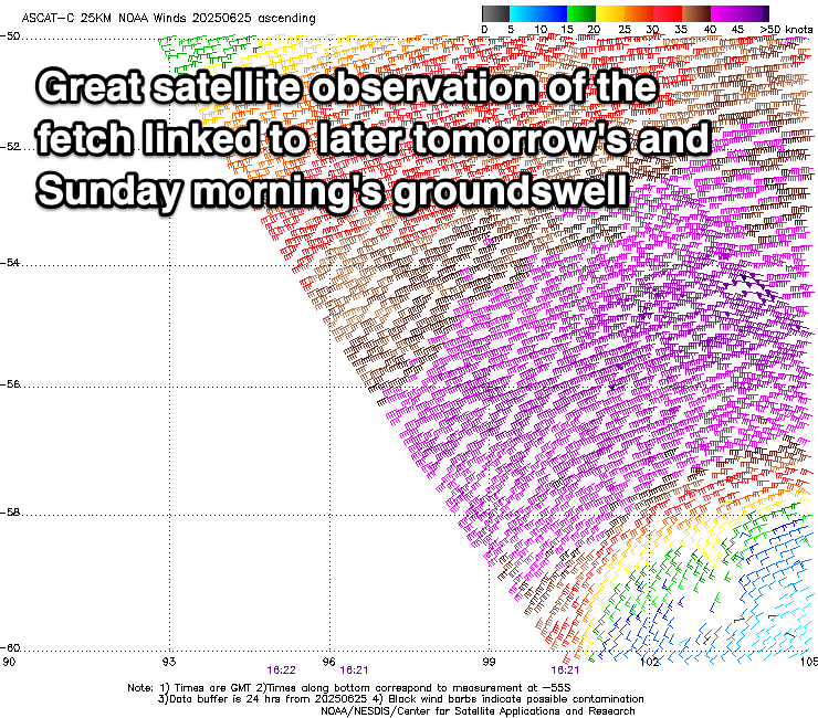
There’ll also be some inconsistent W/SW groundswell later tomorrow and Sunday morning from the earlier stages of the low when more in the southern Indian Ocean, with that energy currently impacting Western Australia today.
Middleton should come in at 3-4ft tomorrow morning with 1-2ft sets inside the gulf, pulsing later to 4-5ft and 2ft respectively before easing back from 3-5ft and 2ft Sunday morning.
Winds have taken a turn for the worse for the South Coast on Sunday, with a trough expected to move in before dawn, but looking at tomorrow and we should see light N/NW tending moderate W/NW winds on the South Coast, with light to moderate E/NE tending N/NE then variable N/NW winds across the Mid Coast.
Sunday looks onshore with moderate to fresh S/SW-SW winds on the South Coast, while the Mid Coast should see variable offshore winds in the morning, fresher S-S/SW into the afternoon.
Moving into next week and winds will ease and likely tend light E/NE across the South Coast Monday morning, with lots of lump and peakiness to the swell before S/SE-SE sea breezes kick in.
A reinforcing pulse of moderate sized S/SW swell is due though, generated by a trailing fetch of strong W/SW winds behind the weekend’s swell generator, with the South Coast expected to offer 4ft sets off Middleton, easing through the day, tiny and 1-1.5ft across the Mid Coast.
A temporary low point is due Tuesday morning, but into the afternoon, a new pulse of small to moderate sized SW groundswell is due, with a secondary stronger pulse expected Wednesday.
These swells will be generated by back to back fetches along the polar shelf, swinging in from the Heard Island region over the coming days. An initial pre-frontal fetch of W/NW gales will be followed by stronger but tighter, gale to severe-gale W’ly winds.

Tuesday afternoon’s increase should pulse to 3ft across Middleton, with Wednesday’s coming in at a better 3-4ft with tiny waves inside the gulf.
Local winds and conditions look good though, variable offshore Tuesday morning ahead of weak sea breezes, and N/NW tending W/NW-NW through Wednesday.
Into the end of the week we should see easing levels of swell with strengthening N’ly winds ahead of a possible incoming mid-latitude frontal progression, bringing some new W/SW swell for next weekend and beyond.
More on this Monday. Have a great weekend!
Comments
Woulda hurt missing that set poor fellas looked a lot better then what it was was very weak leftovers looked great had not
Much push even on the right side of tide