Improving surf tomorrow, great over the weekend
South Australian Forecast by Craig Brokensha (issued Wednesday June 25th)
Best Days: Tomorrow both coasts (best South Coast from later morning), South Coast Friday, South Coast Saturday (Mid Coast afternoon), both coasts Sunday (Mid Coast early and late)
Features of the Forecast (tl;dr)
- Easing mix of W/SW and SW swells tomorrow with variable offshore winds, variable into the PM
- Small-mod sized S'ly swell Fri AM, easing with light N/NE tending N/NW winds
- Moderate sized pulses of SW groundswell building Sat, peaking later, easing Sun
- Inconsistent W/SW groundswell also in the mix later Sat and Sun AM
- N/NW tending W/NW winds down South Sat, light-mod E/NE tending N/NE then lighter N/NW on the Mid
- N/NW tending W/NW winds down South Sun, light-mod NE tending light N/NW on the Mid
- Reinforcing S/SW groundswell Mon with early variable winds, freshening from the S/SE
- Moderate sized S/SW groundswell for Tue PME/Wed AM with S/SE winds
Recap
The Mid Coast built to a stormy 4-5ft through yesterday afternoon as a cold, strong mid-latitude low swept across the state, causing widespread damage, especially across the South East. The South Coast was small and wind affected, while today’d we’ve seen the swell jump as the backside of the progression aimed a strong SW fetch up into the region.
Conditions are poor across both coasts with strong but slowly abating onshore winds.
This week and next (Jun 26 - Jul 4)
The strong, mid-latitude frontal progression linked to the current weather and onshore surf is pushing further east and with this we’re set to see winds really back off overnight while tending more S’ly, weaker again tomorrow morning and becoming variable offshore across both coasts.
We’ll still have plenty of size left in the mix with the Mid Coast expected to ease back from 2ft to possibly 3ft early, smaller through the afternoon with lumpy but improving 3-5ft surf down South. Winds look to remain variable all day and this should result in any early lump down South ironing out through the day, really fun into the afternoon.
Now, into Friday, our S’ly swell due from a fetch of S/SW gales on the polar shelf last night looks to be a little smaller and weaker, with the fetch being more mobile resulting in fun, easing surf from 3ft with the Mid Coast coming in tiny.
Local winds will be great again and light N/NE tending N/NW down South, with the Mid Coast seeing a touch of northerly bump through the day before winds go variable later.

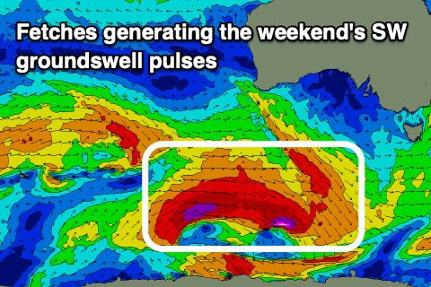
We then look to the weekend’s SW groundswell and the east-southeast tracking low from the southern Indian Ocean, linked to this swell, is now currently positioned south-west of Western Australia and east-northeast of the Heard Island region.
This system will continue tracking towards the polar shelf today, aiming a great fetch of W/SW gales through our south-western swell window before re-strengthening tomorrow. An additional fetch of stronger severe-gale to near storm-force W’ly winds are due to projected east, with two separate pulses of SW groundswell due, the strongest and best into later Saturday/Sunday morning.
Saturday morning looks to come in smaller but still a good 4ft across Middleton with the Mid Coast offering 1-1.5ft waves, while the stronger groundswell should fill in through the afternoon with sets to 5ft expected across Middleton, 2ft across the Mid.
There's also due to be some inconsistent W/SW groundswell energy in the mix later Saturday and Sunday morning, favouring the Mid Coast, generated by the earlier stages of the frontal progression in our distant westerly swell window.
Both swells are then due to start easing Sunday from a similar size, smaller Monday but slowed by some reinforcing S/SW swell across the South Coast, generated by a strong trailing front on the backside of the low Friday.
Looking at the local winds and N/NW tending W/NW winds are due Saturday across the South Coast with E/NE tending N/NE then light N/NW breezes across the Mid Coast, similar Sunday but more NE across the Mid Coast early.
As the swell eases back from the 4ft range across the South Coast Monday (tiny Mid Coast), a trough looks to bring freshening S/SE winds, possibly variable at dawn.
Longer term, another good pulse of longer-range SW groundswell is due Tuesday afternoon/Wednesday but with what looks to be onshore S’ly winds feeding into a low forming off the East Coast, more on this Friday.

