Large, windy swell inbound, better from later week

South Australian Forecast by Craig Brokensha (issued Monday June 23rd)
Best Days: Thursday Mid Coast, Friday South Coast, Saturday/Sunday both coasts, Monday South Coast
Features of the Forecast (tl;dr)
- Large, stormy W'ly swell developing tomorrow PM, easing Wed
- Large SW swell for the South Coast Wed, easing Thu
- Strong W/NW tending W/SW winds tomorrow, strong SW but easing Wed
- Variable offshore winds Thu AM ahead of weak sea breezes
- Moderate sized S'ly groundswell Fri AM, easing with light, local offshore winds and weak sea breezes
- Moderate to large sized SW groundswell Sat, with a reinforcing W/SW swell for the PM and Sun AM
- Light, local offshore winds ahead of weak sea breezes Sat/Sun
Recap
Early Saturday was small and clean with fun options across the South Coast but into the afternoon our new, inconsistent groundswell filled in, offering great waves for the late session as winds tended variable. The Mid Coast improved as northerly winds backed off and the swell kicked to a fun but inconsistent 2ft.
Yesterday the swell was on the ease with choppy, wind affected waves inside the gulf, better down South before bottoming out this morning.
This week and weekend (Jun 24 - 29)
Looking to the west and a strong mid-latitude frontal progression is moving in, with fetches of strong to gale-force W/SW winds being projected through our western swell window.
This should kick up an increase in mid-period W’ly swell today along with strengthening N’ly winds, with the bulk of the energy due tomorrow across the Mid Coast, biggest down South Wednesday.
This will be thanks to the strongest of the frontal systems moving under Western Australia and through the Bight today, generating W/SW gales before then projecting a more SW fetch into the South Coast tomorrow afternoon/evening.
The Mid Coast looks to build to a stormy 3-5ft tomorrow afternoon with strong W/NW tending W/SW winds, while the South Coast only looks to build to 4-5ft later in the day when winds go more onshore, smaller but cleaner in protected spots through the morning.
Come Wednesday, the Mid Coast will be easing but still likely 3-4ft with strong but abating SW winds, choppy and 4-6ft or so across the South Coast.
Thursday looks to see improving conditions as winds tend variable across the South Coast though there’s likely be lots of lump still in the mix from Wednesday’s with easing sets from 4-5ft across Middleton.
The Mid Coast looks like the pick under offshore winds and with easing 2ft to occasionally 3ft sets.

The surf will continue to ease into Friday, but a new S’ly groundswell is due overnight Thursday, offering a little more strength to the dropping energy.
The source will be a polar fetch of S/SW gales sitting south-southwest of Tasmania through tomorrow, with Middleton due to ease back from 3ft while the Mid Coast looks to become tiny.
Light, local offshore winds are due Friday morning with much cleaner conditions across the South Coast, with sea breezes only due to be light if not variable..
Looking at the weekend outlook, and our good groundswell flagged through last week is on track.
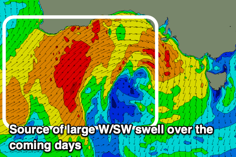
A strong mid-latitude low that’s currently south-east of Madagascar is generating gale to severe-gale S/SW winds, aimed out of our swell window, but it’s due to track east-southeast over the coming days while strengthening. This will see a fetch of severe-gale W/SW winds aimed through our western swell window while dipping south-east of Western Australia, generating some long-range, inconsistent W/SW groundswell for later Saturday/Sunday, but it’s the developments once it continues tracking south of the country that are of more interest.
The system is due to strengthen south of WA, a polar latitudes this Wednesday/Thursday, with a great fetch of severe-gale to possibly storm-force W’ly winds being projected through our south-western swell window.

This will generate a moderate to possible large sized SW groundswell for Saturday, coming in at 4-6ft across Middleton while the Mid Coast should offer 1-2ft waves, pulsing more to 2ft into the afternoon as the W/SW energy arrives.
The South Coast will start to ease Sunday, while the Mid Coast holds 2ft, easing in size and consistency later, smaller again Monday.
Winds look locally offshore on Saturday morning ahead of weak sea breezes, similar Sunday.
Following this we’ve got easing surf into early-mid next week under offshore winds for the South Coast ahead of some new W/SW groundswell later week.