Slowly improving surf ahead of large swells next week

South Australian Forecast by Craig Brokensha (issued Wednesday April 30th)
Best Days: South Coast for the keen Friday morning but more so Saturday, South Coast Monday, both coasts possibly Tuesday
Features of the Forecast (tl;dr)
- Weak, small surf tomorrow and Fri
- Moderate E/NE tending SE winds tomorrow
- Moderate N/NE tending E/SE Fri
- Inconsistent but better S/SW groundswell Sat AM, easing, tiny Sun
- Fresh N/NE tending weaker N/NW winds Sat, similar Sun but a little stronger
- Large W/SW groundswell building rapidly Mon, peaking into the PM with strengthening N-N/NW tending NW winds
- Likely large reinforcing SW swell Tue with winds unkown
Recap
The Mid Coast continued to offer 1-1.5ft sets through yesterday while the South Coast was a little lumpy but fun with variable winds and 2-3ft sets off Middleton.
Today the surf is back down a little more inside the gulf with lumpy, windswelly conditions across the South Coast. Winds will shift back S/SE and freshen through the day.
This week and next (May 1 - 9)
Tomorrow looks to be a similar but smaller version of today on the South Coast, with this afternoon’s S/SE winds due to ease off and shift E/NE during the morning, back to the SE into the afternoon.
Into Friday, cleaner conditions are due with a N/NE offshore but the swell looks small and to an inconsistent 2ft off Middleton with tiny waves inside the gulf.

Later in the day but more so Saturday morning, a new pulse of S/SW groundswell is due, generated by a strengthening fetch of W/NW gales tracking south-east towards the polar shelf today. This frontal system will actually spawn into a low, with slightly stronger severe-gale W’ly winds due to be generated on its tail, late in our swell window.
It’ll be inconsistent but good 2-3ft sets are due off Middleton Saturday morning (tiny Mid Coast) under fresh N/NE winds that will weaken and tend N/NW into the afternoon as the swell eases.
Similar but slightly stronger winds are due Sunday but with tiny, fading surf.
We then look at the large, long-period W/SW groundswell due to arrive into Monday next week, with a peak due through the afternoon.
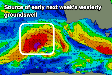
As touched on Monday's notes, a significant polar frontal progression is expected to fire up towards Western Australia later this week, under the influence of a strong node of the Long Wave Trough.
We’re set to see a fetch of severe-gale to storm-force W/SW-SW winds projected through our western swell window, with the storm weakening on approach to the Bight through the weekend.
This will generate a large, long-period W/SW groundswell that’s due to arrive Monday and build rapidly to 3-4ft on the Mid Coast through the afternoon with Middleton reaching 4-5ft+.
Local winds will be best for the South Coast with strengthening N/NW breezes, shifting NW mid-afternoon and then W/NW after dark.
This will be thanks to a secondary strong frontal system moving in from the south-west bringing with it a reinforcing, moderate to large W/SW-SW groundswell for Tuesday.
The models diverge regarding the timing and intensity of this system, with ECWMF clearing it quicker to the east on Tuesday resulting in variable winds while GFS has fresh W/NW-SW winds.
With this divergence and uncertainty on follow up activity, we’ll have to review the outlook for the rest of the week on Friday, but it looks generally moderate to large in size with NW to SW winds Wednesday, shifting S/SE later week. See you back here Friday.
Comments
How's the water quality?