Good Mid Coast run continues

South Australian forecast by Craig Brokensha (issued Monday January 13th)
Best Days: This morning both coasts, Mid Coast Thursday and Friday morning, both coasts Sunday/Monday
Features of the Forecast (tl;dr)
- Easing swell tomorrow with variable winds ahead of sea breezes
- Small to moderate sized, inconsistent W/SW groundswell building Wed PM (mixed with windswell on the Mid), peaking Thu
- Additional mid-period W/SW swell for Thu, easing Fri
- Strong W/SW-SW winds Wed, fresh S Thu (tending S/SE early/late on the Mid)
- E/SE tending SW winds Fri
- Smaller Sat with E/NE-NE tending S/SE winds down South
- Moderate sized, inconsistent W/SW groundswell building Sun, easing slowly Mon
- Variable winds ahead of sea breezes Sun, similar Mon AM ahead of a S/SW change
Recap
The South Coast was onshore and poor all weekend, while the Mid Coast was tiny on Saturday ahead of our inconsistent W/SW groundswell through yesterday.
While slow through the morning, the Mid kicked to a good 2ft with workable sea breezes yesterday afternoon, and this morning the tail of the swell is wagging much stronger than expected. The Mid is seeing easy 2ft+ waves on the dropping tide but sea breezes will spoil the afternoon/evening session.

Bomb set this morning and way more size than expected
This week and weekend (Jan 14 - 19)
A trough is due to move through this evening but it won’t have any major strength, leaving variable winds across both coasts tomorrow, tending light offshore across the Mid Coast.
The current swell will continue to drop but the Mid Coast will likely continue to see infrequent 1ft+ sets, with easing 2ft waves off Middleton.
Moving into Wednesday and our new, long-range W/SW groundswell is due to fill in, generated by a strong low that formed to the south-east of South Africa last week.
The low projected east while generating significant fetches of gale to storm-force winds, with the remnants currently pushing towards Western Australia today.
The groundswell should build to an inconsistent 1-2ft across the Mid Coast through Wednesday afternoon, while the remnants will generate some better reinforcing W/SW swell for Thursday more to 2ft+.

Middleton should build to 3ft into the afternoon Wednesday, holding a similar size on Thursday but local winds will be less than ideal for both coasts.
This will be thanks to a strong W/SW tending SW change moving through Wednesday (bringing some additional windswell to the Mid Coast), with fresh S/SW-S winds left into Thursday.
The Mid should see early and late S/SE winds on Thursday, smaller Friday but still 2ft on the sets with a morning E/SE offshore.
Saturday will become cleaner down South as winds tend E/NE-NE through the morning but it will still be very lumpy and peaky with easing surf from 2ft+ across Middleton.
Moving into Sunday and a mix of long-range W/SW groundswells are due to fill in, with a peak expected through the afternoon and into Monday morning.
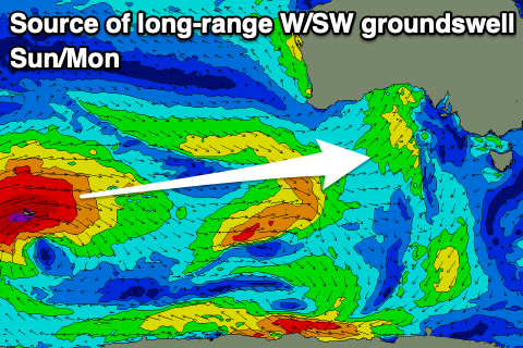
The source is another strong frontal progression in our far swell window, south of the Indian Ocean. This progression will project multiple fetches of gale to severe-gale winds through our long-range swell window, weakening on approach to Western Australia again.
This should generate a moderate sized swell that should build to an inconsistent 2ft across the Mid Coast Sunday and ease from a similar size Monday with 3-4ft sets off Middleton.
Local winds at this stage look locally offshore on Sunday morning ahead of sea breezes, similar Monday morning ahead of a trough and S/SW change. More on this Wednesday.
Comments
Why are they building a small rock wall at dumpers?
Seems odd?
And dangerous!
I think it's designed to keep people away from that corner of the beach while they finish the new walkway that runs from Porties around to the dunnies at the end of Beach Road - if I'm wrong and it's meant to be permanent what a stupid idea, a solid dumpers stormy already packs some decent punch, imagine getting slammed on those rocks?! Bugger that!