Best early next week across the South Coast

South Australian Forecast by Craig Brokensha (issued Friday March 22nd)
Best Days: Mid Coast today, South Coast Monday and Tuesday mornings
Features of the Forecast (tl;dr)
- Moderate sized, mid-period S/SW swell tomorrow and Sun
- Fresh SE winds, tending stronger S tomorrow
- Moderate to at times fresh S/SW-S winds Sun
- Moderate sized mid-period S/SW swell Mon AM ahead of a larger S/SW groundswell into the afternoon/evening, easing slowly Tue
- Light NW winds down South, E on the Mid ahead of sea breezes Mon, similar Tue
- Easing swell Wed with S/SE winds
- Smaller Thu with fresh E/SE tending S/SE winds
- Small Fri with NE tending SE winds
Recap
The Mid Coast has held onto a touch more size than expected through yesterday and today, with good 1-2ft waves yesterday, backing off to a tinier 1-1.5ft today. The South Coast has hovered in the 3ft range and yesterday's expected E/NE winds in the morning, backed up again today for a brief period, offering OK waves for the keen.
This weekend and next week (Mar 23 - 29)
Looking at the weekend ahead, and new levels of mid-period S/SW swell are due through both Saturday and Sunday owing to a healthy polar frontal progression the last couple of days, south of the country.
A slight lift to 3ft+ is due tomorrow across Middleton, with tiny 0.5-1ft sets on the Mid Coast and winds look less favourable as a trough bringing today's freshening S/SE winds sits just east of us, bringing fresh SE winds, strengthening from the S'th later in the day.
Moderate to at times fresh S-S/SW winds will persist into Sunday along with similar sized surf to Saturday. All in all it looks like a poor weekend of surf across the state.
Moving into next week, our larger S/SW groundswell is still on track, generated by a strong polar low that's due to form south of Western Australia today. A fetch of gale to severe-gale W/SW-SW winds will project up towards Tasmania, through our southern swell window.
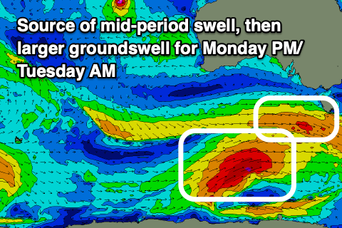
The timing of the large S/SW groundswell looks to be into the afternoon Monday, with moderate amounts of mid-period S/SW swell likely in the morning to 4ft+ or so.
We should see Middleton building to a large 6ft+ by dark, with the Mid Coast only likely to come in at 1ft.
Into Tuesday, the groundswell should ease back from a similar 6ft, though there'll also be some mid-period SW energy in the mix, generated by a strengthening frontal system passing south of us on Sunday and early Monday. The swell from this system looks smaller than the S/SW groundswell though still 4-5ft by itself across Middleton with 1ft sets on the Mid Coast.
Winds are still expected to improve and shift NW across the South Coast Monday morning, E'ly on the Mid Coast ahead of local sea breezes.
Tuesday looks similar with variable tending light, local offshore winds before afternoon sea breezes develop.
Make the most of these windows as Wednesday will see S/SE winds kick back in as the swell eases. They'll only be moderate but there and with easing 3-4ft of S/SW swell.
Into the end of the week, smaller surf is due with fresh E/SE winds on Thursday morning, NE Friday but without any real size.
Next weekend looks generally small to start with, but some inconsistent W/SW swell may be seen into Sunday/Monday from a strong but distant frontal progression pushing up high into the Indian Ocean. The models still diverge regarding the structure of this progression but it looks like S/SE winds will favour the Mid Coast which could come in at 1-2ft. More on this Monday. Have a great weekend!