Good run for the South Coast with a few runners in the gulf

South Australian Forecast by Craig Brokensha (issued Friday March 8th)
Best Days: South Coast tomorrow, Sunday, Monday and Tuesday morning, Mid Coast Monday for the keen, Wednesday Mid Coast
Features of the Forecast (tl;dr)
- Slowly easing SW swell tomorrow with fresh N/NE tending weaker N/NW winds into the PM, variable later
- Smaller Sun AM ahead of a late pulse of new SW groundswell and possible W/SW swell
- N/NE tending NW winds, then sea breeze Sun, variable late
- Peak in W/SW swell Mon and SW groundswell in the AM, then easing
- Moderate N/NE winds Mon AM, tending N/NW ahead of possible late sea breezes
- Easing surf Tue with variable morning winds and afternoon sea breezes
- Moderate + sized SW groundswell Wed with S/SE-SE winds, easing Thu with SE tending S/SE winds
Recap
Generally poor surf yesterday with onshore winds down South and a building swell, clean but near flat on the Mid Coast before pulsing into the afternoon and holding today to 1.5ft generally, with the odd 2ft set in the mix. The incoming tide should provide 2ft sets but with sea breezes.
The South Coast was stronger and to 3-4ft this morning (now an easy 4ft) with light winds that will also go sea breezy.

Solid sets down south at midday today
This weekend and next week (Mar 9 - 15)
Today's W/SW swell energy will have a bit of longevity to it, thanks to the progression that generated being two staged elongated.
This should maintain 3ft+ sets across Middleton tomorrow morning, easing back from 1ft+ across the Mid Coast.
Winds will favour the South Coast tomorrow morning with a fresh N/NE'ly shifting N/NW into the afternoon and then variable later ahead of a shallow, evening change.

The change will be quite weak, with winds due to swing back to the N/NE Sunday morning with small 2ft sets across Middleton. Winds should tend N/NW ahead of weak sea breezes down South, with N/NW tending SW winds on the Mid along with a late pulse of W/SW swell energy (more so Monday).
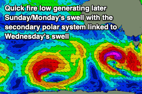
The source of this swell is a rapidly deepening mid-latitude low under Western Australia this evening and early tomorrow.
A tight and fast moving fetch of severe-gale to storm-force winds (at its core) are due to be projected through our south-western swell window, though during today a fetch of strong W/SW winds will be generated in the Mid Coast's swell window.
What we should see Sunday afternoon is the SW groundswell energy filling in, with the mid-period W/SW swell energy arriving overnight and peaking Monday on the Mid Coast.
Building surf to 1-1.5ft is likely later on the Mid Coast with 3ft+ sets across Middleton, better Monday and to 1-2ft and 4ft respectively, easing through the day.
Winds will favour the South Coast and be N/NE again in the morning with small bumps on the Mid, and winds should again tend NW through the early afternoon ahead of possible late sea breezes.
Smaller surf should be seen Tuesday with morning variable winds.
All in all this looks to be a great run for the South Coast with workable runners across the Mid for the keen.
Our secondary pulse of SW groundswell for Wednesday is on track, but so are the expected S/SE-SE winds, favouring the Mid Coast which will be on the small side.
Coming back to the swell, and a slow moving polar low forming just east of the Heard Island region today should generate a moderate + sized pulse of groundswell energy that should come in at 4-5ft+ across the South Coast, and 1ft to possibly 2ft in the gulf.
Unfortunately SE winds look to linger as the swell eases Thursday, but there'll be plenty of opportunities to surf the South Coast ahead of this. Have a great weekend!