Fun W/SW swell later week

South Australian Surf Forecast by Craig Brokensha (issued Monday January 8th)
Best Days: Thursday morning for the keen down South and on the Mid Coast, Friday morning both coasts, Saturday morning both coasts
Features of the Forecast (tl;dr)
- Small surf tomorrow, fading Wed
- Light S/SE winds tomorrow, freshening, variable N/NE Wed AM ahead of a shallow S/SW change
- Small-moderate sized mid-period W/SW swell building Thu, peaking Fri
- Moderate E/SE-E winds Thu AM ahead of sea breezes
- E/NE winds on the Mid Fri AM, N/NE down South ahead of sea breezes
- Easing surf Sat with variable winds ahead of a strong S/SE change
Recap
The weekend provided funky winds and weather thanks to an inland surface trough drifting south-east across the state, but the magnets offered fun waves with the most size seen Saturday to 3ft+, smaller yesterday along with a smaller window of clean conditions.
The backside of the trough moved in earlier than expected and this brought freshening SW winds mid-morning, with poor surf thanks to a strengthening S/SW breeze seen today.
The Mid Coast was tiny for beginners, bumpy today.
This week and weekend (9 - 14)
The coming forecast period will consistent of generally small to moderate sized surf with tricky, varying winds thanks to persistent troughy weather.
Some new, background SW swell that's in the water today is due to ease tomorrow and winds will quickly back off though linger out of the S/SE, creating less than ideal conditions. With the small 2ft of swell across Middleton it won't be worth worrying about.
Wednesday looks smaller and back to 1-2ft but with cleaner conditions with a variable N/NE offshore before a trough brings a shallow S/SW change late morning.
Behind this trough, E/SE-E winds will develop on Thursday morning along with a building mid-period W/SW swell that's expected to peak Friday morning.
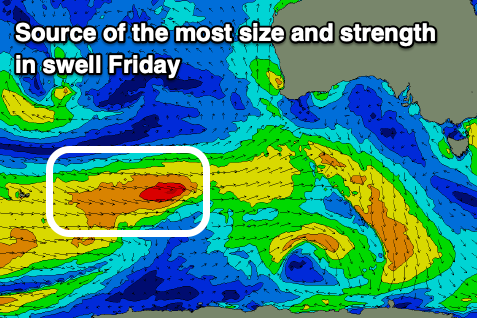
The source is a relatively weak but persistent frontal progression moving in from the south-west of Western Australia. It'll be a little better positioned through the Mid Coast's swell window, with the activity positioned a little further north and this should see some fun, novelty waves popping up.
Strong W/SW winds are due within the frontal progression for the most part with a small burst of stronger gales through this evening, generating the peak Friday morning.
Middleton should build to 3ft on Thursday afternoon, easing a little from a similar size Friday morning. The Mid Coast should see 1-1.5ft waves developing Thursday, similar Friday though with more chance of 2ft sets.
As touched on, winds will be less than ideal though workable on the South Coast, clean in the gulf ahead of sea breezes on Thursday with Friday seeing E/NE winds on the Mid, N/NE to the south ahead of afternoon sea breezes again.
Easing surf is due into the weekend and winds look variable offshore again before a trough brings a stronger S/SE change. The Mid Coast should still be 1-1.5ft though easing with Middleton dropping back from 2-3ft.
A strong high filling in behind the trough will bring strong S/SE winds and some localised, stormy S/SE windswell which will ease early next week but with no major swells to follow. With this, make the most of the small windows this week.