Poor end to the week, cleaner conditions from the weekend

South Australian Forecast by Craig Brokensha (issued Wednesday January 3rd)
Best Days: Keen surfers late Friday down South, South Coast swell magnets Saturday and Sunday mornings, Monday morning South Coast, Wednesday morning South Coast
Features of the Forecast (tl;dr)
- Small mix of S windswell and background mid-period S/SW energy over the coming days, easing Sat, smaller Sun
- Mod-fresh S/SE winds tomorrow
- Moderate S/SE winds Fri, tending lighter SW later
- NE-N/NE tending S/SW winds Sat
- NE tending NW, then W/NW winds Sun ahead of a late change
- Late increase in small-moderate sized mid-period SW swell Sun, peaking Mon, with a slightly better pulse Tue PM, easing Wed
- W/NW tending fresh SW winds Mon
- SW winds Tue
- N/NE tending SE winds Wed
Recap
Weaker onshore winds created OK waves for desperate surfers down South yesterday with a mix of swells to 2-3ft, building a little more into the afternoon. Today is similar and not great but surfable for the super keen. The Mid Coast has been tiny.
This week and weekend (Jan 4 - 7)
Looking at the end of the week and unfortunately a trough approaching from the west will bring a moderate to fresh S/SE change tomorrow morning which will create poor conditions across the South Coast along with a mix of background S/SW swell and localised, building S windswell.
Winds are due to ease on Friday but remain moderate from the S/SE, with bumpy, average surf for the desperate, possibly improving later as winds ease and tend more SW into the evening.
The weekend looks much better as conditions improve thanks to a broad, inland low drifting south-east across the state, shifting winds around to the N/NE-NE on Saturday morning (ahead of S/SW sea breezes), and N/NE tending NW on Sunday morning and W/NW into the afternoon.
Swell wise, a mix of easing S/SE windswell and background S/SW swell are due on the weekend, biggest Saturday morning and to 2ft, with Sunday coming in at a smaller 1-2ft across Middleton. Hit the magnets.
Later in the day Sunday, some new mid-period SW swell may be seen, generated by a healthy fetch of strong to near gale-force W/NW winds forming to the south-west of Western Australia today.
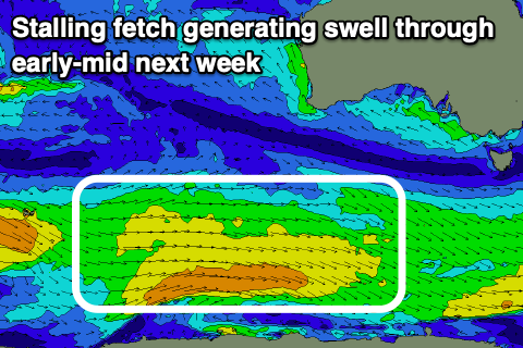
The frontal system linked to this fetch will become slow moving, stalling on the polar shelf but in a weaker form through Friday and Saturday, prolonging the swell through early next week and giving it an additional boost in size.
The first pulse for later Sunday and Monday looks to be 2-3ft across Middleton, with the secondary pulse more to 3ft Tuesday afternoon and Wednesday morning. The Mid Coast doesn't look to top 0.5-1ft owing to the south direction of the swell.
Winds on Monday look to remain favourable for the South Coast and W/NW ahead of a fresh SW change during the day, with S-S/SE winds due to follow into Tuesday. We may see winds shift back to the N/NE next Wednesday but check back here on Friday for the latest outlook.
Comments
Any old timers on here ever remember it being as rocky at Knights as it is now? All the sand has been stripped.
I checked it out last week and couldn't believe my eyes! Crazy eh.
I remember as a kid it being like that one summer as we'd swim in the rock pools in the exposed rock above the tide line towards Boomers, but never saw it again when hitting the beach. It's radical.
Yeah I don’t think I’ve seen anything like it before. Admittedly I’ve only surfed that stretch over this time of year for the last 14 or so years but never remember it being like that when I lived in SA.
Fair bit of rock exposed along the Boomer stretch too.
Chiton area seems normal.
Yes it comes and goes all the time
Here are some images..
All of those rocks are usually covered by sand most of the time.
I’ve never seen the rocks that exposed in 27 years even prior as a grommet! Wait till you see the ever so rare waterfall flow from the cliff from rain stormwater run off!
Yeah lines up with out observations as well eh!
All those strong southerly bouts along with lots of southerly swell has smoked it.
Any other regions similar? Petrels didn't seem as noticeable but I didn't check the beach close-up, just on a drive by,