Strong swells inbound with favourable winds

South Australian Surf Forecast by Craig Brokensha (issued Monday July 24th)
Best Days: Today, tomorrow, Wednesday (morning Mid Coast), Thursday South Coast, Saturday South Coast, Sunday morning South Coast
Features of the Forecast (tl;dr)
- Mod-large W/SW groundswell for tomorrow, with a larger SW pulse later, easing Wed
- Local offshore winds and weak sea breezes tomorrow, local offshore tending variable Wed
- Easing surf Thu with strengthening N/NE tending N/NW winds
- Low point in swell Fri AM with W/NW tending W/SW winds
- Moderate sized, mid-period S/SW swell Sat with N/NE tending N/NW winds
- Easing swell Sun with N/NW tending W/NW winds
- Large W/SW groundswell for early next week
Recap
Great conditions Saturday with clean 3ft waves off Middleton, lumpy and to 1-2ft across the Mid Coast as we fell in between swells.
Sunday provided a new pulse of W/SW swell with S-S/SE winds, favouring protected spots on the Mid Coast while the South Coast was poor and back to 2-3ft.
Today conditions are nice and clean across both coasts with fun, glassy 2ft sets on the Mid Coast, lumpy and 2-3ft off Middleton.

Good surf this morning
This week and weekend (Jul 25 - 30)
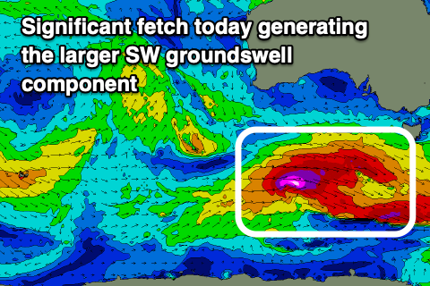
All eyes are on the coming days when a strong mix of large W/SW and SW groundswells are due to fill in, with the two possibly destructively interfering at times providing funky double ups more so into tomorrow afternoon if anything.

This is the only possible downside to the coming days, with a broad, complex low generating a mixed fetch of pre-frontal, severe-gale W/NW winds, with tighter storm-force W'ly winds around a small low pressure centre on the weekend.
This was east of the Heard Island region (more aligned with our western rather than south-western swell window) and the remnants of the complex low are now re-strengthening south of the country, with an additional fetch of severe-gale to storm-force W'ly winds now moving through our south-western swell window.
What this will result in is a moderate to large, inconsistent W/SW groundswell for later today, peaking tomorrow morning, with a larger, more consistent SW groundswell due later in the day, peaking overnight, easing Wednesday.
The Mid Coast should come in at an inconsistent 2ft with the possible rare bigger one tomorrow while the South Coast offered 6ft sets across Middleton with the larger pulse of groundswell pushing to 6ft+ late, easing from 6ft Wednesday morning.
Winds tomorrow will again favour both coasts with a light, local offshore breeze from the N/NE down South, E/NE on the Mid ahead of weak afternoon sea breezes. Wednesday will see winds play out similar though tend more NE on the Mid through the morning (with easing 2ft sets), variable across both coasts into the afternoon.
Strengthening N/NE tending N/NW winds are due on Thursday as the swell drops away, best down South with easing 3ft+ sets across Middleton.
A low point in swell looks to occur on Friday morning and a morning W/NW wind will limit options to save the energy.

On Saturday a fun sized, mid-period S/SW swell is due, generated by a polar front moving along the shelf over the coming days. A boost back to 3ft is due across Middleton with tiny waves across the Mid Coast.
Winds should be favourable and N/NE tending N/NW, with N/NW tending W/NW winds on Sunday as the swell starts to ease.
Longer term, as touched on in last week's notes, a significant Southern Ocean frontal progression forming east of the Heard Island region later this week looks to produce a moderate to more likely large W/SW groundswell for early next week but we'll have a closer look at this on Wednesday.