Fun southerly swell tomorrow

South Australian Surf Forecast by Craig Brokensha (issued Monday June 19th)
Best Days: Today protected spots South Coast, tomorrow South Coast, early Wednesday South Coast, Friday for the keen South Coast, likely South Coast Sunday/Monday
Features of the Forecast (tl;dr)
- Moderate sized S'ly swell tomorrow AM, easing into the PM and small, fading Wed
- Moderate N/NE winds tomorrow, strong N/NE on Wed
- Small, inconsistent SW swell Fri with gusty NW tending N/NW winds
- Fading swell Sat, with a NW windswell on the Mid under strong N/NW winds
- Possible building W/SW swell Sun, easing Mon with NW winds
Recap
Poor, choppy waves building in size across the Mid Coast through Saturday but with no real quality, easing Sunday with similar, choppy conditions. The South Coast faired much better with good 3-4ft sets across Middleton, holding yesterday and again similar today.
Conditions were favourable most of the weekend down South with protected spots fairing the best but with a little less size and consistency.
This week and weekend (Jun 20 - 25)
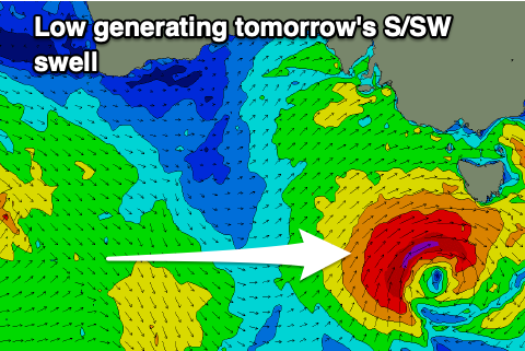
The final front in a progression of strong systems, spinning around a broad Southern Ocean gyre is passing under us today, and it's spawned a low pressure system directly west of Tasmania.
With this, a fetch of strong to gale-force SW winds were generated in our southern swell window, producing a final reinforcing S'ly swell for tomorrow to a good 4ft across Middleton, easing back through the afternoon and then down from a much smaller 2ft+ on Wednesday morning.
The Mid Coast will become tiny and fading from 1-1.5ft tomorrow, near flat on Wednesday.
Conditions will be excellent for the South Coast tomorrow with a moderate N/NE breeze, stronger Wednesday and holding from the N/NE, favouring the magnets.
A low point in swell is due on Thursday ahead of a small, inconsistent pulse of mid-period W/SW swell, generated by a patchy polar frontal system that's currently south-southwest of Western Australia.
No major size or consistency is due from this source with 1ft sets max on the Mid Coast and 2ft+ waves across Middleton, easing into Saturday from 1-2ft.

Winds will be good for the South Coast on Friday, strengthening from the NW tending N/NW with strong N/NW-NW winds on Saturday. This will kick up some local windswell on the Mid Coast from the NW to a choppy 2-3ft on Saturday.
Now, like the last few weekend's the swell will be on the build again, but from a poor direction and angle.
High-riding mid-latitude frontal activity doesn't look good at all for generating surf with very tricky westerly swells due into Sunday/Monday. Some better Southern Ocean frontal activity looks to back this up through the middle to end of next week.
The models diverge on this initial mid-latitude activity but winds will be poor for the Mid Coast regardless and cleaner in protected spots down South but with nothing major size wise. Check back here Wednesday for a clearer ideal on Sunday/Monday onwards.