Fading surf ahead of a large groundswell for the weekend

South Australian Surf Forecast by Craig Brokensha (issued Monday June 5th)
Best Days: Today South Coast, protected spots down South Friday, Saturday both coasts, Sunday South Coast
Features of the Forecast (tl;dr)
- Surf bottoming out over the coming days with strong N tending N/NE winds tomorrow, N/NE tending N/NW Wed
- Moderate + sized mix of mid-period W/SW swell and windswell building Thu on the Mid with strong W/NW winds
- Swell building down South Thu, peaking Fri with fresh W/NW tending W/SW winds
- Large, long-period SW groundswell building Sat, peaking later, easing Sun
- N/NW winds Sat (N/NE on the Mid), stronger N on Sun
- Strong W tending SW winds Mon with a mix of weak, building swells
Recap
Great conditions for selected spots on Saturday morning with 3-4ft sets easing back from Friday's groundswell pulse under a light NE breeze. Yesterday started off smaller and clean again ahead of a new pulse of S/SW groundswell into the afternoon. This has since backed off this morning from a smaller than expected 2ft+ or so.
The Mid Coast was clean but tiny to flat all weekend and today.
This week and weekend (Jun 6 - 11)
The surf will bottom out over the coming days thanks to the development of mid-latitude frontal activity towards Western Australia, and a blocking high setting up across the Southern Ocean during the weekend.
Winds will strengthen from the N'th tending N/NE tomorrow as a broad frontal progression currently over Western Australia starts pushing east, N/NE tending N/NW as it nears closer on Wednesday.
The front will push across us Thursday, bringing strong W/NW winds along with a building W/SW swell thanks to strong W/SW winds being generated through the Bight on Wednesday.
A mix of localised windswell and mid-period swell should build to 3-4ft on the Mid Coast through the afternoon Thursday, with the South Coast building to 3ft+ across Middleton.
With the frontal progression being elongated but dipping south-east through Friday the Mid Coast looks to ease back to the 3ft range on Friday as the South Coast holds 3-4ft across Middleton along with gusty W/NW tending W/SW winds.
Now, moving into the weekend, we're expected to see a large, long-period SW groundswell building through Saturday, peaking into the afternoon.
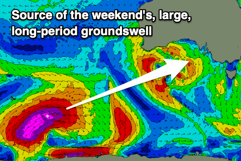
The source of this swell will be a great polar low forming in the Heard Island region today, generating a fetch of severe-gale to storm-force W/NW winds. The low will weaken while drawing out in length and scope, stretching up towards Western Australia tomorrow evening and Wednesday.
As it does so, severe-gale W/SW winds will tend more SW and weaken, then projecting east into us as the frontal system moving through Friday.
The long-period swell will build strongly on Saturday and looks to reach 6-8ft across the South Coast with 2ft waves on the Mid, easing back Sunday from 5-6ft across Middleton and 1ft to possibly 2ft on the Mid.
Now, with the frontal activity dipping south-east late week and into the weekend ahead of another weaker front pushing up across Western Australia, we're due to see excellent N/NW winds persisting all day Saturday down South, tending N/NE on the Mid Coast, with Sunday seeing stronger N winds.
The front will cross us on Monday bringing a W tending SW change and possible renewal in W'ly swell but we'll have a closer look at this on Wednesday. All in all it looks to be an epic long weekend of surf.