Little windows of lighter winds to target

South Australian Surf Forecast by Craig Brokensha (issued Wednesday February 8th)
Best Days: This morning ahead of the sea breeze, tomorrow morning ahead of the sea breeze, Friday for keen surfers, Mid Coast for the keen late Monday but more so Tuesday, South Coast Wednesday and Thursday mornings
Features of the Forecast (tl;dr)
- Easing S/SW swell tomorrow, further Fri. Variable (tending light offshore winds) ahead of S/SE sea breezes tomorrow
- NE tending W/NW winds into the early PM Fri, fresher W/NW-NW into the evening
- Strengthening W/NW tending W/SW winds Sat with a building windswell on the Mid
- Easing windswell Sun with strong S/SW-S winds (S/SE early on the Mid)
- Small, inconsistent mid-period W/SW swell building Mon, peaking Tue with mod-fresh E/SE tending S/SW winds Mon (S/SE late in the gulf), gusty SE tending S/SE Tue
- Reinforcing, inconsistent W/SW groundswell Wed PM and Thu AM, with morning NE winds ahead of S/SE sea breezes
Recap
Winds were a little better than expected yesterday morning on the South Coast with light E/NE breezes and a lumpy 3ft of swell across Middleton. Today conditions are similar with a morning E'ly wind and mid-period S/SW swell holding 3ft, while the Mid Coast is clean but flat.

Semi-clean conditions this AM
This week and weekend (Feb 9 - 12)
This morning will be worth making the most of down South before sea breezes develop later morning, with smaller surf due into tomorrow morning, dropping back from 2ft+ across Middleton.
Conditions should be nice and clean, if not a little morning sick with a variable tending light offshore wind tomorrow morning, giving into sea breezes late morning again, so surf before lunch.
Friday looks clean again with a moderate NE breeze, shifting W/NW around midday and holding into the afternoon and evening, but we'll be looking at small, fading sets from 1-2ft across Middleton. Try the magnets for any size and power.
This shift in winds to the west, which will freshen into Saturday will be linked to a small surface trough, come low pushing in from the Bight.
It isn't expected to generate any real swell, with a very weak fetch of W/SW winds sitting high in the Bight, producing a weak W'ly windswell for the Mid Coast Saturday to 1ft to at times 2ft through the afternoon.
The South Coast will be clean but tiny with nothing to really recommend across the state.
The low will clear east on Sunday, bringing gusty S/SW-S winds and cleaner conditions on the Mid with an early S/SE breeze, but tiny easing surf from 1ft+.
Unfortunately the trough will stall over towards Victoria, as a high sets up south-west of us, bringing moderate to fresh E/SE tending stronger S winds Monday and fresh SE tending S/SE winds on Tuesday.
This will create poor conditions for the South Coast, while the Mid Coast is due to see some inconsistent mid-period W/SW swell energy from Monday, peaking Tuesday.
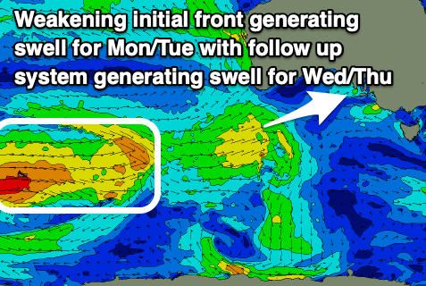
The source of this swell will be a weakening polar low projecting north-east from the Heard Island region today. A fetch of weakening W/SW winds will see some weak W/SW energy building on Monday, reaching 1-1.5ft through the day, holding Tuesday but with a greater chance for the odd 2ft'er on the favourable parts of the tide. In either case it'll be a touch windy and slow so not great.
Following this initial low, a stronger but similar weakening system will break down in our medium-range swell window, producing a tease of inconsistent W/SW groundswell energy for Wednesday afternoon and Thursday. Again it only looks to be 1-1.5ft on the Mid Coast with 2ft+ sets down South but with more favourable NE winds on the South Coast both Wednesday and Thursday.
Longer term we've got some stronger frontal activity on the cards for later next week, producing swell into next weekend, but more on this Friday.