Fun weekend, large swell for Monday

South Australian Surf Forecast by Craig Brokensha (issued Friday December 23rd)
Best Days: This morning both coasts (Mid Coast keen), tomorrow morning South Coast, Sunday morning South Coast, Monday morning South Coast, afternoon Mid Coast, Tuesday both regions, Thursday Mid Coast, Friday Mid Coast
Features of the Forecast (tl;dr)
- Moderate sized SW groundswell for today (peaking PM) with mod-fresh S/SW winds (SW Mid Coast and S/SE late)
- Easing swell Sat with variable winds ahead of sea breezes from late AM
- Fun mid-period S/SW swell building Sun with N/NE tending SE winds mid-late AM
- Large W/SW groundswell building rapidly Mon from late AM, peaking into the evening, easing Tue
- Variable winds, freshening from the S/SE Mon
- Gusty N/NE tending variable winds Tue
- Strong W/SW change after dawn Wed with a mix of easing S/SW swell and building windswell
- Moderate sized mid-period W/SW swell Thu with S/SE winds, easing Fri
Recap
Tiny surf across both locations yesterday with average winds down South, variable on the Mid through the morning. Into the afternoon the forerunners of a new, long-period groundswell started to show across both coasts, with it coming in at a better 1-1.5ft today on the Mid Coast with 3ft sets off Middleton. There should be the odd bigger one at the peak of the swell during the day down South and the quality of the swell is overriding the onshore breeze. Get out soon before the afternoon becomes bumpier.

Little gulf runners this AM
This weekend and next week (Dec 24 - 30)
Today’s inconsistent SW groundswell will peak this afternoon, with the easing trend being slow through the weekend thanks to the drawn out nature of the frontal progression linked to it. Tomorrow should still be an inconsistent 3ft on the sets across Middleton, 1ft on the Mid Coast.
A weak trough will clip us early tomorrow morning, but local land breezes should override the S/SW flow, resulting in variable winds and favourable conditions across both coasts. Sea breezes will kick in late morning so surf before then.
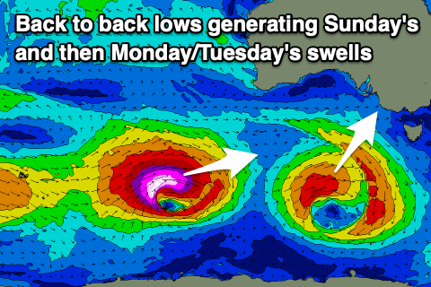
Into Christmas Day, we’ve got our new pulse of mid-period S/SW swell due to fill in, with it generated by a small but healthy low forming to the south-southwest of Western Australia last night.
A small fetch of strong to gale-force W/SW-SW winds should generate a good pulse of size, building to 3ft to possibly 4ft across Middleton, with 0.5-1ft sets on the Mid Coast. Winds will be great for the South Coast and N/NE through the morning, with sea breezes kicking in mid-late morning, so don’t dawdle.
Monday morning may see a temporary drop in size, back from 3ft across Middleton along with variable winds ahead of a S/SE change as a trough pushes through during the morning.
Now, unfortunately the timing of the change is right when a rapid increase in large, long-period SW groundswell is due, linked to a ‘bombing’ low forming east of the Heard Island today.
The catalyst for the ‘bombing’ low was a tropical depression being dragged south-east, into the westerly storm track from between Madagascar and South Africa. It’s dropping more than 24hPa within a 24 hour period and we’re seeing a great storm-force fetch of W/SW-W winds being projected east.
The low will maintain its strength into this evening before slowly weakening tomorrow, maintaining severe-gales in our swell window.
The significant fetch strength, track and captured fetch scenario will result in a large, long–period swell being generated, with it due to build very rapidly when it arrives, with step-ladder sets expected on the coast (rising in size set by set).
It should arrive mid-morning Monday and build rapidly through the day, reaching 6-8ft across Middleton, with larger sets likely across deep water reefs, and 2ft+ on the Mid Coast. Unfortunately those S/SE winds will create bumpy conditions down South but the Mid should see sea breezes swinging back offshore later, cleaning up the new swell.
Tuesday looks great with a fresh N/NE offshore, possibly tending NE at periods but then variable later as a deepening mid-latitude low approaches from the west. This will create great conditions for experienced surfers with the SW groundswell easing from 5-6ft across Middleton (odd bigger one deep water reefs) and 2ft on the Mid Coast (but wind affected).
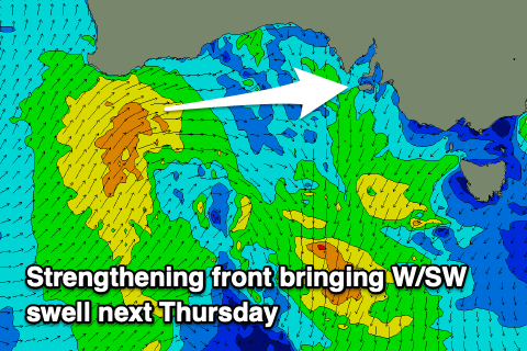
Wednesday will become smaller and the cold front will bring a strong W/SW change shortly after dawn. With this the Mid Coast should kick to 2ft during the afternoon, with no major change in size for the South Coast.
A moderate sized, mid-period W/SW swell should fill in through Thursday, generated by the low as it pushes under Western Australia Tuesday with sets to 2-3ft expected on the Mid Coast and 3ft surf across Middleton. Winds will favour the gulf as a high slides in behind Wednesday’s change, bringing S/SE breezes Thursday, more E/SE on Friday morning as the swell eases.
We’ll have a closer look at this Monday though. Have a great weekend and Merry Christamas!