Plenty of surf days to work with from the weekend

South Australian Surf Forecast by Craig Brokensha (issued Wednesday December 21st)
Best Days: South Coast Saturday morning, Sunday morning and Monday morning, both coasts Monday afternoon and Tuesday morning, South Coast Wednesday morning
Features of the Forecast (tl;dr)
- Moderate sized SW groundswell for Fri (peaking PM) with mod-fresh S/SW winds
- Easing swell Sat with variable S/SW winds, freshening through the day, smaller Sun AM with N/NE tending SE winds
- Fun mid-period S/SW swell building Sun PM with those sea breezes, easing Mon with N/NE tending SE winds (SW on the Mid)
- Large W/SW groundswell building rapidly Mon afternoon, peaking overnight, easing Tue
- Gusty N/NE tending variable SE Tue, similar Wed
Recap
Flat conditions across the Mid Coast while the South Coast saw small 1-2ft leftovers yesterday, back to 1-1.5ft across Middleton today but nice and clean. The magnets have a couple of small sliders.
This week and next (Dec 22 - 30)
Tomorrow will be a lay day as the surf eases further from today, and a trough currently moving across us brings SW winds (S/SE early Mid Coast).
Our new pulse of SW groundswell for Friday is on track, generated by a a strong though distant frontal progression that developed around the Heard Island region over the weekend. Unfortunately winds will linger from the S/SW down South, moderate to fresh in strength creating average conditions. The swell should build to 3ft to occasionally 4ft into the afternoon across Middleton with tiny surf on the Mid Coast.
Lighter S/SW breezes are due on Saturday morning, though conditions will still be lumpy/slightly crumbly and we’ll see easing sets from 3ft across Middleton. While not ideal there should still be some fun options for a surf.
Sunday looks much better with a N/NE offshore and fun new mid-period S/SW swell on the build.
This swell will be generated by a tight but good low, with a fetch of strong to gale-force W/SW winds projecting through our swell window over the coming days.
The swell should arrive late morning Sunday and build to 3ft+ across Middleton and 1ft on the Mid Coast. Unfortunately sea breezes will be in by the time the swell peaks, with Monday morning looking fun as the swell eases under a N/NE offshore again.
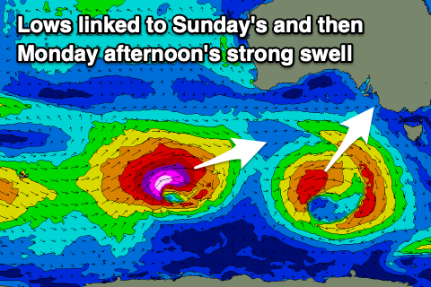
Now, moving into the afternoon, a large long-period W/SW-SW groundswell is expected to arrive, building towards a peak overnight, then easing Tuesday.
The source of this swell will be a significant, ‘bombing’ low forming to the south-west of Western Australia. A ‘bombing’ low is one which drops at least 24hPa within a 24 hour period and this will do so during Friday.
As a result, we’ll see a significant fetch of storm-force W/SW winds projected east towards us, weakening once pushing under the country through Sunday and then dipping away to the south-east.
With the eastward projection and likely captured fetch scenario, we’re looking at a rapid, large increase in size Monday afternoon, building to 6ft+ across Middleton with 8ft sets on the deep water reefs and 2-3ft on the Mid Coast.
Winds will shift sea breezy into the afternoon, creating bumpy conditions before swinging back offshore into the evening on the Mid Coast.
The swell will ease Tuesday from the 4-5ft range down South and 2ft on the Mid Coast as winds freshen from the N/NE during the morning. More variable sea breezes may be seen into the afternoon but we’ll review this Friday.
Wednesday looks to be clean again for the South Coast as the swell eases further, with a trough bringing an onshore change Thursday. We may see some small mid-period W/SW swell for later in the week but we’ll look at this in more detail Friday.
Comments
just curious, do you think ments is goin to be blessed by cyclone darian at all craig? maybe rare west swell even?
Not much at all. It's too far west and there's no major fetch aimed towards the islands. The swell will be aimed mostly towards Madagascar.
What!! swell and offshore winds at the same time in Adelaide? Surely not
Nice Xmas present