Good swell late week but onshore

South Australian Surf Forecast by Craig Brokensha (issued Monday December 19th)
Best Days: This morning South Coast magnets, beginners at Middleton tomorrow and Wednesday mornings, South Coast Saturday and Sunday morning
Features of the Forecast (tl;dr)
- Small to tiny mix of SW and SE swell for the coming days
- NE-N tending E/NE winds tomorrow, similar Wed ahead of a late SW change
- Moderate sized SW groundswell for Fri with mod-fresh S/SW winds
- Easing swell Sat with variable tending S winds, smaller Sun with N/NE tending SE winds
- Possible good new groundswell Mon week with morning NE winds
Recap
Fairly average waves all weekend down South with easterly winds and junky surf, improving mid-late morning yesterday and best just before sea breezes kicked in. Today we've got cleaner conditions and peaky 2ft sets across Middleton, best on the swell magnets for the keen.

Small peaky options this AM
This week and weekend (Dec 20 - 25)
The coming period looks fairly average surf wise, with small to tiny surf due to dominate the coming days with favourable morning winds for the South Coast, swinging onshore with a trough late week as a good new SW groundswell fills in.
It looks like the South Coast will come in at 1-2ft tomorrow and Wednesday morning before bottoming out into the afternoon and Thursday.
Morning NE-N winds are due tomorrow, shifting E/NE into the afternoon, while Wednesday should play out similar before a trough brings a late SW change. The trough will be weak, with lingering W/SW-SW winds due into Thursday morning, strengthening into the afternoon as a stronger change starts to develop.
Unfortunately the timing of this change and lingering, moderate-fresh S/SW winds on Friday will spoil a new SW groundswell that's due to fill in and peak through the day.
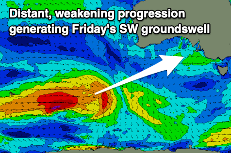
This swell is being generated by a polar frontal progression that's currently just east of the Heard Island region, with a fetch of W/SW gales being projected east. We'll see the storm weakening into this evening, with the swell due to arrive overnight Thursday and build through Friday ahead of a peak into the afternoon.
It'll be inconsistent but sets to 3ft to occasionally 4ft are due across Middleton Friday (peaking from mid-late morning), while the Mid Coast looks to come in at 1ft.
The swell should ease slowly from 3ft on the sets Saturday morning across the South Coast and winds look to become variable, possibly SW as a weak trough clips us again. We'll review this again on Wednesday but Saturday morning looks to be worth penciling in for a surf.
Sunday morning should offer a more reliable N/NE offshore ahead of sea breezes and with easing sets from the 2ft+ range.
Longer term a couple of stronger lows look to form to the south-west of Western Australia late this week and through the weekend, bringing some possible larger surf into early next week, but we'll have a closer look at this Wednesday. Winds could also be favourable and from the north-east, but check back here next update.