Classic winter pattern on the boil for next week

South Australian Surf Forecast by Ben Matson (issued Wednesday 26th October)
Features of the Forecast (tl;dr)
- Poor surf Thurs/Fri
- OK surf Sat/Sun at Victor
- Large stormy for Mon/Tues, waves on the metro beaches
- Large mix of windy swells from Wed thru' Sat
Recap
Onshore winds have maintained average surf conditions at Victor, with tiny conditions on the Mid.
This week (Oct 27 - 28)
Still nothing of interest for the rest of the week.
Thursday will be between swells, along with freshening westerly winds as a low pressure system develops just to our south. All coasts will be tiny, but we'll see building windswells down south into the afternoon. The fetch length is too short (and positioned generally out of the swell window) to provide any decent surf for the Mid, given the accompanying onshores.
On Friday, we'll see a gradual easing of winds - though it'll still be onshore on the mid and cross-onshore at Victor. Surf size will remain small on the Mid with the arrival of a minor groundswell (inconsistent 1-2ft sets tops) and Victor will see more size, perhaps 2-3ft at Middleton, but it's really not going to be worth your time and effort.
So, fuggedaboutit.
This weekend (Oct 29 - 30)
We'll see OK waves on the weekend, mainly at Victor.
Friday's system will clear to the east, allowing winds to abate locally and tend light and variable, so the surf should improve at Victor with a mix of swells from the SW and S offering 2-3ft sets at Middleton.
Sunday looks better with easing swells but freshening northerly winds and a pre-frontal trough approaches from the west. There is a risk that conditions may become a little blustery, but size will be idea for the open stretches (Goolwa, Waits, Parsons) in the morning. A gusty westerly change is pegged for mid-late afternoon.
On the Mid, small leftover groundswells may provide 1-1.5ft sets on Saturday, with smaller, wind affected waves for Sunday. The afternoon westerly change won't have enough depth to provide a late increase in surfable windswell.
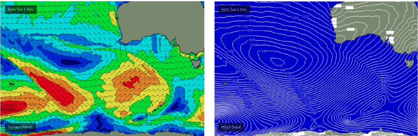
Next week (Oct 31 onwards)
Yep, we've got a whole stack of surf due next week, as a Long Wave Trough amplifies across the entire southern expanse of the continent.
Early indications are for a series of powerful fronts to cross the coast on Monday and Tuesday, delivering large stormy surf inside the gulf, probably 4-5ft on the Mid and even up to 3ft across the metro beaches.
The storm track will be quite north in the Bight will initially restrict wave heights down south, though surface conditions will be terrible anyway.
As the pattern migrates slowly east, we'll see strong S/SW fetches generate very large (but very wind affected) surf for Victor through the middle to latter part of the week.
Additionally, the Southern Ocean storm track charge nicely through out primary swell window (see below) with a series of back-to-back polar lows and fronts. This is a classic winter pattern that'll result in pendulating winds from the south-western quadrant, and solid surf that should push well north of 6ft+ across the Victor stretch for a day or two, and stacks of ~3ft days along the Mid, even a few more small stormy days for metro beaches are possible.
So, waves as far as the eyes can see, for the longer term. Let's see how Friday's model runs are looking?