West swells and north-west winds

South Australian Surf Forecast by Craig Brokensha (issued Monday August 1st)
Best Days: Keen surfers both coasts tomorrow morning (though windy), South Coast Friday for the keen, South Coast Saturday morning
Features of the Forecast (tl;dr)
- Easing mix of swells tomorrow with strengthening N/NE tending N winds
- Building N/NW windswell through Wed and Thu on the Mid Coast with strong N/NW winds (weakest Wed)
- Building W swell Wed PM, further Thu but peaking Fri with gusty W/NW winds
- Easing W swell on the weekend with fresh W/NW tending W/SW winds Sat, lighter Sun but tiny
- New S swell for the South Coast Sat, easing Sun with W/NW tending SW winds
Recap
Saturday saw a drop in swell from Friday but with great conditions down South, best on the swell magnets. Yesterday was clean again but tiny as the swell bottomed out.
The Mid Coast was great on Friday but the swell all but gone on Saturday, choppy and wind affected yesterday.
Today a small mix of new, inconsistent SW groundswell and weak W'ly swell are providing clean 2ft waves down South and a choppy 2ft on the Mid Coast.
This week and weekend (Aug 2 - 7)
We've got plenty of westerly swell due over the coming period owing to a broad, multi-centred low moving in from Western Australia.
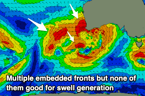 This slow moving system will produce multiple fetches of strong to gale-force westerly winds in our western swell window which is favourable for the Mid Coast but not so for the South Coast. Kangaroo Island will block most of the energy unfortunately.
Coming back to tomorrow and our mix of inconsistent groundswell and localised windswell from a front moving across us should both ease during the day, backing off from 1-2ft on the Mid Coast and 2ft on the sets across Middleton and Goolwa.
The Mid will be bumpy but workable for the keen under a strengthening N/NE breeze, tending more N through the day but likely holding from the N/NE into the evening. This will create clean but blowy conditions down South so put in those extra strokes.
A low point in swell is due on Wednesday as winds persist out of the N/NW, strong at times, holding Thursday while increasing in strength more noticeably.
This strengthening and weakening will be associated with each embedded front pushing in from the west, then dipping south-east away from us. The pattern will kick up some localised N/NW windswell on the Mid Coast from Wednesday but swell wise, the first pulse of W'ly energy is due Wednesday afternoon to 1-2ft ahead of a better pulse on Thursday to 2ft. Conditions will be a choppy mess with the strong N/NW winds though. The South Coast isn't due to any size from these initial pulses with the swell being way too west.
At this stage the most size looks to fill in Friday with 2-3ft sets due across the Mid Coast with possible small 2ft sets across Middleton to Goolwa and with strong W/NW winds, abating through the day.
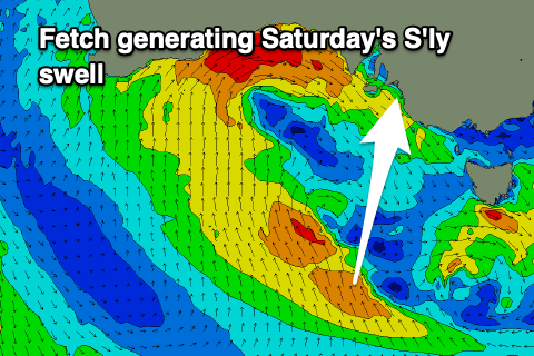 A fresh W/NW breeze will give into a late morning W/SW change on Saturday and the W'ly swell energy will fade across both coasts. The South Coast should see some fun new S'ly swell, generated by one of the embedded fetches generating a fetch of strong to gale-force S/SE winds through our southern swell window Thursday.
This should produce a fun 3ft wave across most locations (a bit bigger on the magnets) and with that morning W/NW breeze. The Mid looks to ease from 2ft.
Lighter winds should develop in the wake of Saturday's change come Sunday with easing surf from 1ft on the Mid Coast, 2ft+ down South.
Looking longer term and there's still nothing major on the cards for next week but check back here over the coming week for further updates.