Fun weekend with tricky winds next week but plenty of swell

South Australian Surf Forecast by Craig Brokensha (issued Friday April 8th)
Best Days: Mid Coast tomorrow, South Coast tomorrow and Sunday ahead of the change, Thursday morning South Coast
Features of the Forecast (tl;dr)
- Inconsistent, mid-period W/SW swell for Sat with N/NE-NE tending variable winds (NE tending variable NW on the Mid), smaller Sun with mod N/NW winds ahead of a mid-afternoon SW change
- Tiny W/SW swell Mon/Tue with freshening S/SE winds
- Small S groundswell Mon PM
- Easing surf Tue with E tending fresh SE winds
- Mod-large S/SW groundswell for Wed PM with strong E/SE winds, easing Thu with NE tending S/SE winds
Recap
Small, poor surf across the South Coast yesterday, 1ft+ across the Mid Coast in the morning, cleaner today down South with 2ft sets across Middleton and 0.5-1ft waves on the Mid Coast.
This week and weekend (Apr 9 - 15)
 The weekend is looking much better for surf across the South Coast with favourable winds and some fun, new swell.
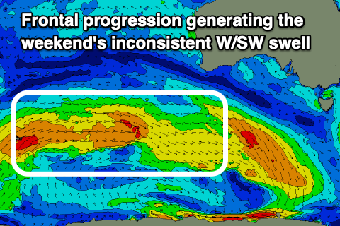
Our inconsistent, mid-period W/SW energy should be in the water tomorrow, easing slightly Sunday mixed in with some small SW groundswell.
The W/SW energy was generated by a healthy but not overly strong frontal progression through our distant swell window, south-west of Western Australia this week while the SW swell for Sunday was produced by a tight low dipping south-east through our swell window yesterday.
Middleton should see inconsistent 2-3ft sets tomorrow (biggest towards Cliffs and Goolwa), smaller and to 2ft on Sunday while the Mid Coast should see 1-1.5ft sets for the most part with possible 2ft sets on the magnets, easing from 1-1.5ft Sunday.
 Winds will be good tomorrow with a N/NE-NE breeze, tending variable into the afternoon, with the Mid Coast seeing NE tending variable NW winds. An approaching trough will see moderate N/NW winds ahead of a mid-afternoon SW change on Sunday (early N/NE on the Mid Coast).
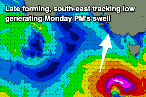
Monday looks poor with freshening S/SE winds due in the wake of Sunday's trough, but we may see lighter E/SE winds at dawn for the keen. A fresh pulse of short-lived S/SW groundswell is due to fill in, generated by a late forming low at the base of the trough moving through Sunday and this will see a spike to 3ft through the afternoon across Middleton, easing rapidly from 2ft on Tuesday.
With those winds conditions will be average though. Tuesday may see dawn E'ly winds though quickly reverting back to the SE which is less than ideal. It's worth noting there'll also be a tiny W/SW swell to 1ft on the Mid Monday for beginners.
 As we move into Wednesday a deepening inland trough and low will bring strengthening E/SE winds and poor conditions to the South Coast, with a window of lighter NE winds Thursday before reverting back to the S/SE into the afternoon and Friday.
This will spoil a strong new S/SW groundswell that's due Wednesday, produced by a significant polar low that will develop south of Western Australia Sunday evening, with a great fetch of severe-gale to storm-force W/SW winds due to be generated through our southern swell window.
The swell should build through Wednesday and peak into the afternoon to 5-6ft across Middleton but with those poor E/SE winds. The Mid Coast looks to be tiny thanks to the southerly nature of the swell.
Thursday looks the pick with the morning NE breeze and easing 4ft sets. Longer term there's plenty more swell inbound though winds might remain an issue. More on this Monday. Have a great weekend!