Average week for the South Coast, improving on the weekend

South Australian Surf Forecast by Craig Brokensha (issued Monday March 21st)
Best Days: South Coast for the keen tomorrow morning, Mid Coast for learners tomorrow and Wednesday, South Coast Saturday, Sunday and Monday mornings
Features of the Forecast (tl;dr)
- Small background SW swell tomorrow with light morning winds ahead of sea breezes, fresher S/SE later
- Building mix of swells Wed, peaking Thu from the S/SW with mod-fresh S/SE winds on Wed, light-mod SE on Thu, increasing later
- Easing S/SW swell Fri with moderate SE tending fresh S/SE winds
- Building mix of mid-period S/SW swell and S/SW groundswell Sat with moderate E/NE tending SE winds, easing Sun with NE tending S/SE winds
Recap
Friday afternoon's strong pulse of W/SW swell peaked into the evening, easing back into Saturday and not helped by the big early high tide which receded through the morning. This left slower 1-2ft waves on the Mid Coast, better into the afternoon with the incoming and 2ft+ sets. Yesterday was back to the 1ft to occasionally 1.5ft range.
The South Coast was peaky and cleaner with 2-3ft waves across Middleton Saturday, a little lumpy yesterday morning with variable winds and smaller, less consistent sets.
Today the Mid is still seeing 1-1.5ft sets with light winds, lumpy down South again with fun waves on the swell magnets.

Friday arvo knock-off
This week and weekend (Mar 22 - 27)
Tomorrow morning looks similar to today across both coasts with a small, reinforcing mid-period SW swell due to keep the Mid Coast ticking at 1ft to occasionally 1.5ft while Middleton should see a little kick through the day to 2ft to occasionally 3ft.
Winds will be light and out of the E/NE through the morning down South creating peaky/lumpy conditions, with sea breezes developing ahead of a freshening S/SE breeze as a trough moves in from the west.
For the rest of the week winds look poor for the South Coast as a high moves in and sits in the Bight as frontal systems push up into its south-eastern flank. This will generate pulses of mid-period S/SW swell mainly for later Wednesday afternoon and more so Thursday, with some better groundswell due on the weekend (discussed in more detail below).
A moderate to fresh S/SE breeze is due Wednesday, favouring the Mid Coast with some background swell to 1-1.5ft, with Middleton coming in around 3ft on the sets Thursday but with light to moderate SE winds.
These winds look to persist Friday as the swell eases across the South Coast, with more options due to open up into the weekend.
We're due to see the high moving in slowly under us on the weekend, swinging winds E/NE Saturday morning, lighter NE on Sunday morning along with a fun mix of new mid-period S/SW swell and S/SW groundswell.
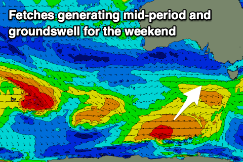 The source of these swells will be a healthy fetch of strong to gale-force winds behind the weak front projecting towards us over the coming days. The stronger gale-force fetch will be at a more polar latitude, generating the S/SW groundswell component.
The mid-period energy should be in the water at dawn with the groundswell arriving mid-late morning.
Middleton should build to 3ft to occasionally 4ft Saturday, easing Sunday but again the Mid Coast will miss out on the size due to the southerly direction. Longer term we've got further pulses of what looks to be moderate sized S/SW swell into early to mid-next week but with unfavourable winds from Tuesday. More on this Wednesday but.