Slowly improving winds with plenty of swell

South Australian Surf Forecast by Craig Brokensha (issued Wednesday March 9th)
Best Days: Keen surfers tomorrow morning, Friday through Wednesday mornings though best Sunday/Tuesday/Wednesday
Features of the Forecast (tl;dr)
- Easing SW swell tomorrow with moderate E'ly winds, shifting S/SE and strengthening
- Reinforcing mid-period SW swell Fri with light-moderate E/NE winds and S/SE sea breezes, easing Sat with similar winds
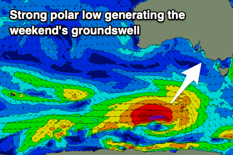
- New S/SW groundswell Sun AM with NE tending S/SE winds, easing Mon with E/NE tending S/SE winds
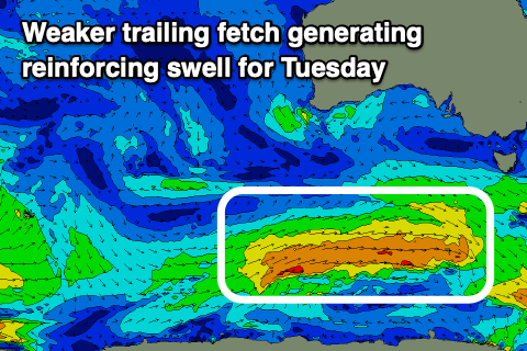
- Reinforcing mid-period S/SW swell Tue with N/NE tending S/SE winds, easing Wed with similar winds
Recap
Terrible conditions across the South Coast yesterday and today with strong onshore winds and a sizey S/SE windswell yesterday, and some stronger SW swell today. The Mid Coast has been tiny and wind affected yesterday, a bit cleaner today but near flat with the swell being a bit too south in nature.
This week and next (Mar 10 - 18)
Over the coming days we'll see winds slowly improve for the South Coast as a strong low that's been impacting the East Coast shifts off to the east, allowing winds to shift more E'ly.
Today's mix of swells will ease into tomorrow but not below 3ft across Middleton and conditions will be slightly better but still wobbly and all over the place. A moderate E'ly wind is expected, shifting E/NE at period before strengthening from the S/SE into the afternoon.
 Friday should see lighter E/NE winds across the coast along with a reinforcing mid-period SW swell generated by a healthy fetch of strong W/NW winds trailing the low linked to today's swell. This should keep Middleton around 3ft, while the Mid Coast looks to be tiny over the coming days and the swell, too small, weak and south in nature.
Saturday morning looks to play out similar to Friday with a light morning E/NE breeze but easing swell from the 2-3ft range across Middleton. With these winds spots like Goolwa and more easterly aligned breaks will perform best.
Our new pulse of S/SW groundswell for Sunday is on track, with a strong but tight polar low due to form south-west of Tasmania tomorrow, generating a fetch of gale to severe-gale W/SW winds. A good kick in size to a strong 4ft on the sets is due across Middleton, but expect mostly 3-4ft sets and a light NE offshore wind will create good conditions ahead of afternoon sea breezes. The Mid Coast will remain tiny with the swell being too south in nature.
 Winds look to swing back to the E/NE on Monday morning with a drop in S/SW swell, cleaner again Monday and Tuesday mornings with better N/NE winds.
A reinforcing pulse of mid-period S/SW swell should keep 3ft sets hitting Middleton on Tuesday but we'll have a closer look at this next update.
Longer term there's finally some possible stronger Southern Ocean frontal activity firing up south-west of Western Australia mid-late next week, generating swell for us the weekend of the 19/20th. More on this in the coming updates.
Comments
It looks like the season is starting to turn
Its been a long time coming eh cgrover!
Not many options over the last month or two. Bad luck if you can only surf on the weekend!
Yeah weekend's have been generally poor. Such a bummer when it lines up like that and gets stuck in the pattern.
I'm feeling that the La Nina pattern has still got a bit to run