Fun South Coast over the coming days before onshore winds kick in

South Australian Surf Forecast by Craig Brokensha (issued Wednesday March 2nd)
Best Days: South Coast tomorrow and Friday mornings, Mid Coast late Saturday, beginners on the Mid Coast Sunday morning, South Coast late next week
Features of the Forecast (tl;dr)
- Inconsistent SW groundswell tomorrow with light N/NE tending SE winds
- Easing SW swell Fri with light W/NW winds, shifting W/SW, strengthening later from the W/NW
- Small, mid-period W/SW swell Sat with strong S/SW winds, easing Sun with strong S/SE winds
- Mix of new SW groundswell and S/SE windswell Sun with strong S/SE winds, easing Mon with fresh S/SE winds, strengthening into the PM
- Moderate sized SW groundswell for Wed with strong S/SE winds, easing a touch Thu with morning E/NE winds, smaller Fri with a NE offshore
Recap
Light winds and clean, fun, peaky waves on the South Coast the last two mornings, biggest yesterday and a bit slower today with a wait for the 3ft sets across Middleton. The Mid Coast has been tiny to flat.
This week and next (Mar 3 - 11)
Looking at the forecast from the weekend into next week, tomorrow and Friday mornings will be worth making the most of with light offshore winds down South and some small, fun swell.
A new, inconsistent SW groundswell is due tomorrow, generated by a strong but distant low at the end of the progression linked to yesterday's and today's waves. It should keep infrequent 2ft to occasionally 3ft sets on the Surf Coast with the Mid Coast remaining tiny to flat.
Winds will be light from the N/NE ahead of E/SE sea breezes so get in through the morning across exposed breaks. On Friday the swell will start easing from an inconsistent 2ft across Middleton with a weak trough moving through bringing weak W/SW winds, but a local W/NW breeze is likely through the morning, strengthening into the late afternoon and evening as a mid-latitude low approaches from the west.
Some localised windswell is likely later in the afternoon and evening on the Mid Coast but only to 1-1.5ft.
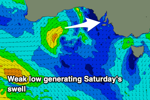 On Saturday some better mid-period W/SW swell is due across the Mid Coast, with it being generated by the mid-latitude low from this afternoon as it develops south of the Western Australian coast.
A slow moving fetch of strong W/SW-SW winds will be aimed through our swell window, a bit weaker than forecast on Monday.
This might impact the size a touch with surf generally to a weak 1.5ft with the possiblity of the odd 2ft'er in the mix on the favourable parts of the tide Saturday, fading from 1ft to maybe 1.5ft Sunday.
The South Coast won't see any size from this system, but some poor quality S/SE windswell will develop later in the day Saturday and peak as the low continues east and strengthens off the far southern NSW coast.
Winds on Saturday now look poor and strong from the S/SW, improving possibly on dark with Sunday seeing strong S/SE winds but with the tiny, fading swell.
Also in the mix down South on Sunday will be a good SW groundswell, generated by a strong, slow moving low that's currently east of the Heard Island. This is a moot point with the poor conditions and localised windswell though with sets to 3ft due to be hidden under the strong S/SE winds.
 Monday won't fair any better with gusty S/SE winds due to persist, strengthening into the afternoon and persisting Tuesday as a strong high edges in slowly from the west.
As we move into Wednesday and Thursday conditions are due to improve across the South Coast with the high sliding further east, tipping winds around to the E/NE on the former and NE on the latter.
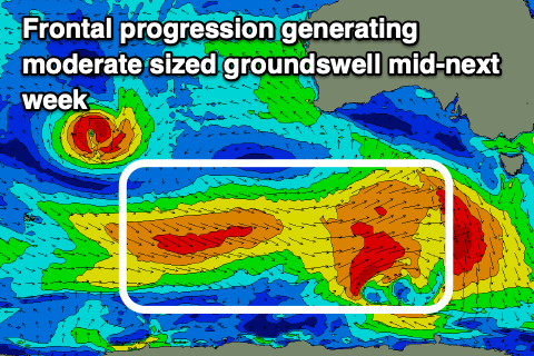
Swell wise a good pulse of SW groundswell is due Wednesday and Thursday, generated by a healthy frontal progression moving under the country on the weekend. Size wise 4ft surf is due across Middleton on Wednesday, easing a touch through Thursday with Friday seeing easing 3ft sets down South.
The Mid Coast will remain tiny and to 0.5-1ft and only for beginners on the beaches. We'll go over this and confirm the swell and local winds on Friday.
Comments
Friday now looking onshore sw in the morning.
Depends on timing of the change, looks like and local effects should steer it W/NW hopefully.