The period becomes harder to find a quality wave

South Australian Surf Forecast by Craig Brokensha (issued Monday February 21st)
Best Days: South Coast tomorrow morning and for the keen Wednesday, South Coast Saturday, Sunday and Monday mornings
Features of the Forecast (tl;dr)
- Moderate sized mid-period S/SW swell tomorrow, easing Wed
- Light E/NE tending S/SE winds tomorrow, light E/SE-SE tending S/SW Wed
- Strong S/SE winds on Thu and Fri with building levels of S/SE windswell
- Tiny W/SW swell Thu
- Variable winds Sat, Sun and Mon mornings
- Small-mod SW swell Wed-Fri next week with light morning winds
Recap
Friday afternoon's large kick in swell eased back a touch into Saturday but the sets were still solid and conditions workable and lumpy with 4-5ft sets off Middleton. The Mid Coast was fun on the right equipment and to 1-1.5ft with the swell easing back to 1ft yesterday. The South Coast was great yesterday morning with a mix of reinforcing swells and a light W/NW offshore and 3-4ft sets across Middleton.
Today a trough has brought onshore winds with reinforcing levels of mid-period S/SW swell maintaining 3-4ft surf down South, tiny and bumpy on the Mid Coast.
This week and weekend (Feb 22 - 27)
Today's onshore change is linked to a healthy polar front clipping the state and this will bring a reinforcing pulse of mid-period S/SW swell tomorrow down South thanks to a fetch of strong to near gale-force S/SW winds.
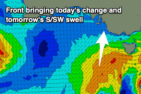 Middleton should hang around 3ft+ before starting to ease from 2-3ft on Wednesday morning while the Mid Coast will be tiny owing to the southerly swell direction and shadowing effects of Kangaroo Island into the gulf.
Winds will start to improve into tomorrow again, shifting E/NE through the morning ahead of S/SE sea breezes while Wednesday looks a touch dicey with light E/SE winds, shifting S/SW through the day as a trough approaches from the west.
Therefore make the most of tomorrow's peaky/lumpy offerings.
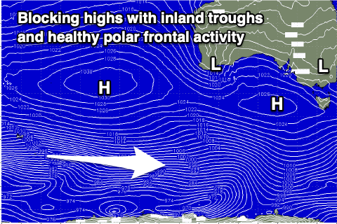
Unfortunately Wednesday's trough will be followed by a strong, slow moving high pressure system which will be squeeze by deepening inland surface troughs across both Eastern and Western Australia.
This will bring strong S/SE winds Thursday and Friday, possible tending variable Saturday, Sunday and Monday mornings as the troughiness moves across us.
 Swell wise, a weak front moving through this evening and tomorrow from the west doesn't look to generate any major size with a weak 2ft wave persisting across Middleton Thursday, 0.5-1ft on the Mid Coast.
Another weak front may generate some weak mid-period swell for Friday afternoon and Saturday but localised levels of windswell will be more visible to 2-3ft.
Sunday looks smaller with a mix of swells easing from 2ft or so.
Longer term, the blocking high will keep swell activity a little subdued through next week, but there is still some healthy polar frontal activity forecast. This should provide fun surf to 2-3ft or so across Middleton next Wednesday through Friday with what looks to be favourable morning winds. More on this Wednesday though.
Comments
I didn't think it was possible, but this summer's been even worse than the last one! The only way I still feel like a surfer is by the fact that I still watch other people surfing across a small screen. I'm genuinely worried that the next time I get in the water I will have completely forgotten how it's done.
Coupla around today if you were flexible.. in more ways than one!