Lots of swell but tricky winds

South Australian Surf Forecast by Craig Brokensha (issued Wednesday February 16th)
Best Days: Mid Coast Saturday, Mid Coast early Sunday for beginners, early Sunday keen surfers South Coast, South Coast Wednesday morning
Features of the Forecast (tl;dr)
- Inconsistent SW groundswell building Fri with a larger pulse of mid-period swell later in the day. Fresh SW tending stronger S/SW winds
- Easing mix of SW swells Sat with moderate SE winds (E/SE down South), fresher into the PM
- Smaller mix of moderate sized groundswells Sun with variable W/SW tending fresher SW winds (likely W/NW early around Victor)
- Moderate sized SW swell Mon with fresh to strong S/SE, easing Tue with mod-fresh E/SE tending SE winds
- Easing surf Wed with E/NE tending SE winds
Recap
Clean, fun waves in the 1.5ft range on the Mid Coast all day yesterday, with a bit more size down South but average conditions only for the keen.
Today the swell has eased off a little with sets back to 3ft across Middleton while the Mid Coast is a slower 1ft to occasionally 1.5ft.
This week and weekend (Jan 17 - 20)
The mix of W/SW and SW swell seen the last couple of days will ease into tomorrow morning ahead our new mix of building SW swells into Friday.
Winds look dicey tomorrow and light to moderate out of the S/SW across all locations, a lay day for most.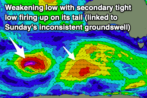
Winds will unfortunately strengthen from the SW tending S/SW into Friday as we see an initial SW groundswell building through the morning ahead of a larger short-lived pulse of mid-period SW swell later in the day.
The initial swell was generated by a strong, slow moving low that fired up east of Heard Island Sunday evening, now weakening south of the country. The swell from this source should arrive overnight tomorrow and build Friday, coming in at 3ft to occasionally 4ft in the morning, reaching 4-5ft into the afternoon though inconsistent. The Mid Coast looks to build to 1-2ft through the afternoon.
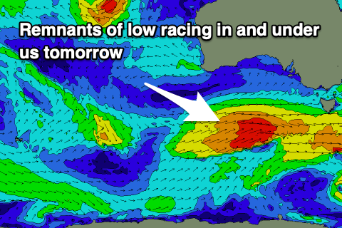
The mid-period energy will be generated by a very intense, tight low firing up on the tail of the intial weakening low, generating a fetch of severe-gale W/NW winds before racing in and under the country tomorrow, generating W’ly gales briefly through our swell window before passing across Tasmania.
 This will kick the South Coast to a stronger 4-6ft later in the day, easing from a similar size early Saturday as the Mid Coast holds that 1-2ft range.
Winds will shift SE into Saturday morning, favouring the Mid Coast with E/SE breezes developing down South, though with the large swell options will be limited.
Sunday looks a bit better for the South Coast as winds shift back to a light SW’ky (likely W/NW for a period around Victor) with the initial severe-gale fetch from the tight low today generating some inconsistent reinforcing SW groundswell to 3-4ft across Middleton.
The Mid Coast won’t see much of this energy with a drop back to 1-1.5ft expected. Make the most of the early light winds as another front clipping us will bring fresherning SW winds through the day, stronger from the S/SE on Monday as a high slides in from the west.
Some reinforcing pulses of moderate sized SW swell are due through early to mid-next week but the persistent frontal activity being aimed just east of us will unfortunately bring less than favourable winds that should improve slowly Tuesday (E/SE) and Wednesday (lighter E/NE). More on this Friday though.
Comments
Looks like the south coast will enjoy some decent swell this weekend, looking forward to it,Owe Danny Boy