Peaky weekend of surf, increasing swell next week

South Australian Surf Forecast by Craig Brokensha (issued Friday February 11th)
Best Days: South Coast tomorrow morning, South Coast Sunday morning, Mid Coast later Monday and Tuesday for the keen
Features of the Forecast (tl;dr)
- New, mid-period S/SW swell Sat with a smaller S/SE windswell and E/NE tending S/SE winds
- Easing mix of swells Sun with a new inconsistent SW groundswell in the mix with N/NE tending N/NW winds ahead of a SW change early PM
- Inconsistent mid-period W/SW swell building Mon PM, easing Tue with SE tending S'ly winds Mon (back to the S/SE late), fresh SE tending strong S/SE on Tue
- Stronger SW groundswell building later Mon, peaking Tue AM
- Easing SW swell Wed with mod SE tending fresh S/SE winds
Recap
Wednesday's strong pulse of W'ly groundswell eased back from a clean 2-3ft yesterday morning, becoming a weaker and wind affected 2ft into the afternoon. This morning there are still 1.5ft sets in the gulf for the keen, while the South Coast has been poor and onshore.

Chunky and clean yesterday AM
This weekend and next week (Feb 12 - 18)
Moving into the weekend we've got improving conditions for the South Coast but with a generally small mix of swells. A new, mid-period S/SW swell is due tomorrow, mixed in with some local windswell on the South Coast.
The source of the mid-period swell was a weak front pushing in behind the low linked to our W'ly groundswell and we should see Middleton holding around 2ft to occasionally 3ft with tiny 1ft+ waves on the Mid Coast.
Winds will shift E/NE tomorrow morning creating peaky conditions but Sunday looks best with a light N/NE-N/NW offshore and fun, inconsistent mix of swells to 2ft+ across Middleton, better on the magnets. Winds will shift onshore early afternoon so get in before then. The Mid Coast will drop further back to 0.5-1ft.
 Moving into next week and we've got our mid-period W/SW swell followed by SW groundswell, generated by the same system.
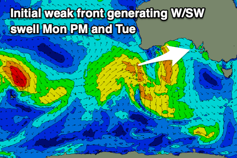
That'll be a strong mid-latitude front pushing towards and under Western Australia today, dipping south-east while forming into a strong polar low. The initial front will generate a fetch of strong W/SW winds through our western swell window, producing an inconsistent W/SW swell for later Monday and Tuesday to 1-1.5ft. There might be the odd bigger one on the favourable parts of the tide across the magnets.
The South Coast won't see any size from this source, but a brief fetch of severe-gale to storm-force W/SW winds around the polar low should generate a moderate sized SW groundswell for later Monday, peaking Tuesday morning to the 4ft range across Middleton.
 Winds will be poor for the South Coast early next week with a moderate to fresh S/SE breeze on Monday (SE tending S on the Mid) with stronger S/SE winds on Tuesday. Winds are due to ease Wednesday and be moderate from the SE in the morning, keeping conditions bumpy and average down South as the S/SW swell eases, mixed in with some local S/SE windswell.
With this wind outlook the Mid Coast will be the pick for the keen.
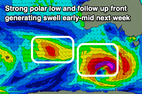
Following the polar low and front, we'll see a healthy frontal progression pushing in under the country through Tuesday to Friday, bringing strengthening S/SW winds on Thursday, back to the S/SE Friday as it clips us late week.
Moderate + levels of mid-period SW swell are due from this progression, building through Friday and holding Saturday to the 4-5ft range on the South Coast and 1-2ft on the Mid Coast. Winds may improve down South Saturday morning but we'll have a closer look at this Monday. Have a great weekend!