Poor surf continues

South Australian Surf Forecast by Craig Brokensha (issued Monday January 31st)
Best Days: Desperate surfers South Coast Saturday morning, similar Sunday morning
Features of the Forecast (tl;dr)
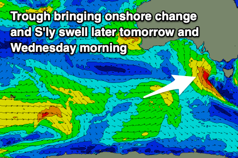
- Strengthening S/SW tending S winds tomorrow with a building S/SW swell, peaking early Wed AM with strong S/SW tending S/SE winds
- Small S/SE windswell Thu with mod-fresh S/SE winds, E/SE tending S/SE Fri
- Fading S/SE windswell Sat and Sun with E/NE winds Sat AM, NE Sun AM
- Small W/SW swell for Wed with S/SE winds
Recap
Poor surf to start off the weekend with onshore winds and a small 1-2ft of swell for the South Coast, tiny on the Mid.
A new, inconsistent SW groundswell filled in Sunday and conditions were better down South though still lumpy with a light E'ly breeze, while the Mid Coast was clean and to 1ft for beginners.
This morning conditions are lumpy and clean again down South with a variable breeze and easing surf from 2-3ft while the Mid is still clean and to 1ft, ideal for beginners.
This week and weekend (Feb 1 - 6)
 While not the cleanest, I hope everyone made the most of the yesterday's and this morning's workable conditions as from tomorrow we're looking at a poor run of winds and swell that'll slowly improve through the weekend.
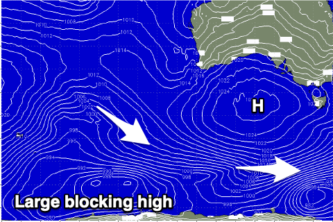
The reason for this poor run of surf and wind is a deepening trough currently moving in from the west being followed by a strong, broad high pressure system. The trough will deepen and linger in the Tasman Sea mid-late week, squeezing the north-east flank of the high, directing persistent, strong winds out of the south across us.
Coming back to tomorrow though and we'll see the trough clip us, bringing strong S/SW tending S winds along with a poor, building mid-period S'ly swell. The Mid Coast may see tiny, weak 1ft waves with building 3ft sets down South by late.
Strong S/SE winds will create poor conditions Wednesday with the S'ly swell easing from an early peaky to 3-4ft, tiny on the Mid Coast.
As the high slowly moves east we'll see winds starting to ease, still moderate to fresh from the S/SE on Thursday, swinging E/SE Friday morning and then back to the S/SE through the afternoon while strengthening.
 There isn't expected to be any quality swell in the water with local windswell making up the bulk of the size.
Cleaner conditions should develop through the weekend as the high continues east, swinging winds E/NE through the morning on Saturday and the NE on Sunday.
Swell wise, the local S/SE windswell will start to fade in size and power as the source of swell generating S/SE winds is cut off. Middleton should ease back from 2ft+ on Saturday, with 1-2ft leftovers Sunday. The Mid Coast looks to be tiny to flat through this period.
Into next week winds will continue to improve but there'll be no new swell in the water. A trough looks to bring another change on Tuesday but swell wise the blocking high will keep a lid on things. It looks like we'll see a small W/SW swell from the Mid Coast on Wednesday in the wake of the trough but we'll have another glance at this Wednesday.