Poor outlook continues

South Australian Surf Forecast by Craig Brokensha (issued Wednesday January 5th)
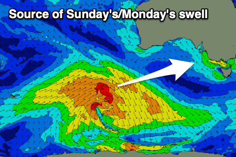
Best Days: Sunday morning on the South Coast for desperate surfers, Mid Coast later Sunday and Monday for the keen on bigger boards
Features of the Forecast (tl;dr)
- Junky S'ly and S/SW windswell from today through Fri with strong S/SW tending SW winds tomorrow, SW tending S/SW on Fri
- Inconsistent, mid-period SW swell building Sun, peaking Mon with SE tending S/SE winds (likely E/NE for a period down South Sun AM), strengthening S/SE Mon
- New S/SE windswell Tue with strong SE tending S/SE winds
Recap
OK conditions for the keen yesterday down South in the morning with a bumpy mix of swells to 2-3ft. The Mid Coast was tiny and full but an underlying 1-1.5ft of swell showed into the afternoon and on the incoming tide though with bumpy conditions.
Today the South Coast is a write-off with tiny, full 1ft sets continuing across the Mid Coast.
This week and next (Jan 6 - 14)
The pattern of strong south to south-east winds is in and we're set to see it continue through the end of the week, weekend and most of next week.
We're seeing a progression of strong, blocking highs developing to our west, then sliding in eastward while squeezing against inland surface troughs.
This brings persistent, strong winds from the southern to south-eastern quadrant while also blocking our main swell windows.
The Mid Coast will see small levels of choppy windswell developing tomorrow and holding Friday (max 1-2ft) while the South Coast will see moderate levels of S/SE windswell to 3-4ft tomorrow, easing a touch into Friday. Winds will be strong from the S/SW tending SW tomorrow with strong SW tending S/SW winds on Friday.
 Winds look to switch back to the S/SE and be fresh on Saturday with a further drop in size, while we should see a period of lighter E/NE winds on Sunday morning down South. Size wise though we'll be looking at weak levels of easing S'ly windswell from 2ft.
Some new, mid-period SW swell should be on the build though, generated by a broad polar low that's formed south-west of Western Australia. An initial off axis, strong to near gale-force NW winds will be followed by a better aligned fetch of strong to gale-force W/SW winds this evening and tomorrow.
This secondary fetch should generate the best pulse for later Sunday and Monday morning. The Mid Coast should build to 1-1.5ft late in the day and persist around this size Monday with the South Coast peaking to 3ft Monday morning. Winds will unfortunately strengthen from the S/SE again into Monday as a ridge of high pressure moves in from the west, strong from the SE tending S/SE on Tuesday with new levels of S/SE windswell.
Later in the week winds are expected to improve and swing offshore down South but there isn't expected to be any decent swell in the water owing to the blocking nature of the persistent highs. More on this Friday.
Comments
Worst summer I can remember!
Il nino is code for el crappo in the southern ocean
La Niña ;) But as a positive, less heat waves and fires..
i new i would get those 2 mixed up, same result though.
Hey Craig, does la nina Mean a crappy autumn too?