Fun weekend down South, then poor next week

South Australian Surf Forecast by Craig Brokensha (issued Friday December 10th)
Best Days: South Coast tomorrow morning and Sunday morning, Mid Coast Thursday afternoon and Friday (South Coast Friday), Mid Coast next weekend
Features of the Forecast (tl;dr)
- Late pulse of new S/SW groundswell this afternoon, easing slowly tomorrow with light-mod E/NE tending mod-fresh SE-S/SE winds
- Reinforcing mid-period S/SW swell Sun with N/NE tending SE winds
- Smaller Mon with SW winds
- Weak SW swell Tue with SE tending S winds, easing Wed with S tending S/SW winds
- Inconsistent W/SW groundswell building Thu with SE tending S/SE winds, easing Fri with NE tending variable winds
- Secondary W/SW swell for next weekend
Recap
Strong onshore winds and poor surf across the South Coast yesterday, improving a touch this morning with winds shifting more E'ly. The Mid Coast has offered tiny 0.5-1ft waves best suited to beginners on the beaches around the lower tides.
This week and weekend (Dec 9 – 12)
The coming weekend looks fun for surf across the South Coast with improving conditions and fun levels of S/SW swell energy.
Firstly coming back to today, and we should see a good pulse of new S/SW groundswell kicking this afternoon down South, generated by a good polar low moving under the country earlier this week.
Middleton should kick to 3ft+ and we'll see it dropping from a similar size tomorrow morning, further Sunday but slowed by a reinforcing pulse of mid-period S/SW energy. The source of the reinforcing swell is a polar front firing up on the tail of the polar low, with it currently passing under Tasmania today.
This should keep Middleton around 2-3ft most of Sunday before easing back to 2ft on Monday. With the southerly swell direction, Kangaroo Island will shadow the Mid Coast resulting in tiny to flat surf.
Winds tomorrow should be light to moderate out of the E/NE, creating peaky fun options at those spots that like north-east winds ahead of moderate to fresh SE tending S/SE sea breezes.
Sunday will be cleaner again with a N/NE offshore, giving into weaker SE sea breezes early afternoon.
 Monday will be a lay day as another trough moves in from the west, bringing a S/SW change. There might be a tiny 0.5-1ft of swell generated for the Mid late Monday but more so Tuesday from the trough with the South Coast seeing a kick in size to 2-3ft through Tuesday, peaking into the afternoon.
Winds will remain poor for the South Coast but and fresh from the SE, tending S/SE through the day with S'ly tending S/SW winds on Wednesday as another trough moves in from the west.
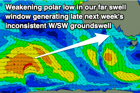
Of greater importance is the W/SW groundswell due into Thursday and Friday next week along with a reinforcing pulse of slightly more consistent energy on the weekend.
The first swell will be generated by a strong though distant polar low that's currently south-east of South Africa.
 This low will produce a great fetch of gale to severe-gale W'ly winds while pushing east across the Heard Island region over the coming days, weakening south-west of Western Australia Sunday evening. It'll be inconsistent but we should see the swell building to 1-2ft on the favourable parts of the tide Thursday afternoon on the Mid Coast, easing back from a similar size on Friday. The South Coast only looks to produce inconsistent 2-3ft sets. Winds will be out of the SE tending S/SE on Thursday and then NE Friday but we'll have to confirm this Monday.
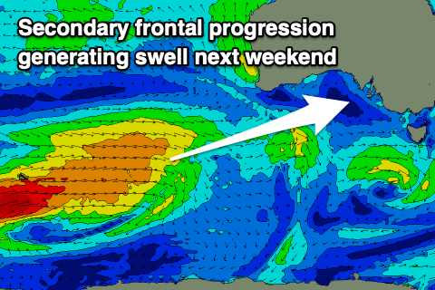
On the weekend a secondary pulse of W/SW swell is due, generated by a secondary frontal progression firing up on the tail of the weakening low, south-west of Western Australia. This should hopefully produce a little more consistency with sets to 2ft on Saturday/Sunday. We'll have a closer look at this Monday though. Have a great weekend!