Upgrade in the coming westerly swell

South Australian Surf Forecast by Craig Brokensha (issued Wednesday December 1st)
Best Days: Mid Coast Friday and Saturday morning, beginners on the Mid Coast Sunday
- Features of the Forecast (tl;dr)
- Inconsistent W/SW swell arriving later tomorrow, peaking Fri as a better, stronger W/SW groundswell fills in
- S/SE tending S/SW winds tomorrow with SE tending gusty SW winds Fri, back to the S/SE late
- Easing W/SW swell Sat with gusty S/SE winds, smaller Sun with fresh SE tending S/SE winds
- Fading surf Mon with lighter E/SE tending S/SE winds down South
Recap
A fun hot day of surf yesterday with all day offshore winds and a small swell to 2ft across Middleton, better on the more exposed breaks. Today a shallow onshore change has moved in a little earlier than expected along with a drop in size leaving poor surf down South.
The Mid Coast has offered tiny 0.5-1ft waves at times that have only been suitable for beginners.
This week and weekend (Dec 2 - 5)
With the trough moving in today we'll see winds remain poor for the South Coast into the end of the week, persisting into the weekend and unfortunately most of next week.
Luckily though we've got some fun W/SW swell on the way and there's an upgrade in one of the pulses due Friday.
Looking at tomorrow morning though and the surf will reach a low point with moderate S/SW winds down South (S/SE early on the Mid but tiny).
Later in the day we should see the first signs of new, inconsistent W/SW swell, generated by a strong polar low that fired up around the Heard Island region on the weekend. A good fetch of gale-force W/SW-W winds were projected through our swell window and a late kick to 1-1.5ft is likely on the Mid Coast tomorrow as winds shift S/SE.
Friday is a much better proposition on the Mid Coast as a stronger pulse of W/SW groundswell fills in, generated by a small, strong low that's developed south of Western Australia today. This has been upgraded in strength with a fetch of gale to severe-gale W/SW winds projected through our western swell window, on top an active sea state.
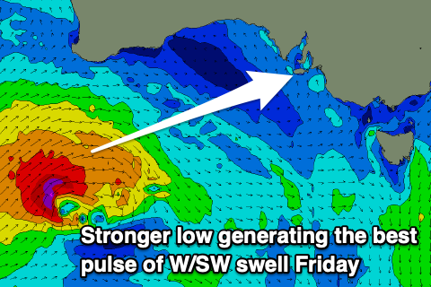 This will produce a good pulse of swell to 2ft+ on the Mid Coast with 3ft sets more than likely on the swell magnets working the favourable parts of the tide.
The South Coast should build to a good 4-5ft across Middleton into the afternoon but winds will favour the Mid Coast with a moderate SE wind ahead of gusty SW sea breezes, tending back S/SE on dark.
The swell should be a slightly smaller size Saturday morning across the South Coast (easing from 4ft+), with the Mid Coast easing from 2ft along with fresh and gusty S/SE winds, holding all day.
Expect the size to continue ease into Sunday, tiny on the Mid Coast but ideal for beginners and easing from 3ft or so across Middleton but with persistent and fresh SE tending S/SE winds. We may see winds shift E/SE for a period in the morning on the South Coast but conditions will be junky and poor from the previous days of onshore winds.
Next week onwards (Dec 6 onwards)
We might see winds go more variable temporarily on Monday morning but swell wise it'll be smaller again with a low point expected on Tuesday morning.
Another trough is forecast to move in from the west on Tuesday, bringing a return to S-S/SE winds that will persist into the end of the week. Swell wise there's some small to moderate sized, mid-period SW swell on the cards but we'll have a closer look at this Friday.