Fun waves the next two days

South Australian Surf Forecast by Craig Brokensha (issued Monday November 15th)
Best Days: Beginners Mid Coast tomorrow morning, South Coast tomorrow morning and Wednesday morning, South Coast Saturday afternoon
Features of the Forecast (tl;dr)
- Moderate sized, easing mid-period S swell tomorrow with variable tending S/SE winds
- Fading S'ly swell Wed with light-mod N/NE tending E/SE winds
- Low point in swell Thu with strong N/NW tending W winds
- S/SE winds Fri
- Building S/SW swell Sat with E/NE tending N/NW winds
- Easing S/SW swell Sun with a local S windswell and strong S winds
Recap
A poor weekend all round with onshore winds and small, choppy surf down South, tiny on Saturday across the Mid Coast and a bit bigger yesterday but still wind affected.
Today a larger, mid-period S/SW swell is breaking across the South Coast with solid sets but persistent onshore winds, remaining choppy and to 2ft on the Mid Coast.
This week and weekend (Nov 16 - 21)
The strong polar frontal progression and cold outbreak linked to our current weather and onshore winds is now clearing to the east and with this we'll see the weather and conditions improve, especially for the South Coast over the coming days.
 This will be well worth capitalising on as the period from the end of the week, and into the weekend is below par.
We'll see the swell swinging more S'ly through tomorrow while easing, with fading mid-period energy due from the backside of the frontal progression.
It won't be overly powerful but we should still see sets to 4ft across Middleton tomorrow morning, easing through the day and then down from a much smaller 2ft+ on Wednesday morning.
The Mid Coast will be tiny, easing from 1ft to possibly 1.5ft tomorrow morning, flat on Wednesday.
Locally winds look much better with a variable breeze due tomorrow morning down South with lumpy, but clean faces down South. The afternoon will become bumpy with moderate S/SE sea breezes, but it'll still be fun. The Mid should see E/SE tending W winds, ideal for beginners.
Moving into Wednesday, an approaching, though weakening mid-latitude low/trough will see winds swing N/NE on the South Coast creating great conditions for the swell magnets as the small swell eases. The afternoon will be average with E/SE sea breezes.
Thursday will be tiny as the swell reaches a low point and as the low/trough moves closer, stronger N/NW winds are due ahead of a W'ly change into the afternoon. This change will be very short-lived and have no substance behind it, resulting in no increase in surfable windswell on the Mid Coast.
As the low/trough pushes east Friday, winds will shift S/SE-SE but again with no considerable increase in local swell.
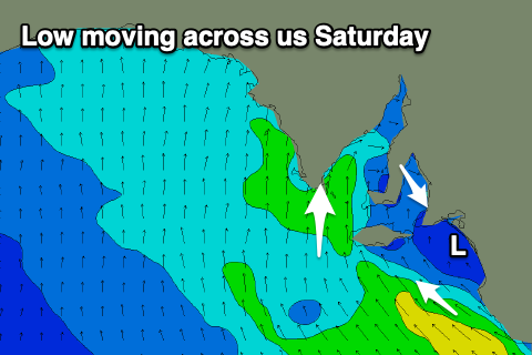 Moving into Saturday, a small, new mid-period S/SW swell is due to build through the day and winds will be funky as another low moves south-east across us. This will bring varying E/NE tending N/NW winds which will then go strong S'ly Sunday on the backside of the low.
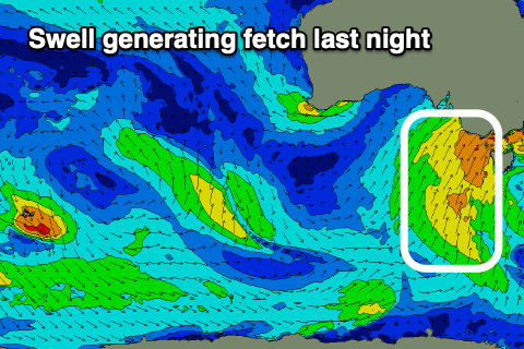
The source of the mid-period swell will be generated by a broad though weak fetch of W/SW winds projecting from the polar shelf, up towards Tasmania Wednesday through Friday. Saturday morning looks minimal and to 1-2ft but 2-3ft sets are due across Middleton into the afternoon with those favourable winds.
Sunday will then be a write off with the strong S'ly winds and junky local windswell.
Longer term the outlook remains void of any major swell activity and flukey winds but we may see more variable breezes early next week with another pulse of mid-period S/SW swell. More on this in the coming updates.